Welcome to Visit Tatsfield Places
The Walkfo guide to things to do & explore in Tatsfield
 Visit Tatsfield places using Walkfo for free guided tours of the best Tatsfield places to visit. A unique way to experience Tatsfield’s places, Walkfo allows you to explore Tatsfield as you would a museum or art gallery with audio guides.
Visiting Tatsfield Walkfo Preview
Tatsfield is located 3.3 miles north west of Westerham and 3.9 miles north east of Oxted. It is adjacent to the Surrey border with both Greater London and Kent. When you visit Tatsfield, Walkfo brings Tatsfield places to life as you travel by foot, bike, bus or car with a mobile phone & headphones.
Tatsfield Places Overview: History, Culture & Facts about Tatsfield
Visit Tatsfield – Walkfo’s stats for the places to visit
With 22 audio plaques & Tatsfield places for you to explore in the Tatsfield area, Walkfo is the world’s largest heritage & history digital plaque provider. The AI continually learns & refines facts about the best Tatsfield places to visit from travel & tourism authorities (like Wikipedia), converting history into an interactive audio experience.
Tatsfield history
Tatsfield
In 1086 it was held by Anschitill (Ansketel) de Ros from the Bishop of Bayeux. It rendered 60 shillings (£3) to its feudal overlords per year. In 1392 a grant of the manor of Tatsfield, which was alleged to have been long-concealed, was made by the Crown to John Maudelyn. In 1416–17 John de Stanyngden or Stalkynden conveyed his rights in the. manor to John Uvedale. In 1553 Sir John Gresham devised to his son William, after the death of his wife Katherine, “the farm in. Surrey and Kent where Steven of Lusted.
20th century
BBC established its Tatsfield Receiving Station in 1929. Its masts and shortwave aerials were a prominent local landmark. The station closed in 1974 when its work was merged with that of BBC Monitoring’s receiving station at Crowsley Park in South Oxfordshire.
Ancient roads
A number of ancient routes cross the parish, including the London to Lewes Way. It was constructed about 100 AD between the mentioned towns/settlements 44 miles (71 km) and 44 miles.
Tatsfield etymology
The English Place Name Society suggests it is derived from ‘a field or open land belonging to one Tatol’ The word ‘field’ denotes a clearing in The Weald, a main Anglo-Saxon forest. An alternative explanation is that the earliest community began on the hill with church, manor house and rectory.
Tatsfield geography / climate
The village itself is on the North Downs with its centre near its highest point, at an altitude of around 230 metres. The ‘village’ area is in a small salient of Surrey into the London Borough of Bromley, Greater London. The boundary with Kent is less than 1/2 mile to the east.
Why visit Tatsfield with Walkfo Travel Guide App?
 You can visit Tatsfield places with Walkfo Tatsfield to hear history at Tatsfield’s places whilst walking around using the free digital tour app. Walkfo Tatsfield has 22 places to visit in our interactive Tatsfield map, with amazing history, culture & travel facts you can explore the same way you would at a museum or art gallery with information audio headset. With Walkfo, you can travel by foot, bike or bus throughout Tatsfield, being in the moment, without digital distraction or limits to a specific walking route. Our historic audio walks, National Trust interactive audio experiences, digital tour guides for English Heritage locations are available at Tatsfield places, with a AI tour guide to help you get the best from a visit to Tatsfield & the surrounding areas.
“Curated content for millions of locations across the UK, with 22 audio facts unique to Tatsfield places in an interactive Tatsfield map you can explore.”
Walkfo: Visit Tatsfield Places Map
22 tourist, history, culture & geography spots
Tatsfield historic spots | Tatsfield tourist destinations | Tatsfield plaques | Tatsfield geographic features |
| Walkfo Tatsfield tourism map key: places to see & visit like National Trust sites, Blue Plaques, English Heritage locations & top tourist destinations in Tatsfield | |||
Best Tatsfield places to visit
Tatsfield has places to explore by foot, bike or bus. Below are a selection of the varied Tatsfield’s destinations you can visit with additional content available at the Walkfo Tatsfield’s information audio spots:
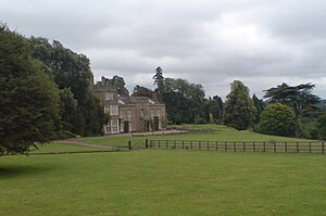
Titsey Place
Titsey Place was built by Sir John Gresham (1495–1556) on the site of a earlier dwelling. The mostly Tudor house was demolished and rebuilt in the 18th century, before being refronted in 1826. Finally a tower was added in 1856.

Tatsfield Receiving Station
The Tatsfield Receiving Station was a radio broadcasting signals-receiving and frequency-measuring facility operated by the British Broadcasting Corporation. The station was in operation between 1929 and 1974.
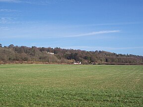
Betsom’s Hill
Betsom’s Hill is the highest point in the county of Kent at 251 metres (823 ft) Situated between Westerham and Tatsfield, at the western edge of the county. It lies close to where the A233 crosses the Downs en route to Biggin Hill.
Visit Tatsfield plaques
 2
2
plaques
here Tatsfield has 2 physical plaques in tourist plaque schemes for you to explore via Walkfo Tatsfield plaques audio map when visiting. Plaques like National Heritage’s “Blue Plaques” provide visual geo-markers to highlight points-of-interest at the places where they happened – and Walkfo’s AI has researched additional, deeper content when you visit Tatsfield using the app. Experience the history of a location when Walkfo local tourist guide app triggers audio close to each Tatsfield plaque. Explore Plaques & History has a complete list of Hartlepool’s plaques & Hartlepool history plaque map.


 Trying to encourage visitors to Tatsfield?