Welcome to Visit Belfast Places
The Walkfo guide to things to do & explore in Belfast
 Visit Belfast places using Walkfo for free guided tours of the best Belfast places to visit. A unique way to experience Belfast’s places, Walkfo allows you to explore Belfast as you would a museum or art gallery with audio guides.
Visiting Belfast Walkfo Preview
Belfast is the capital and largest city of Northern Ireland, standing on the banks of the River Lagan on the east coast . It is the 12th-largest city in the United Kingdom and the second-largest in Ireland . It suffered greatly during the violence that accompanied the partition of Ireland, and especially during the more recent conflict known as the Troubles . By the early 19th century, Belfast was a major port with commercial and industrial docks . When you visit Belfast, Walkfo brings Belfast places to life as you travel by foot, bike, bus or car with a mobile phone & headphones.
Belfast Places Overview: History, Culture & Facts about Belfast
Visit Belfast – Walkfo’s stats for the places to visit
With 203 audio plaques & Belfast places for you to explore in the Belfast area, Walkfo is the world’s largest heritage & history digital plaque provider. The AI continually learns & refines facts about the best Belfast places to visit from travel & tourism authorities (like Wikipedia), converting history into an interactive audio experience.
Belfast history
Belfast was granted city status by Queen Victoria in 1888. The city straddles County Antrim on the left bank of the Lagan and County Down on the right.
Origins
The site of Belfast has been occupied since the Bronze Age . The Giant’s Ring, a 5,000-year-old henge, is located near the city . The Normans may have built a castle on a site now bounded by Donegall Place, Castle Place, Cornmarket and Castle Lane .
The early town

Belfast was established as a town in 1613 by Sir Arthur Chichester . The mainly English and Manx settlers took Anglican communion at Corporation Church . But it was with Scottish Presbyterians that the town was to grow as an industrial port . Together with French Huguenot refugees, they introduced the production of linen .
The industrial city

Protestant workers organised to secure their access to jobs and housing, gave a new lease of life in the town to the once largely rural Orange Order . Rapid industrial growth in the nineteenth century drew in landless Catholics from outlying rural and western districts . Sectarian tensions were heightened by movements to repeal the Acts of Union and restore a Parliament in Dublin .
The Blitz and post-war redevelopment

Belfast was heavily bombed during World War II . In one raid, in 1941, German bombers killed around one thousand people and left tens of thousands homeless . At the end of the war, the Unionist Government undertook programmes of “slum clearance”
The Troubles
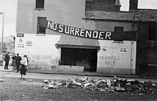
Belfast saw some of the worst of the Troubles in Northern Ireland, particularly in the 1970s . In all, over 1,600 people were killed in political violence in the city between 1969 and 2001 . The Europa Hotel suffered 36 bomb attacks becoming known as the most bombed hotel in the world .
Belfast culture & places

In the period since the Good Friday Agreement in 1998, Belfast has begun a social, economic and cultural transformation giving it a growing international cultural reputation. In 2004–05, art and cultural events in Belfast were attended by 1.8 million people (400,000 more than the previous year) The Ulster Orchestra, based in Belfast, is Northern Ireland’s only full-time symphony orchestra and is well renowned in the United Kingdom. Belfast has the highest concentration of Irish-speakers in Northern Ireland.
Media

Belfast is the home of the Belfast Telegraph, Irish News, and The News Letter . The city is the headquarters of BBC Northern Ireland, ITV and commercial radio stations Q Radio and U105 . The Paint Hall at Harland and Wolff has become one of the UK Film Council’s main studios .
Sports

The Belfast Marathon is run annually on May Day, and attracted 20,000 participants in 2011 . The Northern Ireland national football team plays its home matches at Windsor Park . Belfast is home to one of the biggest British ice hockey clubs, the Belfast Giants . Belfast produced the Formula One racing stars John Watson and Ferrari driver Eddie Irvine .
Belfast economy & business
After the Troubles
Belfast is Northern Ireland’s educational and commercial hub . Peace dividend has led to soaring property prices in the city . Employment has grown by 16.4%, compared with 9.2% for the UK as a whole .
Belfast geography / climate

Belfast is situated on Northern Ireland’s eastern coast at 54°35′49″N 05°55′45″W / 54.59694°N 5.92917°W. The city is at the western end of Belfast Lough and at the mouth of the River Lagan giving it the ideal location for the shipbuilding industry that once made it famous. The River Farset is also named after this silt deposit (from the Irish feirste meaning “sand spit”)
Climate
Belfast has a temperate oceanic climate (Cfb in the Köppen climate classification) with a narrow range of temperatures and rainfall throughout the year . The climate of Belfast is significantly milder than most other locations in the world at a similar latitude, due to the warming influence of the Gulf Stream . The highest temperature recorded at any official weather station in the Belfast area was 30.8 °C at Shaw’s Bridge on 12 July 1983 .
Areas and districts

The townlands of Belfast are its oldest surviving land divisions and most pre-date the city . The city expanded to the natural barrier of the hills that surround it, overwhelming other settlements . Belfast city centre is divided into two postcode districts, BT1 for the area lying north of the City Hall, and BT2 for its south . The rest of the Belfast post town is divided in a clockwise system from BT3 in the north-east round to BT15 .
Why visit Belfast with Walkfo Travel Guide App?
 You can visit Belfast places with Walkfo Belfast to hear history at Belfast’s places whilst walking around using the free digital tour app. Walkfo Belfast has 203 places to visit in our interactive Belfast map, with amazing history, culture & travel facts you can explore the same way you would at a museum or art gallery with information audio headset. With Walkfo, you can travel by foot, bike or bus throughout Belfast, being in the moment, without digital distraction or limits to a specific walking route. Our historic audio walks, National Trust interactive audio experiences, digital tour guides for English Heritage locations are available at Belfast places, with a AI tour guide to help you get the best from a visit to Belfast & the surrounding areas.
“Curated content for millions of locations across the UK, with 203 audio facts unique to Belfast places in an interactive Belfast map you can explore.”
Walkfo: Visit Belfast Places Map
203 tourist, history, culture & geography spots
Belfast historic spots | Belfast tourist destinations | Belfast plaques | Belfast geographic features |
| Walkfo Belfast tourism map key: places to see & visit like National Trust sites, Blue Plaques, English Heritage locations & top tourist destinations in Belfast | |||
Best Belfast places to visit
Belfast has places to explore by foot, bike or bus. Below are a selection of the varied Belfast’s destinations you can visit with additional content available at the Walkfo Belfast’s information audio spots:
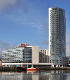 | Obel Tower The Obel Tower is located on Donegall Quay on the River Lagan beside the Lagan Weir. Measuring 85 metres (279 ft) in height, the tower is the tallest storeyed building on the island of Ireland. |
 | Custom House, Belfast The Custom House is a 19th-century B+ listed building in Belfast, Northern Ireland. Completed in 1857, the building has been used by various governmental departments, including the Belfast Board of Works, the Inland Revenue, and an Income Tax Office. HM Revenue and Customs are scheduled to relocate by 2021. |
 | Transport House, Belfast Transport House was completed in 1959 as offices for the Amalgamated Transport & General Workers Union. It is one of Northern Ireland’s youngest listed buildings. The building was listed in 1994. |
 | Golden Thread Gallery The Golden Thread Gallery was established in 1998 by Gail Prentice in a former linen mill on an ‘interface’ in North Belfast. It hosts contemporary art exhibitions and participatory events by a mix of Northern Irish and international artists. In 2002, Peter Richards, artist and curator, was appointed as the gallery’s new director. |
 | Malmaison Hotel, Belfast Malmaison Hotel Belfast is a hotel within a listed building in the city of Belfast in County Antrim, Northern Ireland. It is on the corner of Victoria Street and Marlborough Street and was formerly The McCausland Hotel. |
 | St George’s Church, Belfast St. George’s Church, Belfast is the oldest Church of Ireland church in Belfast. It was designed by Irish architect, John Bowden, and opened in 1816. Major refurbishment work was completed in June 2000. |
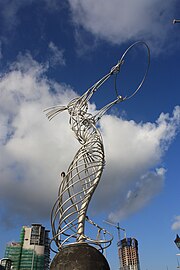 | Thanksgiving Square (Belfast) Thanksgiving Square is an area of public space in Lanyon Place in Belfast based on Thanks-Giving Square in Dallas, Texas. It contains the Beacon of Hope sculpture. |
| The Muddlers Club The Muddlers Club is a restaurant in Belfast, Northern Ireland. It was awarded a Michelin star in the 2020 Michelin Guide Great Britain & Ireland. Chef patron Gareth McCaughey founded the restaurant in 2015. |
 | Ox (restaurant) Ox is a restaurant in Belfast, Northern Ireland. It has had a Michelin star since 2016. Head chef of Ox is Stephen Toman. |
| Metropolitan Arts Centre The Metropolitan Arts Centre is a cultural hub and a vital shared space in Belfast. Opened in 2012, some 1.5 million visitors have come through the doors of the MAC. |
Visit Belfast plaques
 96
96
plaques
here Belfast has 96 physical plaques in tourist plaque schemes for you to explore via Walkfo Belfast plaques audio map when visiting. Plaques like National Heritage’s “Blue Plaques” provide visual geo-markers to highlight points-of-interest at the places where they happened – and Walkfo’s AI has researched additional, deeper content when you visit Belfast using the app. Experience the history of a location when Walkfo local tourist guide app triggers audio close to each Belfast plaque. Explore Plaques & History has a complete list of Hartlepool’s plaques & Hartlepool history plaque map.


 Trying to encourage visitors to Belfast?