Welcome to Visit Kent Places
The Walkfo guide to things to do & explore in Kent
 Visit Kent places using Walkfo for free guided tours of the best Kent places to visit. A unique way to experience Kent’s places, Walkfo allows you to explore Kent as you would a museum or art gallery with audio guides.
Visiting Kent Walkfo Preview
Kent is a county in South East England and one of the home counties . It borders Greater London to the north-west, Surrey to the west and East Sussex to the south-west . It is the fifth most populous county in England and the most populous non-Metropolitan county . The county town of Maidstone is the oldest cathedral in England . When you visit Kent, Walkfo brings Kent places to life as you travel by foot, bike, bus or car with a mobile phone & headphones.
Kent Places Overview: History, Culture & Facts about Kent
Visit Kent – Walkfo’s stats for the places to visit
With 15 audio plaques & Kent places for you to explore in the Kent area, Walkfo is the world’s largest heritage & history digital plaque provider. The AI continually learns & refines facts about the best Kent places to visit from travel & tourism authorities (like Wikipedia), converting history into an interactive audio experience.
Kent history
The area has been occupied since the Palaeolithic era, as attested by finds from the quarries at Swanscombe. The Medway megaliths were built during the Neolithic era. There is a rich sequence of Bronze Age, celtic Iron Age, and Britto-Roman era occupation, as indicated by finds and features such as the Ringlemere gold cup and the Roman villas of the Darent valley. Julius Caesar described the area as Cantium, or the home of the Cantiaci, in 51 BC. The extreme west of the modern county was by the time of Roman Britain occupied by a celtic Iron Age tribe known as the Regni. Caesar wrote that the people of Kent were ‘by far the most civilised inhabitants of Britain’. Following the withdrawal of the Romans, large numbers of Germanic speakers from the continent settled in Kent, bringing their language, which came to be Old English. While they expelled the native Romano-British population, some likely remained in the area, eventually assimilating with the newcomers. Of the invading tribes, the Jutes were the most prominent, and the area became a Jutish kingdom recorded as Cantia in about 730 and Cent in 835. The early medieval inhabitants of the county were referred to as the Cantwara, or Kentish people. The city of Canterbury was the largest in Kent. In 597, Pope Gregory I appointed the religious missionary (who became Saint Augustine of Canterbury after his death) as the first Archbishop of Canterbury. In the previous year, Augustine successfully converted the pagan King Æthelberht of Kent to Christianity. The Diocese of Canterbury became England’s first Episcopal See with first cathedral and has since remained England’s centre of Christianity. The second designated English cathedral was in Kent at Rochester Cathedral. In the 11th century, the people of Kent adopted the motto Invicta, meaning “undefeated” or “unconquered”. This naming followed the invasion of Britain by William of Normandy as he was unable to subdue the county and they negotiated favourable terms. The continued resistance of the Kentish people against the Normans led to Kent’s designation as a semi-autonomous county palatine in 1067. Under the nominal rule of William’s half-brother Odo of Bayeux, the county was granted similar powers to those granted in the areas bordering Wales and Scotland. Kent was traditionally partitioned into East and West Kent, and into lathes and hundreds. The traditional border of East and West Kent was the county’s main river, the Medway. Men and women from east of the Medway are Men (or Maids) of Kent, those from the west are Kentishmen or Kentish Maids. The divide has been explained by some as originating in the Anglo-Saxon migrations, with Jutes mainly settling east of the Medway and Saxons settling west of it. During the medieval and early modern period, Kent played a major role in several of England’s most notable rebellions, including the Peasants’ Revolt of 1381, led by Wat Tyler, Jack Cade’s Kent rebellion of 1450, and Wyatt’s Rebellion of 1554 against Queen Mary I. The Royal Navy first used the River Medway in 1547. By the reign of Elizabeth I (1558–1603) a small dockyard had been established at Chatham. By 1618, storehouses, a ropewalk, a drydock, and houses for officials had been built downstream from Chatham. By the 17th century, tensions between Britain and the powers of the Netherlands and France led to increasing military build-up in the county. Forts were built all along the coast following the raid on the Medway, a successful attack by the Dutch navy on the shipyards of the Medway towns in 1667. The 18th century was dominated by wars with France, during which the Medway became the primary base for a fleet that could act along the Dutch and French coasts. When the theatre of operation moved to the Atlantic, this role was assumed by Portsmouth and Plymouth, with Chatham concentrating on shipbuilding and ship repair. As an indication of the area’s military importance, the first Ordnance Survey map ever drawn was a one-inch map of Kent, published in 1801. Many of the Georgian naval buildings still stand. In the early 19th century, smugglers were very active on the Kent coastline. Gangs such as The Aldington Gang brought spirits, tobacco and salt to the county, and transported goods such as wool across the sea to France. In 1889 the County of London was created and took over responsibility for local administration of parts of north-west Kent. These included the towns of Deptford, Greenwich, Woolwich, Lee, Eltham, Charlton, Kidbrooke and Lewisham. In 1900, however, Kent absorbed the district of Penge. Some of Kent is contiguous with the Greater London sprawl, notably parts of Dartford. Originally the border between Kent and Sussex (later East Sussex) ran through the towns of Tunbridge Wells and Lamberhurst. In 1894, by the Local Government Act, the parts of these towns that lay in East Sussex were absorbed by Kent. During the Second World War much of the Battle of Britain was fought in the skies over Kent. Between June 1944 and March 1945 more than 10,000 V1 flying bombs, or “Doodlebugs”, were fired towards London from bases in Northern France. Although many were destroyed by aircraft, anti-aircraft guns and barrage balloons, both London and Kent were hit by around 2,500 of these bombs. After the war Kent’s borders changed several more times. In 1965 the London boroughs of Bromley and Bexley were created from nine towns formerly in Kent. In 1998 Rochester, Chatham, Gillingham and Rainham left the administrative county of Kent to form the Unitary Authority of Medway. Plans for another unitary authority in north-west Kent were dropped, but in 2016 consultations began between five Kent local authorities (Canterbury, Thanet, Dover, Folkestone & Hythe, and Ashford) with a view to forming a new unitary authority for East Kent, outside the auspices of Kent County Council. For almost nine centuries a small part of present-day East London (the North Woolwich, London E16 area), formed part of Kent. The most likely reason for this is that in 1086 Hamon, dapifer and Sheriff of Kent, owned the manor and, perhaps illegally, annexed it to Kent. It ceased to be considered part of the county in 1965 upon creation of the London Borough of Newham.
Kent culture & places
Architecture
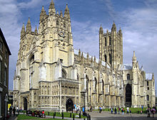
Kent’s geographical location between the Straits of Dover and London has influenced its architecture, as has its Cretaceous geology and its good farming land and fine building clays . Canterbury Cathedral is the United Kingdom’s metropolitan cathedral; it was founded in AD 598 . There are nine Anglo-Saxon churches in Kent .
Literature and publishing
Canterbury’s religious role gave rise to Chaucer’s Canterbury Tales, a key development in the English language . The father of novelist Charles Dickens worked at the Chatham Dockyard . Lord Northbourne hosted a biodynamic agriculture conference on his estate in 1939 .
Visual arts
J. M. W. Turner spent part of his childhood in the town of Margate in East Kent . The East Kent coast inspired many of his works, including some of his most famous seascapes . Kent has also been the home to artists including Frank Auerbach, Tracey Emin and Stass Paraskos .
Performing arts
The county’s largest theatre is the Marlowe Theatre in Canterbury . Music festivals that take place in Kent include Chilled in a Field Festival, Electric Gardens, Hop Farm Festival, In the Woods Festival, Lounge On The Farm and Smugglers Festival .
Kent etymology
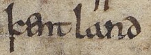
The name Kent is believed to be of British Celtic origin. The meaning has been explained as ‘coastal district,’ ‘corner-land’ or ‘land on the edge’ In Latin sources the area is called Cantia or Canticum.
Why visit Kent with Walkfo Travel Guide App?
 You can visit Kent places with Walkfo Kent to hear history at Kent’s places whilst walking around using the free digital tour app. Walkfo Kent has 15 places to visit in our interactive Kent map, with amazing history, culture & travel facts you can explore the same way you would at a museum or art gallery with information audio headset. With Walkfo, you can travel by foot, bike or bus throughout Kent, being in the moment, without digital distraction or limits to a specific walking route. Our historic audio walks, National Trust interactive audio experiences, digital tour guides for English Heritage locations are available at Kent places, with a AI tour guide to help you get the best from a visit to Kent & the surrounding areas.
“Curated content for millions of locations across the UK, with 15 audio facts unique to Kent places in an interactive Kent map you can explore.”
Walkfo: Visit Kent Places Map
15 tourist, history, culture & geography spots
Kent historic spots | Kent tourist destinations | Kent plaques | Kent geographic features |
| Walkfo Kent tourism map key: places to see & visit like National Trust sites, Blue Plaques, English Heritage locations & top tourist destinations in Kent | |||
Best Kent places to visit
Kent has places to explore by foot, bike or bus. Below are a selection of the varied Kent’s destinations you can visit with additional content available at the Walkfo Kent’s information audio spots:
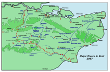 | Rivers of Kent Four major rivers drain the county of Kent, England. Four rivers drain four major rivers in Kent. Kent is home to four main rivers in the county. |
 | List of local nature reserves in Kent Kent is a county in the south-eastern corner of England. It is governed by Kent County Council, with twelve district councils. The chalk hills of the North Downs run from east to west through the county, with the wooded Weald to the south. |
Visit Kent plaques
 0
0
plaques
here Kent has 0 physical plaques in tourist plaque schemes for you to explore via Walkfo Kent plaques audio map when visiting. Plaques like National Heritage’s “Blue Plaques” provide visual geo-markers to highlight points-of-interest at the places where they happened – and Walkfo’s AI has researched additional, deeper content when you visit Kent using the app. Experience the history of a location when Walkfo local tourist guide app triggers audio close to each Kent plaque. Currently No Physical Plaques.


 Trying to encourage visitors to Kent?