Welcome to Visit County Durham Places
The Walkfo guide to things to do & explore in County Durham
 Visit County Durham places using Walkfo for free guided tours of the best County Durham places to visit. A unique way to experience County Durham’s places, Walkfo allows you to explore County Durham as you would a museum or art gallery with audio guides.
Visiting County Durham Walkfo Preview
County Durham is a historic county in North East England . The ceremonial county spawned from the historic County Palatine of Durham in 1853 . The county town is the city of Durham . The largest settlement is Darlington, followed by Hartlepool and Stockton-on-Tees . When you visit County Durham, Walkfo brings County Durham places to life as you travel by foot, bike, bus or car with a mobile phone & headphones.
County Durham Places Overview: History, Culture & Facts about County Durham
Visit County Durham – Walkfo’s stats for the places to visit
With 9 audio plaques & County Durham places for you to explore in the County Durham area, Walkfo is the world’s largest heritage & history digital plaque provider. The AI continually learns & refines facts about the best County Durham places to visit from travel & tourism authorities (like Wikipedia), converting history into an interactive audio experience.
County Durham history
Anglian Kingdom of Bernicia
Around AD 547, an Angle named Ida founded the kingdom of Bernicia after spotting the defensive potential of a large rock at Bamburgh . Ida was able to forge, hold and consolidate the kingdom; although the native British tried to take back their land, the Angles triumphed .
Kingdom of Northumbria
In AD 604, Ida’s grandson Æthelfrith forcibly merged Bernicia (ruled from Bamburgh) and Deira to create the Kingdom of Northumbria . At its height, the kingdom stretched from the River Humber (from which the kingdom drew its name) to the Forth . Eventually, factional fighting and the rejuvenated strength of neighbouring kingdoms led to its decline . The arrival of the Vikings hastened this decline, and the Scandinavian raiders claimed the Deiran part of the kingdom in AD 867 .
City of Durham founded
In AD 995, St Cuthbert’s community settled at Dunholm (Durham) on a site that was defensively favourable due to the horseshoe-like path of the River Wear . Bishop Aldhun began procuring land in the Tees and Wear valleys in 1018 . In 1031, King Canute gave Staindrop to the Bishops . This territory continued to expand, and was eventually given the status of a liberty .
County Palatine of Durham

Matters regarding the bishopric of Durham came to a head in 1293 when the bishop and his steward failed to attend proceedings of quo warranto held by the justices of Northumberland . In effect it was a private shire, with the bishop appointing his own sheriff . The area eventually became known as the “County Palatine of Durham”
Early administration

The historic boundaries of County Durham included a main body covering the catchment of the Pennines in the west, the River Tees in the south, the North Sea in the east and the Rivers Tyne and Derwent in the north. The county palatinate also had a number of liberties: the Bedlingtonshire, Islandshire and Norhamshire exclaves within Northumberland, and the Craikshire exclave within the North Riding of Yorkshire. In 1831 the county covered an area of 679,530 acres (2,750.0 km) and had a population of 253,910. These exclaves were included as part of the county for parliamentary electoral purposes until 1832, and for judicial and local-government purposes until the coming into force of the Counties (Detached Parts) Act 1844, which merged most remaining exclaves with their surrounding county. The boundaries of the county proper remained in use for administrative and ceremonial purposes until the 1972 Local Government Act. Following the Battle of Hastings, William the Conqueror appointed Copsig as Earl of Northumbria, thereby bringing what would become County Durham under Copsig’s control. Copsig was, just a few weeks later, killed in Newburn. Having already being previously offended by the appointment of a non-Northumbrian as Bishop of Durham in 1042, the people of the region became increasingly rebellious. In response, in January 1069, William despatched a large Norman army, under the command of Robert de Comines, to Durham City. The army, believed to consist of 700 cavalry (about one-third of the number of Norman knights who had participated in the Battle of Hastings), entered the city, whereupon they were attacked, and defeated, by a Northumbrian assault force. The Northumbrians wiped out the entire Norman army, including Comines, all except for one survivor, who was allowed to take the news of this defeat back. Following the Norman slaughter at the hands of the Northumbrians, resistance to Norman rule spread throughout Northern England, including a similar uprising in York. William The Conqueror subsequently (and successfully) attempted to halt the northern rebellions by unleashing the notorious Harrying of the North (1069–1070). Because William’s main focus during the harrying was on Yorkshire, County Durham was largely spared the Harrying. The best remains of the Norman period include Durham Cathedral and Durham Castle, and several parish churches, such as St Laurence Church in Pittington. The Early English period has left the eastern portion of the cathedral, the churches of Darlington, Hartlepool, and St Andrew, Auckland, Sedgefield, and portions of a few other churches. Until the 15th century, the most important administrative officer in the Palatinate was the steward. Other officers included the sheriff, the coroners, the Chamberlain and the chancellor. The palatine exchequer originated in the 12th century. The palatine assembly represented the whole county, and dealt chiefly with fiscal questions. The bishop’s council, consisting of the clergy, the sheriff and the barons, regulated judicial affairs, and later produced the Chancery and the courts of Admiralty and Marshalsea. The prior of Durham ranked first among the bishop’s barons. He had his own court, and almost exclusive jurisdiction over his men. A UNESCO site describes the role of the Prince-Bishops in Durham, the “buffer state between England and Scotland”:From 1075, the Bishop of Durham became a Prince-Bishop, with the right to raise an army, mint his own coins, and levy taxes. As long as he remained loyal to the king of England, he could govern as a virtually autonomous ruler, reaping the revenue from his territory, but also remaining mindful of his role of protecting England’s northern frontier. A report states that the Bishops also had the authority to appoint judges and barons and to offer pardons. There were ten palatinate barons in the 12th century, most importantly the Hyltons of Hylton Castle, the Bulmers of Brancepeth, the Conyers of Sockburne, the Hansards of Evenwood, and the Lumleys of Lumley Castle. The Nevilles owned large estates in the county. John Neville, 3rd Baron Neville de Raby rebuilt Raby Castle, their principal seat, in 1377. Edward I’s quo warranto proceedings of 1293 showed twelve lords enjoying more or less extensive franchises under the bishop. The repeated efforts of the Crown to check the powers of the palatinate bishops culminated in 1536 in the Act of Resumption, which deprived the bishop of the power to pardon offences against the law or to appoint judicial officers. Moreover, indictments and legal processes were in future to run in the name of the king, and offences to be described as against the peace of the king, rather than that of the bishop. In 1596 restrictions were imposed on the powers of the chancery, and in 1646 the palatinate was formally abolished. It was revived, however, after the Restoration, and continued with much the same power until 5 July 1836, when the Durham (County Palatine) Act 1836 provided that the palatine jurisdiction should in future be vested in the Crown. During the 15th-century Wars of the Roses, Henry VI passed through Durham. On the outbreak of the Great Rebellion in 1642 Durham inclined to support the cause of the Parliament, and in 1640 the high sheriff of the palatinate guaranteed to supply the Scottish army with provisions during their stay in the county. In 1642 the Earl of Newcastle formed the western counties into an association for the King’s service, but in 1644 the palatinate was again overrun by a Scottish army, and after the Battle of Marston Moor (2 July 1644) fell entirely into the hands of the parliament. In 1614, a bill was introduced in parliament for securing representation to the county and city of Durham and the borough of Barnard Castle. The bishop strongly opposed the proposal as an infringement of his palatinate rights, and the county was first summoned to return members to parliament in 1654. After the Restoration of 1660 the county and city returned two members each. In the wake of the Reform Act of 1832 the county returned two members for two divisions, and the boroughs of Gateshead, South Shields and Sunderland acquired representation. The bishops lost their secular powers in 1836. The boroughs of Darlington, Stockton and Hartlepool returned one member each from 1868 until the Redistribution Act of 1885. ‘Durham Castle and Cathedral’ is a designated UNESCO World Heritage Site. Other attractions in the County include; Auckland Castle, North of England Lead Mining Museum and Beamish Museum.
Modern government
The Municipal Corporations Act 1835 reformed the municipal boroughs of Durham, Stockton on Tees and Sunderland . In 1875, Jarrow was incorporated as a municipal borough, as was West Hartlepool in 1887 . At a county level, the Local Government Act 1888 reorganised local government throughout England and Wales . Most of the county came under control of the newly formed Durham County Council in an area known as an administrative county . However, for purposes other than local government, the county boroughs continued to form a single county to which the Crown appointed a Lord Lieutenant of Durham . Over its existence, the administrative county lost territory .
County Durham economy & business
Economic output
The chart and table summarise unadjusted gross value added (GVA) in millions of pounds sterling for County Durham across 3 industries at current basic prices from 1995 to 2004 .
Businesses
Phileas Fogg snacks are made by the United Biscuits subsidiary KP Snacks in Consett on the Number One Industrial Estate . The LG Philips Displays cathode ray tube factory at Carrville, Durham was the second largest employer in the north east after Nissan, before the company went bankrupt in 2006 .
County Durham etymology
The ceremonial county is officially named Durham, but the county has long been commonly known as County Durham. The 2009 structural change legislation created the present unitary council (that covers a large part – but not all – of the ceremonial county) refers to “the county of County Durham” and names the new unitary district “County Durham” too. The council retains the name as Durham County Council.
County Durham geography / climate
Geology
County Durham is underlain by Carboniferous rocks in the west . Permian and Triassic strata overlie these older rocks in the east . These sedimentary sequences have been cut by igneous dykes and sills .
Climate
The following climate figures were gathered at the Durham weather station between 1981 and 2010: Climate data gathered between 1981-2010 . The weather station was used to gather data from 1981 to 2010 .
North Pennines
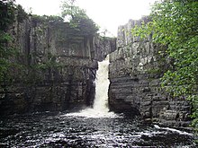
The highest point (county top) of historic County Durham is the trig point (not the summit) of Burnhope Seat, height 746 metres (2,448 ft) The county contains a sizeable area of the North Pennines, designated an Area of Outstanding Natural Beauty . The two main dales of County Durham (Teesdale and Weardale) and the surrounding fells are excellent hillwalking country .
Birds
152 species of birds are recorded as breeding; however, not all are considered regular breeders . 152 species are recorded to be breeding, but not all of them are considered ‘regular breeders’
Why visit County Durham with Walkfo Travel Guide App?
 You can visit County Durham places with Walkfo County Durham to hear history at County Durham’s places whilst walking around using the free digital tour app. Walkfo County Durham has 9 places to visit in our interactive County Durham map, with amazing history, culture & travel facts you can explore the same way you would at a museum or art gallery with information audio headset. With Walkfo, you can travel by foot, bike or bus throughout County Durham, being in the moment, without digital distraction or limits to a specific walking route. Our historic audio walks, National Trust interactive audio experiences, digital tour guides for English Heritage locations are available at County Durham places, with a AI tour guide to help you get the best from a visit to County Durham & the surrounding areas.
“Curated content for millions of locations across the UK, with 9 audio facts unique to County Durham places in an interactive County Durham map you can explore.”
Walkfo: Visit County Durham Places Map
9 tourist, history, culture & geography spots
County Durham historic spots | County Durham tourist destinations | County Durham plaques | County Durham geographic features |
| Walkfo County Durham tourism map key: places to see & visit like National Trust sites, Blue Plaques, English Heritage locations & top tourist destinations in County Durham | |||
Best County Durham places to visit
County Durham has places to explore by foot, bike or bus. Below are a selection of the varied County Durham’s destinations you can visit with additional content available at the Walkfo County Durham’s information audio spots:
 | Hamsterley Forest Hamsterley Forest is the largest forest in County Durham. It covers more than 2,000 hectares (4,900 acres) Recreational activities are focused at the eastern end of the forest. |
Visit County Durham plaques
 0
0
plaques
here County Durham has 0 physical plaques in tourist plaque schemes for you to explore via Walkfo County Durham plaques audio map when visiting. Plaques like National Heritage’s “Blue Plaques” provide visual geo-markers to highlight points-of-interest at the places where they happened – and Walkfo’s AI has researched additional, deeper content when you visit County Durham using the app. Experience the history of a location when Walkfo local tourist guide app triggers audio close to each County Durham plaque. Currently No Physical Plaques.


 Trying to encourage visitors to County Durham?