Welcome to Visit Dagenham Places
The Walkfo guide to things to do & explore in Dagenham
 Visit Dagenham places using Walkfo for free guided tours of the best Dagenham places to visit. A unique way to experience Dagenham’s places, Walkfo allows you to explore Dagenham as you would a museum or art gallery with audio guides.
Visiting Dagenham Walkfo Preview
Dagenham is located 11.5 miles (18.5 km) east of Charing Cross. It was historically a rural parish in the Becontree Hundred of Essex, stretching from Hainault Forest in the north to the River Thames in the south. It remained mostly undeveloped until 1921, when the London County Council began construction of the large estate of Becontrees. The population significantly increased as people moved to the new housing in the early 20th century. When you visit Dagenham, Walkfo brings Dagenham places to life as you travel by foot, bike, bus or car with a mobile phone & headphones.
Dagenham Places Overview: History, Culture & Facts about Dagenham
Visit Dagenham – Walkfo’s stats for the places to visit
With 77 audio plaques & Dagenham places for you to explore in the Dagenham area, Walkfo is the world’s largest heritage & history digital plaque provider. The AI continually learns & refines facts about the best Dagenham places to visit from travel & tourism authorities (like Wikipedia), converting history into an interactive audio experience.
Dagenham history
Toponymy
Dagenham first appeared in a document (as Dæccanhaam) in a charter of Barking Abbey dating from 666 AD. The name almost certainly originated with a small farmstead, the “ham” or farm of a man called Daecca.
Manor of Barking
The parish of Dagenham was formed in the medieval period to serve the people of Barking, which was owned by the Nunnery of the Barking Abbey. The area held by the manors declined over time, but the parish boundaries remained constant.
Pre-urban landscape
Dagenham was laid out on a N-S axis to give it a share of the marshes by the river, the agricultural land in the centre and the woods and commons on the poorer soils on the high ground in the north. It included a significant part of the now mostly lost Hainault Forest.
Dagenham Breach
South of Dagenham was a low-lying area subject to periodic flooding from the Thames. Dutch engineers built defences and a flood gate on the Beam River being built in the 17th century. In 1707 an exceptionally high tide swept away fourteen feet of embankment and flooded over 1,000 acres of land. A further flood occurred in 1718 after which, under an act of parliament, over £40,000 of public money was spent on successfully closing the breach. The closure of the gap left behind a large lake, also known as “Dagenham Breach”
Whitebait Dinners
Dagenham was formerly home to the famous annual whitebait feast. The custom appears to have been started by the King’s Commissioner of Works to celebrate the breach in the seawall around 1714–20.
Economic development
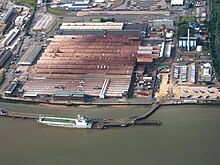
Ford Motor Company moved to Dagenham from Manchester in 1931. It was already the location of supplier Briggs Motorway Bodies. At its peak the plant had 4,000,000 square feet (370,000 m) of floor space. Full production was discontinued in 2002 due to overcapacity in Europe and the difficulty of upgrading the 60-year-old site.
Market gardens to suburban estate

In 1205 Dagenham was large enough to have a chaplain, and the Parish Church of St Peter and St Paul was probably built at around that time. In 1854, the London, Tilbury and Southend Railway was built through the south of the village, near the River Thames. In the 1920s, building of the Becontree estate by the London County Council began in the early 1920s. In 1932 the electrified District line of the London Underground was extended to Upminster through the village.
Dagenham culture & places
Valence House, in Becontree Avenue, is the only surviving of the five manor houses of Dagenham. Dating back to the 13th century, it is sited in parkland and there is a moat around part of it. The Fanshawe collection is “one of the best collections of gentry portraits in the country and is of international importance”
Media
Barking & Dagenham Post is printed weekly and also published online. It is printed in the Barking News and is published by The Barking Post.
Dagenham geography / climate

Dagenham is 11.5 miles (18.5 km) east of Charing Cross in Central London. It is adjacent to Barking to the west, Romford to northeast and Hornchurch to the east.
Why visit Dagenham with Walkfo Travel Guide App?
 You can visit Dagenham places with Walkfo Dagenham to hear history at Dagenham’s places whilst walking around using the free digital tour app. Walkfo Dagenham has 77 places to visit in our interactive Dagenham map, with amazing history, culture & travel facts you can explore the same way you would at a museum or art gallery with information audio headset. With Walkfo, you can travel by foot, bike or bus throughout Dagenham, being in the moment, without digital distraction or limits to a specific walking route. Our historic audio walks, National Trust interactive audio experiences, digital tour guides for English Heritage locations are available at Dagenham places, with a AI tour guide to help you get the best from a visit to Dagenham & the surrounding areas.
“Curated content for millions of locations across the UK, with 77 audio facts unique to Dagenham places in an interactive Dagenham map you can explore.”
Walkfo: Visit Dagenham Places Map
77 tourist, history, culture & geography spots
Dagenham historic spots | Dagenham tourist destinations | Dagenham plaques | Dagenham geographic features |
| Walkfo Dagenham tourism map key: places to see & visit like National Trust sites, Blue Plaques, English Heritage locations & top tourist destinations in Dagenham | |||
Best Dagenham places to visit
Dagenham has places to explore by foot, bike or bus. Below are a selection of the varied Dagenham’s destinations you can visit with additional content available at the Walkfo Dagenham’s information audio spots:

East London
East London is a popularly and informally defined part of London. It is east of the ancient City of London and north of the River Thames. It comprises the London boroughs of Barking and Dagenham, Hackney, Havering, Newham, Redbridge, Tower Hamlets and Waltham Forest.
Rush Green, London
Rush Green is a suburban area in Romford in East London. It straddles the boundary of Barking and Dagenham and Havering. It is located 13.5 miles (22 km) east-northeast of Charing Cross.
Visit Dagenham plaques
 5
5
plaques
here Dagenham has 5 physical plaques in tourist plaque schemes for you to explore via Walkfo Dagenham plaques audio map when visiting. Plaques like National Heritage’s “Blue Plaques” provide visual geo-markers to highlight points-of-interest at the places where they happened – and Walkfo’s AI has researched additional, deeper content when you visit Dagenham using the app. Experience the history of a location when Walkfo local tourist guide app triggers audio close to each Dagenham plaque. Explore Plaques & History has a complete list of Hartlepool’s plaques & Hartlepool history plaque map.


 Trying to encourage visitors to Dagenham?