Welcome to Visit Cardiff Places
The Walkfo guide to things to do & explore in Cardiff
 Visit Cardiff places using Walkfo for free guided tours of the best Cardiff places to visit. A unique way to experience Cardiff’s places, Walkfo allows you to explore Cardiff as you would a museum or art gallery with audio guides.
Visiting Cardiff Walkfo Preview
Cardiff is the capital and largest city of Wales . It forms a principal area, officially known as the City and County of Cardiff (Welsh: Dinas a Sir Caerdydd) The city is the eleventh-largest in the United Kingdom . A small town until the early 19th century, its prominence as a port for coal when mining began in the region helped its expansion . In 1905 it was ranked as a city and proclaimed capital of Wales in 1955 . When you visit Cardiff, Walkfo brings Cardiff places to life as you travel by foot, bike, bus or car with a mobile phone & headphones.
Cardiff Places Overview: History, Culture & Facts about Cardiff
Visit Cardiff – Walkfo’s stats for the places to visit
With 269 audio plaques & Cardiff places for you to explore in the Cardiff area, Walkfo is the world’s largest heritage & history digital plaque provider. The AI continually learns & refines facts about the best Cardiff places to visit from travel & tourism authorities (like Wikipedia), converting history into an interactive audio experience.
Cardiff history
Origins
Archaeological evidence from sites in and around Cardiff show that people had settled in the area by at least around 6000 BC, during the early Neolithic; about 1,500 years before either Stonehenge or the Great Pyramid of Giza was completed . A Bronze Age tumuli is at the summit of the Garth, within the county’s northern boundary .
Norman occupation and Middle Ages
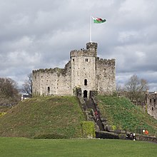
In 1081 William I began work on the castle keep within the walls of the old Roman fort . A town grew up under the castle, consisting mainly of settlers from England . Cardiff had a population of between 1,500 and 2,000 in the Middle Ages – a normal size for a Welsh town .
County town of Glamorganshire

In 1536, the Laws in Wales Acts 1535–1542 led to the creation of Glamorganshire . In 1538, Henry VIII closed Cardiff’s Dominican and Franciscan friaries, whose remains were used as building materials . Cardiff became a Free Borough in 1542 and further Royal Charters were granted to it by Elizabeth I in 1600 and James I in 1608 . A disastrous flood in the Bristol Channel on 30 January 1607 (now believed to have been a tidal wave) ruined St Mary’s Parish Church .
Building the docks
In 1793, John Crichton-Stuart, 2nd Marquess of Bute was born in Cardiff . He spent his life building the Cardiff docks and was hailed as “the creator of modern Cardiff” By the 1881 census, Cardiff had overtaken Merthyr and Swansea to become the largest town in Wales .
County Borough of Cardiff
Cardiff became a county borough on 1 April 1889 under the Local Government Act 1888 . The town had grown rapidly and had a population of over 123,000 . It retained its county borough status until 1974 .
City and capital city status
King Edward VII granted Cardiff city status on 28 October 1905 . It acquired a Roman Catholic cathedral in 1916 . The city was recognised as the capital city of Wales on 20 December 1955 .
Cardiff economy & business
Shopping

Most of Cardiff’s shopping portfolio is in the city centre around Queen Street, St Mary Street and High Street . A £675 million regeneration programme for Cardiff’s St. David’s Centre was completed in 2009, providing a total of 1,400,000 sq ft (130,000 m) of shopping space . The Castle Quarter is a commercial area in the north of Cardiff, which includes some of the Victorian and Edwardian arcades .
Cardiff etymology
The anglicised Cardiff is derived from Caerdyf, with the Welsh f [v] borrowed as ff /f/, as also happens in Taff (from Welsh Taf) and Llandaff. The name Cardiff may derive from *Caer-Didi, a name supposedly given in honour of Aulus Didius Gallus.
Cardiff geography / climate
The centre of Cardiff is relatively flat and bounded by hills to the east, north and west. The highest point in the local authority area is Garth Hill, 307 metres (1,007 feet) above sea level. Cardiff lies near the Glamorgan Heritage Coast, stretching westward from Penarth and Barry with striped yellow-blue Jurassic limestone cliffs.
Why visit Cardiff with Walkfo Travel Guide App?
 You can visit Cardiff places with Walkfo Cardiff to hear history at Cardiff’s places whilst walking around using the free digital tour app. Walkfo Cardiff has 269 places to visit in our interactive Cardiff map, with amazing history, culture & travel facts you can explore the same way you would at a museum or art gallery with information audio headset. With Walkfo, you can travel by foot, bike or bus throughout Cardiff, being in the moment, without digital distraction or limits to a specific walking route. Our historic audio walks, National Trust interactive audio experiences, digital tour guides for English Heritage locations are available at Cardiff places, with a AI tour guide to help you get the best from a visit to Cardiff & the surrounding areas.
“Curated content for millions of locations across the UK, with 269 audio facts unique to Cardiff places in an interactive Cardiff map you can explore.”
Walkfo: Visit Cardiff Places Map
269 tourist, history, culture & geography spots
Cardiff historic spots | Cardiff tourist destinations | Cardiff plaques | Cardiff geographic features |
| Walkfo Cardiff tourism map key: places to see & visit like National Trust sites, Blue Plaques, English Heritage locations & top tourist destinations in Cardiff | |||
Best Cardiff places to visit
Cardiff has places to explore by foot, bike or bus. Below are a selection of the varied Cardiff’s destinations you can visit with additional content available at the Walkfo Cardiff’s information audio spots:
 | St Andrews United Reformed Church, Roath St. Andrew’s United Reformed Church is located in the Roath area of Cardiff, Wales. The church is situated on the corner of Wellfield Road and Malborough Road. |
 | St Martin’s Church, Roath St Martin’s Church is an Anglican church on Albany Road in Roath, Cardiff, Wales. It is located in the Welsh capital. |
 | The Gate Arts Centre The Gate Arts Centre (often just referred to as the Gate) is an arts centre and community building located in Keppoch Street, Roath, Cardiff. The Gate is in a Grade 2 listed building (in what was formerly the Plasnewydd Presbyterian Church) |
 | St Anne’s Church, Roath St Anne’s Church, Roath is a disused church on the corner of Snipe Street and Croft Street, in Roath, Cardiff, Wales. It closed in 2015 after 128 years of worship. |
 | Penylan Penylan is a district and community in the east of Cardiff, Wales. Known for its Edwardian period houses and spacious tree lined roads and avenues. It is one of the most affluent districts of Cardiff. |
 | St Margaret’s Church, Roath St Margaret’s Church (dedicated to St Margaret of Antioch) is a nineteenth-century Church in Wales parish church in the suburb of Roath, Cardiff, Wales. It includes the mausoleum of the Marquises of Bute. |
 | Church of St Andrew & St Teilo, Cathays The Church of St Andrew and St Teilo is a Church in Wales church. It is located in Cathays, Cardiff, Wales. It was built in the 1930s and is located on the outskirts of Cardiff. |
 | Parkminster United Reformed Church, Roath Parkminster United Reformed Church is located in Roath, Cardiff. It is located on the site of the Church of Wales, Parkminster, Wales. The church is currently located in the Welsh city of Cardiff. |
 | Tredegarville Baptist Church Tredegarville Baptist Church is a Baptist chapel in Roath, Cardiff. It was established to reach Roman Catholics with the Gospel. |
 | Tredegarville Tredegarville was the name given to an upper class area of streets and villas in Cardiff, Wales, developed during the second half of the 19th century. The area is now part of Roath. |
Visit Cardiff plaques
 28
28
plaques
here Cardiff has 28 physical plaques in tourist plaque schemes for you to explore via Walkfo Cardiff plaques audio map when visiting. Plaques like National Heritage’s “Blue Plaques” provide visual geo-markers to highlight points-of-interest at the places where they happened – and Walkfo’s AI has researched additional, deeper content when you visit Cardiff using the app. Experience the history of a location when Walkfo local tourist guide app triggers audio close to each Cardiff plaque. Explore Plaques & History has a complete list of Hartlepool’s plaques & Hartlepool history plaque map.


 Trying to encourage visitors to Cardiff?