Welcome to Visit Edinburgh Places
The Walkfo guide to things to do & explore in Edinburgh
 Visit Edinburgh places using Walkfo for free guided tours of the best Edinburgh places to visit. A unique way to experience Edinburgh’s places, Walkfo allows you to explore Edinburgh as you would a museum or art gallery with audio guides.
Visiting Edinburgh Walkfo Preview
Edinburgh is the capital city of Scotland and one of its 32 council areas. Historically part of the county of Midlothian, it is located in Lothian on the southern shore of the Firth of Forth. Edinburgh is Scotland’s second-most populous city and the seventh-most in the United Kingdom. It is the seat of the Scottish Government, the Scottish Parliament and the highest courts in Scotland. The city’s Palace of Holyroodhouse is the official residence of the monarch. When you visit Edinburgh, Walkfo brings Edinburgh places to life as you travel by foot, bike, bus or car with a mobile phone & headphones.
Edinburgh Places Overview: History, Culture & Facts about Edinburgh
Visit Edinburgh – Walkfo’s stats for the places to visit
 With 483 audio plaques & Edinburgh places for you to explore in the Edinburgh area, Walkfo is the world’s largest heritage & history digital plaque provider. The AI continually learns & refines facts about the best Edinburgh places to visit from travel & tourism authorities (like Wikipedia), converting history into an interactive audio experience.
Edinburgh history
Early history

The earliest known human habitation in the Edinburgh area was at Cramond, where evidence was found of a Mesolithic camp site dated to 8500 BC. Traces of later Bronze Age and Iron Age settlements have been found on Castle Rock, Arthur’s Seat, Craiglockhart Hill and the Pentland Hills. Edinburgh was largely in English hands from 1291 to 1314 and from 1333 to 1341, during the Wars of Scottish Independence.
17th century
In the 17th century, Edinburgh’s boundaries were still defined by the city’s defensive town walls. Buildings of 11 storeys or more were common, and have been described as forerunners of the modern-day skyscraper. In 1611 an act of parliament created the High Constables of Edinburgh to keep order in the city, thought to be the oldest statutory police force in the world.
18th century

By the first half of the 18th century, Edinburgh was described as one of Europe’s most densely populated, overcrowded and unsanitary towns. The city was at the heart of the Scottish Enlightenment, when thinkers like David Hume, Adam Smith, James Hutton and Joseph Black were familiar figures in its streets. Edinburgh was briefly occupied by the Jacobite “Highland Army” before its march into England.
19th and 20th centuries

By 1821, Edinburgh had been overtaken by Glasgow as Scotland’s largest city. The city centre between Princes Street and George Street became a major commercial and shopping district. The Old Town became an increasingly dilapidated, overcrowded slum with high mortality rates. Since the 1990s a new financial district has grown mainly on demolished railway property to the west of the castle.
Edinburgh culture & places
Festivals and celebrations
Edinburgh hosts a series of festivals that run between the end of July and early September each year. Best known of these events are the Edinburgh Festival Fringe, the Edinburgh International Festival and the Edinburgh Art Festival. In 2017, nearly 3400 different shows were staged in 300 venues across the city. The Edinburgh Military Tattoo occupies the Castle Esplanade every night for three weeks each August.
Music, theatre and film
Usher Hall is Edinburgh’s premier venue for classical music. It was the venue for the Eurovision Song Contest 1972. Edinburgh has two repertory cinemas, the Edinburgh Filmhouse and The Cameo.
Media
The main local newspaper is the Edinburgh Evening News. The city has two commercial radio stations: Forth 1, a station which broadcasts mainstream chart music, and Forth 2 on medium wave which plays classic hits. There are no television stations based in the city.
Museums, libraries and galleries

Edinburgh contains Scotland’s three National Galleries of Art as well as numerous smaller art galleries. Edinburgh Zoo is home to two giant pandas, Tian Tian and Yang Guang, on loan from the People’s Republic of China. Edinburgh is also home to The Royal Yacht Britannia, decommissioned in 1997.
Shopping
Princes Street is the main shopping area in the city centre, with souvenir shops, chain stores such as Boots the Chemist, Edinburgh Woollen Mill, H&M and Jenners. George Street, north of Princes St, is the preferred location for some upmarket shops and independent stores. The redeveloped St James Quarter opened its doors in June 2021.
Edinburgh etymology
“Edin”, the root of the city’s name, derives from Eidyn, the name for this region in Cumbric, the Brittonic Celtic language formerly spoken there. Eidyn was conquered by the Angles of Bernicia in 7th century and later occupied by the Scots in 10th century.
Edinburgh geography / climate
Cityscape
Edinburgh lies on the southern shore of the Firth of Forth and 26 miles inland. The city centre is 2+1/2 miles (4.0 km) southwest of the shoreline of Leith. The modern city is often said to be built on seven hills, namely Calton Hill, Corstorphine Hill, Craiglockhart Hill, Braid Hill, Blackford Hill, Arthur’s Seat and the Castle Rock, giving rise to allusions to the seven hills of Rome.
Areas
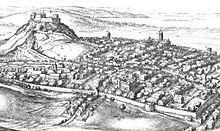
Edinburgh includes former towns and villages that retain much of their original character as settlements in existence before they were absorbed into the expanding city of the nineteenth and twentieth centuries. Many areas, such as Dalry, contain residences that are multi-occupancy buildings known as tenements, although the more southern and western parts of the city have traditionally been less built-up with a greater number of detached and semi-detached villas. The historic centre of Edinburgh is divided in two by the broad green swathe of Princes Street Gardens. To the south, the view is dominated by Edinburgh Castle, built high on Castle Rock, and the long sweep of the Old Town descending towards Holyrood Palace. To the north lie Princes Street and the New Town. The West End includes the financial district, with insurance and banking offices as well as the Edinburgh International Conference Centre. Edinburgh’s Old and New Towns were listed as a UNESCO World Heritage Site in 1995 in recognition of the unique character of the Old Town with its medieval street layout and the planned Georgian New Town, including the adjoining Dean Village and Calton Hill areas. There are over 4,500 listed buildings within the city, a higher proportion relative to area than any other city in the United Kingdom. The castle is perched on top of a rocky crag (the remnant of an extinct volcano) and the Royal Mile runs down the crest of a ridge from it terminating at Holyrood Palace. Minor streets (called closes or wynds) lie on either side of the main spine forming a herringbone pattern. Due to space restrictions imposed by the narrowness of this landform, the Old Town became home to some of the earliest “high rise” residential buildings. Multi-storey dwellings known as lands were the norm from the 16th century onwards with ten and eleven storeys being typical and one even reaching fourteen or fifteen storeys. Numerous vaults below street level were inhabited to accommodate the influx of incomers, particularly Irish immigrants, during the Industrial Revolution. The street has several fine public buildings such as St Giles’ Cathedral, the City Chambers and the Law Courts. Other places of historical interest nearby are Greyfriars Kirkyard and Mary King’s Close. The Grassmarket, running deep below the castle is connected by the steep double terraced Victoria Street. The street layout is typical of the old quarters of many Northwestern European cities. The New Town was an 18th-century solution to the problem of an increasingly crowded city which had been confined to the ridge sloping down from the castle. In 1766 a competition to design a “New Town” was won by James Craig, a 27-year-old architect. The plan was a rigid, ordered grid, which fitted in well with Enlightenment ideas of rationality. The principal street was to be George Street, running along the natural ridge to the north of what became known as the “Old Town”. To either side of it are two other main streets: Princes Street and Queen Street. Princes Street has become Edinburgh’s main shopping street and now has few of its Georgian buildings in their original state. The three main streets are connected by a series of streets running perpendicular to them. The east and west ends of George Street are terminated by St Andrew Square and Charlotte Square respectively. The latter, designed by Robert Adam, influenced the architectural style of the New Town into the early 19th century. Bute House, the official residence of the First Minister of Scotland, is on the north side of Charlotte Square. The hollow between the Old and New Towns was formerly the Nor Loch, which was created for the town’s defence but came to be used by the inhabitants for dumping their sewage. It was drained by the 1820s as part of the city’s northward expansion. Craig’s original plan included an ornamental canal on the site of the loch, but this idea was abandoned. Soil excavated while laying the foundations of buildings in the New Town was dumped on the site of the loch to create the slope connecting the Old and New Towns known as The Mound. In the middle of the 19th century the National Gallery of Scotland and Royal Scottish Academy Building were built on The Mound, and tunnels for the railway line between Haymarket and Waverley stations were driven through it. The Southside is a residential part of the city, which includes the districts of St Leonards, Marchmont, Morningside, Newington, Sciennes, the Grange and Blackford. The Southside is broadly analogous to the area covered formerly by the Burgh Muir, and was developed as a residential area after the opening of the South Bridge in the 1780s. The Southside is particularly popular with families (many state and private schools are here), young professionals and students (the central University of Edinburgh campus is based around George Square just north of Marchmont and the Meadows), and Napier University (with major campuses around Merchiston and Morningside). The area is also well provided with hotel and “bed and breakfast” accommodation for visiting festival-goers. These districts often feature in works of fiction. For example, Church Hill in Morningside, was the home of Muriel Spark’s Miss Jean Brodie, and Ian Rankin’s Inspector Rebus lives in Marchmont and works in St Leonards. Leith was historically the port of Edinburgh, an arrangement of unknown date that was confirmed by the royal charter Robert the Bruce granted to the city in 1329. The port developed a separate identity from Edinburgh, which to some extent it still retains, and it was a matter of great resentment when the two burghs merged in 1920 into the City of Edinburgh. Even today the parliamentary seat is known as “Edinburgh North and Leith”. The loss of traditional industries and commerce (the last shipyard closed in 1983) resulted in economic decline. The Edinburgh Waterfront development has transformed old dockland areas from Leith to Granton into residential areas with shopping and leisure facilities and helped rejuvenate the area. With the redevelopment, Edinburgh has gained the business of cruise liner companies which now provide cruises to Norway, Sweden, Denmark, Germany, and the Netherlands. The coastal suburb of Portobello is characterised by Georgian villas, Victorian tenements, a beach and promenade and cafés, bars, restaurants and independent shops. There are rowing and sailing clubs and a restored Victorian swimming pool, including Turkish baths. The urban area of Edinburgh is almost entirely within the City of Edinburgh Council boundary, merging with Musselburgh in East Lothian. Towns within easy reach of the city boundary include Haddington, Tranent, Prestonpans, Dalkeith, Bonnyrigg, Loanhead, Penicuik, Broxburn, Livingston and Dunfermline. Edinburgh lies at the heart of the Edinburgh & South East Scotland City region with a population in 2014 of 1,339,380.
Climate
Like most of Scotland, Edinburgh has a cool, temperate, maritime climate. The city’s proximity to the sea mitigates any large variations in temperature or extremes of climate. Winter daytime temperatures rarely fall below freezing while summer temperatures are moderate. The highest temperature recorded in the city was 31.6 °C (88.9 °F) on 25 July 2019 at Gogarbank.
Why visit Edinburgh with Walkfo Travel Guide App?
 You can visit Edinburgh places with Walkfo Edinburgh to hear history at Edinburgh’s places whilst walking around using the free digital tour app. Walkfo Edinburgh has 483 places to visit in our interactive Edinburgh map, with amazing history, culture & travel facts you can explore the same way you would at a museum or art gallery with information audio headset. With Walkfo, you can travel by foot, bike or bus throughout Edinburgh, being in the moment, without digital distraction or limits to a specific walking route. Our historic audio walks, National Trust interactive audio experiences, digital tour guides for English Heritage locations are available at Edinburgh places, with a AI tour guide to help you get the best from a visit to Edinburgh & the surrounding areas.
“Curated content for millions of locations across the UK, with 483 audio facts unique to Edinburgh places in an interactive Edinburgh map you can explore.”
Walkfo: Visit Edinburgh Places Map
483 tourist, history, culture & geography spots
Edinburgh historic spots | Edinburgh tourist destinations | Edinburgh plaques | Edinburgh geographic features |
| Walkfo Edinburgh tourism map key: places to see & visit like National Trust sites, Blue Plaques, English Heritage locations & top tourist destinations in Edinburgh | |||
Best Edinburgh places to visit
Edinburgh has places to explore by foot, bike or bus. Below are a selection of the varied Edinburgh’s destinations you can visit with additional content available at the Walkfo Edinburgh’s information audio spots:
 | Holy Corner Holy Corner is a colloquial name for a small area of Edinburgh, Scotland. It is part of Burghmuirhead, itself part of the lands of Greenhill. Holy Corner lies between Bruntsfield and Morningside. |
 | Golfers Land The Golfers Land is a site on the Royal Mile in Edinburgh, Scotland dating to around 1681. The site gets its name from the town house of John Paterson, said to have been the teammate of the Duke of Albany in what is often regarded as the first international golf contest. |
| The Canongate The Canongate is the main eastern section of Edinburgh’s Old Town. It began when David I of Scotland authorised Holyrood Abbey to found a burgh separate from Edinburgh between the Abbey and Edinburgh. The burgh gained its name from the route the canons took to Edinburgh. In 1636 the adjacent city of Edinburgh bought the feudal superiority of the canongate. |
 | Victoria Park, Edinburgh Victoria Park is a district in north Edinburgh south of Newhaven and lying between Trinity and Leith. The area was given Conservation Area status in March 1998. |
 | Dean Village Dean Village (from dene, meaning ‘deep valley’) is a former village immediately northwest of Edinburgh, Scotland. It was known as the “Water of Leith Village” and was a successful grain milling area for more than 800 years. |
 | Moray Estate The Moray Estate in Edinburgh was an exclusive early 19th century building venture. Built on an awkward and steeply sloping site, it is a masterpiece of urban planning. It has accommodated the rich and famous from its outset. |
| Stockbridge, Edinburgh Stockbridge is a suburb of Edinburgh, located north of the city centre. Originally a small outlying village, it was incorporated into the City of Edinburgh in the 19th century. The name is Scots stock brig from Anglic stocc brycg, meaning a timber bridge. The current “Stock Bridge” is a stone structure spanning the Water of Leith. |
| Merchiston Merchiston is a residential area around Merchiston Avenue in the south-west of Edinburgh, Scotland. The area is known as Merchiston, or Merchiston in the north-east of Edinburgh. |
| Edinburgh Edinburgh is the capital city of Scotland and one of its 32 council areas. Historically part of the county of Midlothian, it is located in Lothian on the southern shore of the Firth of Forth. Edinburgh is Scotland’s second-most populous city and the seventh-most in the United Kingdom. It is the seat of the Scottish Government, the Scottish Parliament and the highest courts in Scotland. The city’s Palace of Holyroodhouse is the official residence of the monarch. |
 | St James Quarter St James Quarter is a retail, lifestyle and residential district in Edinburgh. It is situated in the east end of the New Town. The district is a redevelopment on the site of the St James Centre which closed in October 2016. |
Visit Edinburgh plaques
 186
186
plaques
here Edinburgh has 186 physical plaques in tourist plaque schemes for you to explore via Walkfo Edinburgh plaques audio map when visiting. Plaques like National Heritage’s “Blue Plaques” provide visual geo-markers to highlight points-of-interest at the places where they happened – and Walkfo’s AI has researched additional, deeper content when you visit Edinburgh using the app. Experience the history of a location when Walkfo local tourist guide app triggers audio close to each Edinburgh plaque. Explore Plaques & History has a complete list of Hartlepool’s plaques & Hartlepool history plaque map.


 Trying to encourage visitors to Edinburgh?