Welcome to Visit Stalybridge Places
The Walkfo guide to things to do & explore in Stalybridge
 Visit Stalybridge places using Walkfo for free guided tours of the best Stalybridge places to visit. A unique way to experience Stalybridge’s places, Walkfo allows you to explore Stalybridge as you would a museum or art gallery with audio guides.
Visiting Stalybridge Walkfo Preview
Stalybridge is a town in Tameside, Greater Manchester, with a population of 23,731 at the 2011 Census. Historically part of Cheshire, it is 8 miles (12.9 km) east of Manchester city centre and 6 miles (9.7 km) north-west of Glossop. Water-powered cotton mill was constructed in 1776, one of the first centres of textile manufacture during Industrial Revolution. When you visit Stalybridge, Walkfo brings Stalybridge places to life as you travel by foot, bike, bus or car with a mobile phone & headphones.
Stalybridge Places Overview: History, Culture & Facts about Stalybridge
Visit Stalybridge – Walkfo’s stats for the places to visit
With 81 audio plaques & Stalybridge places for you to explore in the Stalybridge area, Walkfo is the world’s largest heritage & history digital plaque provider. The AI continually learns & refines facts about the best Stalybridge places to visit from travel & tourism authorities (like Wikipedia), converting history into an interactive audio experience.
Stalybridge history
Early history
The earliest evidence of human activity in Stalybridge is a flint scraper from the late Neolithic/early Bronze Age. The settlement was originally called Stavelegh, which derives from the Old English staef leah, meaning “wood where the staves are got” Staley Hall was built in the late 16th century on the same site as an earlier hall of the Stayley family which dated from before 1343. Buckton Castle was probably built by one of the earls of Chester in 12th century.
Industrial Revolution

As Stayley expanded in the 18th century, it reached the banks of the River Tame. After the construction of a bridge in 1707, the settlement was commonly referred to as Stalybridge, meaning the bridge at Stayley. By the mid-18th century Stalybridge had a population of just 140. Farming and woolen spinning were the main means of subsistence at this time. In 1776, the town’s first water-powered mill for carding and spinning cotton was built at Rassbottom. In 1789, the town’s first spinning mill using the principle of Arkwright’s Water Frame was built. By 1793, steam power had been introduced to the Stalybridge cotton industry; by 1803 there were eight cotton mills in the growing town containing 76,000 spindles. The Huddersfield Narrow Canal was completed in 1811 and still runs through the town. The rapid growth of industry in Stalybridge was due to the introduction of machinery. This was, however, met with violent opposition. After the arrival of the Luddites in the area the doors of mills were kept locked day and night. Military aid was requested by the mill owners and a Scottish regiment under the Duke of Montrose was sent to the town. It was led by Captain Raines who made his headquarters at the Roe Cross Inn. The Luddite disturbances began in November 1811. Gangs of armed men destroyed power looms and fired mills. The disturbances in Stalybridge culminated with a night of violent rioting on 20 April 1812. The social unrest did not curb the growth of Stalybridge. By 1814, there were twelve factories and, by 1818, the number had increased to sixteen. The Industrial Revolution led to a rapid increase in the town’s population in the early part of the 19th century. The population of the town by 1823 was 5,500. In the following two years, partly because of an influx of Irish families seeking better wages, the population rose to 9,000. Stalybridge was among the first wave of towns to establish a Mechanics’ Institute with a view to educating the growing number of workers. Only a year after the establishment of Manchester Mechanics’ Institute, Stalybridge founded an Institute of its own. Its doors opened on 7 September 1825 on Shepley Street with a reading room on Queen Street. On 9 May 1828, the Stalybridge Police and Market Act received Royal Assent, establishing Stalybridge as an independent town with a board of 21 Commissioners. Every male over the age of 21 who was the occupier of a rateable property under the act was entitled to vote at the election of the Commissioners. On 30 December 1831, the town hall and market were officially opened. In 1833, the Commissioners set up the Stalybridge Police Force, the first of its kind in the country. By this year, the population of the town had reached 14,216 with 2.357 inhabited houses. In 1834, a second bridge was built over the Tame. It was downstream of Staley Bridge and constructed of iron. The second Chartist petition was presented to Parliament in April 1842. Stalybridge contributed 10,000 signatures. After the rejection of the petition the first general strike began in the coal mines of Staffordshire. The second phase of the strike originated in Stalybridge. A movement of resistance to the imposition of wage cuts in the mills, also known as the Plug Riots, it spread to involve nearly half a million workers throughout Britain and represented the biggest single exercise of working class strength in 19th century Britain. On 13 August 1842, there was a strike at Bayley’s Cotton Mill in Stalybridge and roving cohorts of operatives carried the stoppage first to the whole area of Stalybridge and Ashton, then to Manchester, and subsequently to towns adjacent to Manchester, using as much force as was necessary to bring mills to a standstill. The movement remained, to outward appearances, largely non-political. Although the People’s Charter was praised at public meetings, the resolutions that were passed at these were in almost all cases merely for a restoration of the wages of 1820, a ten-hour working day, or reduced rents. In writing The Condition of The Working Class in England (1844), Friedrich Engels used Stalybridge as an example: … multitudes of courts, back lanes, and remote nooks arise out of [the] confused way of building … Add to this the shocking filth, and the repulsive effect of Stalybridge, in spite of its pretty surroundings, may be readily imagined. John Summers first established an iron forge in Stalybridge in the 1840s. Later, he and his sons developed this into a major business and employed over 1,000 local men in their factory, the largest in the town. The Ashton, Stalybridge and Liverpool Junction Railway Company was formed on 19 July 1844 and the railway was connected to Stalybridge on 5 October 1846. On 9 July 1847, the company was acquired by the Lancashire and Yorkshire Railway. On 1 August 1849, the Manchester, Stockport and Leeds Railway connected Stalybridge to Huddersfield and later to Stockport. This line later became part of the London and North Western Railway. On the outbreak of the American Civil War in 1861, the Stalybridge cotton mills rapidly ran short of cotton. Thousands of operatives were laid off. In October 1862, a meeting was held in Stalybridge Town Hall that passed a resolution blaming the Confederate States of America and their actions in the American Civil War, rather than U.S. blockades of seaports, for the cotton famine in Lancashire. By the winter of 1862–63, there were 7,000 unemployed operatives in the town. Only five of the town’s 39 factories and 24 machine shops were employing people full-time. Contributions were sent from all over the world for the relief of the cotton operatives in Lancashire; and at one point three-quarters of Stalybridge workers were dependent on relief schemes. By 1863, there were 750 empty houses in the town. A thousand skilled men and women left the town, in what became known as “The Panic”. In 1863, the relief committee decided to substitute a system of relief by ticket instead of money. The tickets were to be presented at local grocery shops. An organised resistance was organised culminating on Friday 20 March 1863. In 1867, Stalybridge was disturbed by the arrival of William Murphy. Records of this man indicate that his sole interest was to sow the seeds of dissent between Roman Catholics, who by this time had grown to significant proportions, and Protestants. He succeeded in this goal only too well for a full year. During 1868, there were a number of violent disturbances and rioting created by this man who described himself as a “renegade Roman Catholic”. In his lectures to the public, “pretending to expose the religious practices of the Roman Catholic Church”, he became a master at whipping up a crowd into a frenzy. Newspaper reports of the time told of his common practice of waving a revolver in the air in “a most threatening manner”. On one occasion, he incited a riot of such proportions that Fr. Daley, the parish priest of St. Peter’s, took to the roof of the church to defend it. A man was shot. The parish priest was tried but eventually acquitted at the Quarter Sessions. Following this incident, the community began to settle down and Murphy chose to extend his political activities elsewhere. In 1867, the Victoria Bridge on Trinity Street was built. Victoria Market Hall was constructed in 1868 and the public baths were opened in May 1870. The baths were presented as a gift to the town by philanthropists and benefactors Robert Platt (1802–1882), born in Stalybridge, and his wife Margaret Platt (1819–1888), born in Salford. Stalybridge Borough Band was formed in March 1871, holding its first rehearsals and meetings at the Moulder’s Arms, Grasscroft Street, Castle Hall. The band was known as the 4th Cheshire Rifleman Volunteers (Borough Band) until 1896. The founder and first conductor was Alexander Owen, who conducted the band until at least 1907.
20th century
Ada Summers was elected first woman mayor of Stalybridge in November 1919. She was an active suffragist and Liberal and used her wealth and position to support a number of schemes designed to improve conditions in the town. By 1932, seven of the town’s largest mills had closed and unemployment reached 7,000. The town experienced intensive black-out periods and frequent air-raid warning during the Second World War.
21st century

The Huddersfield Narrow Canal, which had been culverted in the early 1970s, was reinstated to the town centre between 1999 and May 2001 as part of a two-year multimillion-pound refurbishment. The market hall closed on New Year’s Eve 1999 and became the Civic Hall in 2001. The cinema, the Palace, closed on 31 August 2003, with the last film being American Pie 3: The Wedding.
Stalybridge culture & places
Music
Stalybridge has an established musical tradition. An annual brass band contest has been held in the town on Whit Friday, since at least 1870. The song It’s a Long Way to Tipperary was created in the Newmarket Tavern in 1912.
Art
Astley Cheetham Art Gallery opened as a lecture theatre on 14 January 1901. The space was turned into a gallery to house the Astley Cheetham Collection, bequeathed in 1932. The collection of work by Italian old masters includes ‘Portrait of a Young Man’ by Alessandro Allori. British art of the 19th and 20th centuries is represented by artists such as John Linnell.
Literature
Stalybridge was featured in Disraeli’s Coningsby. Beatrix Potter visited Gorse Hall many times as a child as it was the home of her maternal grandmother. Tim Willocks is author of Bad City Blues, Green River Rising and Bloodstained Kings. Dolores Gordon-Smith, author of the Jack Haldean murder mystery series, currently resides there.
Traditions
Whit Friday is the name given to the first Friday after Whitsun in areas of northeast Cheshire, southeast Lancashire and the western fringes of Yorkshire. The day has cultural significance in Stalybridge as the date on which the annual Whit Walks were traditionally held.
Food and drink
The Old Thirteenth Cheshire Astley Volunteer Rifleman Corps Inn has the longest name in Britain. The railway station is one of the last in Britain to retain its original buffet. Stalybridge is the location of the region’s last remaining tripe shop.
Media
The town has been used for location shoots for various film and television series. The John Schlesinger film Yanks featured Richard Gere and was released in 1979. Scenes from Coronation Street, Making Out, Common As Muck and The League of Gentlemen have also been shot there.
Stalybridge geography / climate

Stalybridge lies in the foothills of the Pennines, straddling the River Tame. The highest point in the town is the summit of Wild Bank at 1,309 feet (399 m) The town centre is situated along the banks of the river between Ridge Hill to the north and Hough Hill 801 ft (244 m) to the south.
Why visit Stalybridge with Walkfo Travel Guide App?
 You can visit Stalybridge places with Walkfo Stalybridge to hear history at Stalybridge’s places whilst walking around using the free digital tour app. Walkfo Stalybridge has 81 places to visit in our interactive Stalybridge map, with amazing history, culture & travel facts you can explore the same way you would at a museum or art gallery with information audio headset. With Walkfo, you can travel by foot, bike or bus throughout Stalybridge, being in the moment, without digital distraction or limits to a specific walking route. Our historic audio walks, National Trust interactive audio experiences, digital tour guides for English Heritage locations are available at Stalybridge places, with a AI tour guide to help you get the best from a visit to Stalybridge & the surrounding areas.
“Curated content for millions of locations across the UK, with 81 audio facts unique to Stalybridge places in an interactive Stalybridge map you can explore.”
Walkfo: Visit Stalybridge Places Map
81 tourist, history, culture & geography spots
Stalybridge historic spots | Stalybridge tourist destinations | Stalybridge plaques | Stalybridge geographic features |
| Walkfo Stalybridge tourism map key: places to see & visit like National Trust sites, Blue Plaques, English Heritage locations & top tourist destinations in Stalybridge | |||
Best Stalybridge places to visit
Stalybridge has places to explore by foot, bike or bus. Below are a selection of the varied Stalybridge’s destinations you can visit with additional content available at the Walkfo Stalybridge’s information audio spots:

Curzon Mill, Ashton-under-Lyne
Curzon Mill, later known as Alger Mill, was a cotton spinning mill in the Hurst district of Ashton-under-Lyne, Greater Manchester. It was built between 1899 and 1902 for the Ashton Syndicate by Sydney Stott of Oldham. The mill was sold to the Alger Spinning Co. Ltd in 1911, and closed in 1942.

St Michael and All Angels’ Church, Ashton-under-Lyne
St. Michael’s Church in Ashton-under-Lyne, Greater Manchester, is a Grade I Listed Building. It is one of 116 surviving medieval parish churches in the North West. The church dates back to at least 1262, and a church on the site was mentioned in the Domesday Book.

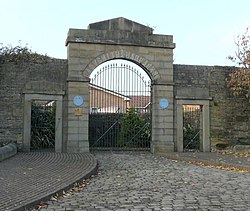
Stamford Park, Tameside
Stamford Park is a park in Stalybridge, Tameside, Greater Manchester. The park was Grade II listed with Historic England in 1986.

Ashton Park Parade railway station
Ashton Park Parade was a station on the line between Guide Bridge and Stalybridge in Greater Manchester. This station served the town of Ashton-under-Lyne, now served only by Ashton Charlestown, north of this former station.

Minerva Mill, Ashton-under-Lyne
Minerva Mill was a cotton spinning mill in Ashton-under-Lyne, Greater Manchester. It was built between 1891 and 1892 for the Minerva Spinning Company. It ceased spinning cotton in the 1920s and was demolished in 1937.

Texas Mill, Ashton-under-Lyne
Texas Mill was a cotton spinning mill in the Whitelands district of Ashton-under-Lyne, Greater Manchester. It was built between 1905 and 1907 for the Ashton Syndicate by Sydney Stott of Oldham. The mill was destroyed in a massive fire on 22–23 October 1971.
Ladysmith Barracks
Ladysmith Barracks was a British military installation on Mossley Road, Ashton-under-Lyne, Greater Manchester. It is located in the area of Manchester.

Old Street drill hall, Ashton-under-Lyne
Old Street drill hall is a former military installation in Ashton-under-Lyne, Greater Manchester, England. The Old Street Drill Hall is located on the Old Street Road, Old Street.

Cavendish Mill, Ashton-under-Lyne
Cavendish Mill was built between 1884 and 1885 for the Cavendish Spinning Company by Potts, Pickup & Dixon of Oldham. It ceased spinning cotton in 1934 and was then used for a variety of purposes before it was converted into housing in 1994.

Dukinfield (ward)
Dukinfield is an electoral ward of Tameside, England. It is represented in Westminster by Andrew Gwynne Labour MP for Denton and Reddish.
Visit Stalybridge plaques
 59
59
plaques
here Stalybridge has 59 physical plaques in tourist plaque schemes for you to explore via Walkfo Stalybridge plaques audio map when visiting. Plaques like National Heritage’s “Blue Plaques” provide visual geo-markers to highlight points-of-interest at the places where they happened – and Walkfo’s AI has researched additional, deeper content when you visit Stalybridge using the app. Experience the history of a location when Walkfo local tourist guide app triggers audio close to each Stalybridge plaque. Explore Plaques & History has a complete list of Hartlepool’s plaques & Hartlepool history plaque map.


 Trying to encourage visitors to Stalybridge?