Welcome to Visit Sholver Places
The Walkfo guide to things to do & explore in Sholver
 Visit Sholver places using Walkfo for free guided tours of the best Sholver places to visit. A unique way to experience Sholver’s places, Walkfo allows you to explore Sholver as you would a museum or art gallery with audio guides.
Visiting Sholver Walkfo Preview
Sholver is an elevated, residential area of Oldham, in Greater Manchester. It lies near the middle of the Oldham part of the valley of the River Beal. Historically a part of Lancashire, Sholver and its surroundings have provided archaeological evidence of Neolithic activity. When you visit Sholver, Walkfo brings Sholver places to life as you travel by foot, bike, bus or car with a mobile phone & headphones.
Sholver Places Overview: History, Culture & Facts about Sholver
Visit Sholver – Walkfo’s stats for the places to visit
With 61 audio plaques & Sholver places for you to explore in the Sholver area, Walkfo is the world’s largest heritage & history digital plaque provider. The AI continually learns & refines facts about the best Sholver places to visit from travel & tourism authorities (like Wikipedia), converting history into an interactive audio experience.
Sholver history
Early evidence of human presence in what is now Sholver and adjacent Moorside is attested by the discovery of Neolithic flint arrow-heads and workings found at Besom Hill, implying habitation 7–10,000 years ago. Norsemen occupied Sholver in the 10th century, where they erected shielings – temporary huts in a remote pasture.
Sholver geography / climate

Sholver stands on a steep hillside, about 1,000 feet (304.8 m) above sea level, 2.1 miles (3.4 km) northeast of Oldham’s commercial centre. Saddleworth and the South Pennines are close to the east.
Why visit Sholver with Walkfo Travel Guide App?
 You can visit Sholver places with Walkfo Sholver to hear history at Sholver’s places whilst walking around using the free digital tour app. Walkfo Sholver has 61 places to visit in our interactive Sholver map, with amazing history, culture & travel facts you can explore the same way you would at a museum or art gallery with information audio headset. With Walkfo, you can travel by foot, bike or bus throughout Sholver, being in the moment, without digital distraction or limits to a specific walking route. Our historic audio walks, National Trust interactive audio experiences, digital tour guides for English Heritage locations are available at Sholver places, with a AI tour guide to help you get the best from a visit to Sholver & the surrounding areas.
“Curated content for millions of locations across the UK, with 61 audio facts unique to Sholver places in an interactive Sholver map you can explore.”
Walkfo: Visit Sholver Places Map
61 tourist, history, culture & geography spots
Sholver historic spots | Sholver tourist destinations | Sholver plaques | Sholver geographic features |
| Walkfo Sholver tourism map key: places to see & visit like National Trust sites, Blue Plaques, English Heritage locations & top tourist destinations in Sholver | |||
Best Sholver places to visit
Sholver has places to explore by foot, bike or bus. Below are a selection of the varied Sholver’s destinations you can visit with additional content available at the Walkfo Sholver’s information audio spots:

Crompton Hall
Crompton Hall was an historic house situated at Crompton Fold in the township of Crompton, Lancashire, and within the historic parish of Prestwich-cum-Oldham .

Orme Mill, Waterhead
Orme Mill, Waterhead is a cotton spinning mill in Waterhead, Oldham, Greater Manchester. It was built in 1908 and was taken over by Lancashire Cotton Corporation in the 1930s. Production finished in 1960 and the mill was passed on to Ferranti in 1964.
St James’ Church, Oldham
St James’ Church is in Barry Street, Greenacres Moor, Oldham, Greater Manchester. It is an active Anglican parish church in the deanery of Oldham East, the archdeaconry of Rochdale, and the diocese of Manchester. The church is recorded in the National Heritage List for England as a designated Grade II listed building.
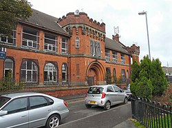
Rifle Street drill hall, Oldham
Rifle Street drill hall is a former military installation in Oldham, Oldham. It is a drill hall used to be used as a military drill hall for training purposes.
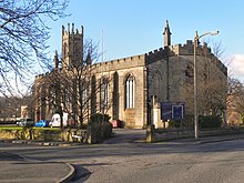
Oldham Parish Church
The Church of St. Mary with St. Peter, mostly known as Oldham Parish Church, is the Church of England parish church for Oldham in Greater Manchester. It forms part of the Diocese of Manchester, and is one of several Grade II* listed buildings. A church building had existed on the site since 1280 and was replaced by an Early English Gothic Church in the 15th century.

Oldham War Memorial
Oldham War Memorial is a large bronze sculpture group on a granite plinth. It was built to commemorate the men of Oldham who were killed in the First World War. Bronze plaques on the wall of the churchyard nearby list the fallen, including Mabel Drinkwater, a nurse who died after an operation at Oldham Royal Infirmary. The memorial became a Grade II listed building in 1973 and was upgraded to Grade II* in December 2016.

Greenhill power station
Greenhill power station was built over the period 1921–24 and was decommissioned in 1960. It replaced the older Rhodes Bank generating station and was superseded by Chadderton B power station.

Old Town Hall, Oldham
The Old Town Hall is a municipal building in Yorkshire Street, Oldham, England. It is a Grade II listed building. It was built in the 1960s.
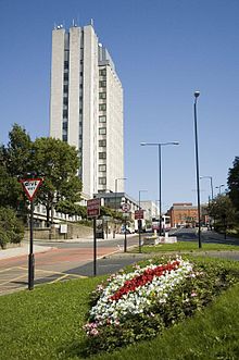
Oldham Civic Centre
Oldham Civic Centre is a municipal building in West Street, Oldham, England. It is located in the centre of Oldham’s West Street.

St Thomas’ Church, Friarmere
St Thomas’ Church, Friarmere, also known as Heights Chapel, is a redundant Anglican church on a hillside overlooking the village of Delph, Greater Manchester. It is recorded in the National Heritage List for England as a designated Grade II* listed building.
Visit Sholver plaques
 4
4
plaques
here Sholver has 4 physical plaques in tourist plaque schemes for you to explore via Walkfo Sholver plaques audio map when visiting. Plaques like National Heritage’s “Blue Plaques” provide visual geo-markers to highlight points-of-interest at the places where they happened – and Walkfo’s AI has researched additional, deeper content when you visit Sholver using the app. Experience the history of a location when Walkfo local tourist guide app triggers audio close to each Sholver plaque. Explore Plaques & History has a complete list of Hartlepool’s plaques & Hartlepool history plaque map.


 Trying to encourage visitors to Sholver?