Welcome to Visit Limpsfield Places
The Walkfo guide to things to do & explore in Limpsfield
 Visit Limpsfield places using Walkfo for free guided tours of the best Limpsfield places to visit. A unique way to experience Limpsfield’s places, Walkfo allows you to explore Limpsfield as you would a museum or art gallery with audio guides.
Visiting Limpsfield Walkfo Preview
Limpsfield is a village and civil parish in Surrey. It is at the foot of the North Downs close to Oxted railway station and the A25. The composer Frederick Delius and orchestral conductor Sir Thomas Beecham are buried in the village churchyard. There are 89 listed buildings. When you visit Limpsfield, Walkfo brings Limpsfield places to life as you travel by foot, bike, bus or car with a mobile phone & headphones.
Limpsfield Places Overview: History, Culture & Facts about Limpsfield
Visit Limpsfield – Walkfo’s stats for the places to visit
With 14 audio plaques & Limpsfield places for you to explore in the Limpsfield area, Walkfo is the world’s largest heritage & history digital plaque provider. The AI continually learns & refines facts about the best Limpsfield places to visit from travel & tourism authorities (like Wikipedia), converting history into an interactive audio experience.
Limpsfield history

Limpsfield appears in the Domesday Book of 1086 as Limenesfeld. It was held by the Abbot of Battle Abbey, Sussex. The parish church of Saint Peter was constructed in the late 12th century and is grade I listed building.
Limpsfield landmarks
Limpsfield Chart has a golf course and cricket club. The village heart is in a conservation area and some of the surrounding area is National Trust land. Staffhurst Wood is also within the parish and is notable for its bluebells in spring.
Limpsfield geography / climate
The built up section is north of Hurst Green and both east and north-east of Oxted. The lowest elevation is 62m at Staffhurst Wood on the south-western parish boundary on the River Eden, Kent. The M25 motorway is to the north and Junction 6 for Godstone is 3+1/2 miles west.
Why visit Limpsfield with Walkfo Travel Guide App?
 You can visit Limpsfield places with Walkfo Limpsfield to hear history at Limpsfield’s places whilst walking around using the free digital tour app. Walkfo Limpsfield has 14 places to visit in our interactive Limpsfield map, with amazing history, culture & travel facts you can explore the same way you would at a museum or art gallery with information audio headset. With Walkfo, you can travel by foot, bike or bus throughout Limpsfield, being in the moment, without digital distraction or limits to a specific walking route. Our historic audio walks, National Trust interactive audio experiences, digital tour guides for English Heritage locations are available at Limpsfield places, with a AI tour guide to help you get the best from a visit to Limpsfield & the surrounding areas.
“Curated content for millions of locations across the UK, with 14 audio facts unique to Limpsfield places in an interactive Limpsfield map you can explore.”
Walkfo: Visit Limpsfield Places Map
14 tourist, history, culture & geography spots
Limpsfield historic spots | Limpsfield tourist destinations | Limpsfield plaques | Limpsfield geographic features |
| Walkfo Limpsfield tourism map key: places to see & visit like National Trust sites, Blue Plaques, English Heritage locations & top tourist destinations in Limpsfield | |||
Best Limpsfield places to visit
Limpsfield has places to explore by foot, bike or bus. Below are a selection of the varied Limpsfield’s destinations you can visit with additional content available at the Walkfo Limpsfield’s information audio spots:

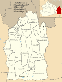
Tandridge District
Tandridge is a local government district in east Surrey. Its council is based in Oxted, although the largest settlement is Caterham. In mid-2019, the district had an estimated population of 88,129.
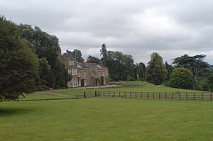
Titsey Place
Titsey Place was built by Sir John Gresham (1495–1556) on the site of a earlier dwelling. The mostly Tudor house was demolished and rebuilt in the 18th century, before being refronted in 1826. Finally a tower was added in 1856.

Tatsfield Receiving Station
The Tatsfield Receiving Station was a radio broadcasting signals-receiving and frequency-measuring facility operated by the British Broadcasting Corporation. The station was in operation between 1929 and 1974.
Visit Limpsfield plaques
 2
2
plaques
here Limpsfield has 2 physical plaques in tourist plaque schemes for you to explore via Walkfo Limpsfield plaques audio map when visiting. Plaques like National Heritage’s “Blue Plaques” provide visual geo-markers to highlight points-of-interest at the places where they happened – and Walkfo’s AI has researched additional, deeper content when you visit Limpsfield using the app. Experience the history of a location when Walkfo local tourist guide app triggers audio close to each Limpsfield plaque. Explore Plaques & History has a complete list of Hartlepool’s plaques & Hartlepool history plaque map.


 Trying to encourage visitors to Limpsfield?