Welcome to Visit Lichfield Places
The Walkfo guide to things to do & explore in Lichfield
 Visit Lichfield places using Walkfo for free guided tours of the best Lichfield places to visit. A unique way to experience Lichfield’s places, Walkfo allows you to explore Lichfield as you would a museum or art gallery with audio guides.
Visiting Lichfield Walkfo Preview
Lichfield is a cathedral city and civil parish in Staffordshire. It was the birthplace of Samuel Johnson, the writer of the first authoritative Dictionary of the English Language. At the time of the 2011 Census the population was estimated at 32,219 and the wider Lichfield District at 100,700. The centre of the city has over 230 listed buildings and preserves much of its historic character. When you visit Lichfield, Walkfo brings Lichfield places to life as you travel by foot, bike, bus or car with a mobile phone & headphones.
Lichfield Places Overview: History, Culture & Facts about Lichfield
Visit Lichfield – Walkfo’s stats for the places to visit
With 42 audio plaques & Lichfield places for you to explore in the Lichfield area, Walkfo is the world’s largest heritage & history digital plaque provider. The AI continually learns & refines facts about the best Lichfield places to visit from travel & tourism authorities (like Wikipedia), converting history into an interactive audio experience.
Lichfield history
Prehistory and antiquity
The earliest evidence of settlement is Mesolithic flints discovered on the high ground of the cemetery at St Michael on Greenhill, which may indicate an early flint industry. 2.2 mi (3.5 km) south-west of Lichfield, near the point where Icknield Street crosses Watling Street, was the site of Letocetum (the Brittonic *Lētocaiton, “Greywood”) Established in AD 50 as a Roman military fortress, it had become a civilian settlement (vicus) with a bath house and a mansio.
Middle Ages

Lichfield was the episcopal see of the Mercians in 669. The first Christian king of Mercia, Wulfhere, donated land at Lichfield for St Chad to build a monastery. In 786 King Offa made Lichfield an archbishopric with authority over all bishops from the Humber to the River Thames. First cathedral was built on the present site in 700 when Bishop Hædde built a new church to house the bones of St Chad, which had become the centre of a sacred shrine to pilgrims.
Early Modern

Last public burning at the stake in England took place in Lichfield in 1612 for promoting himself as the divine Paraclete and Saviour of the world. The Reformation brought the disappearance of pilgrim traffic following the destruction of St Chad’s shrine in 1538. Further economic decline followed the outbreak of plague in 1593, which resulted in the death of over a third of the entire population.
Late Modern and contemporary
Lichfield remained largely unchanged in character during the Industrial Revolution. First council houses were built in the Dimbles area of the city in the 1930s. The outbreak of World War II brought over 2,000 evacuees from industrialised areas. The city’s population tripled between 1951 and the late 1980s.
Lichfield etymology
At Wall, 3.5 km (2.2 mi) south of the current city, there was a Romano-British village, Letocetum, a Common Brittonic place name meaning “Greywood” Popular etymology has it that a thousand Christians were martyred in Lichfield around AD 300 during the reign of Diocletian.
Lichfield geography / climate
Lichfield covers an area of approximately 5.41 sq mi (14.0 km) in the south-east of Staffordshire in the West Midlands region of England. The city is located between Cannock Chase and the valleys of the Rivers Trent and Tame to the east. It is underlain by red sandstone, deposited during the arid desert conditions of the Triassic period.
Why visit Lichfield with Walkfo Travel Guide App?
 You can visit Lichfield places with Walkfo Lichfield to hear history at Lichfield’s places whilst walking around using the free digital tour app. Walkfo Lichfield has 42 places to visit in our interactive Lichfield map, with amazing history, culture & travel facts you can explore the same way you would at a museum or art gallery with information audio headset. With Walkfo, you can travel by foot, bike or bus throughout Lichfield, being in the moment, without digital distraction or limits to a specific walking route. Our historic audio walks, National Trust interactive audio experiences, digital tour guides for English Heritage locations are available at Lichfield places, with a AI tour guide to help you get the best from a visit to Lichfield & the surrounding areas.
“Curated content for millions of locations across the UK, with 42 audio facts unique to Lichfield places in an interactive Lichfield map you can explore.”
Walkfo: Visit Lichfield Places Map
42 tourist, history, culture & geography spots
Lichfield historic spots | Lichfield tourist destinations | Lichfield plaques | Lichfield geographic features |
| Walkfo Lichfield tourism map key: places to see & visit like National Trust sites, Blue Plaques, English Heritage locations & top tourist destinations in Lichfield | |||
Best Lichfield places to visit
Lichfield has places to explore by foot, bike or bus. Below are a selection of the varied Lichfield’s destinations you can visit with additional content available at the Walkfo Lichfield’s information audio spots:

Curborough and Elmhurst
Curborough and Elmhurst is a civil parish in Lichfield District, Staffordshire. The name of Curborough means ‘cweorn burna’ and likely referred to Curborough brook. The parish council is a joint one with Farewell and Chorley.

Bishop’s Palace, Lichfield
The Bishop’s Palace is a 17th-century building situated in the north east corner of the Cathedral Close in Lichfield, Staffordshire. The first palace was destroyed during the English Civil War and rebuilt in 1687. The palace was residence to the Bishop of Lichfield from the late 1860s until 1954, it is now used by Lichfield Cathedral School.
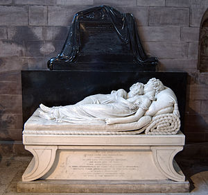
The Sleeping Children
The Sleeping Children is a marble sculpture by Francis Chantrey. It depicts Ellen-Jane and Marianne Robinson asleep in each other’s arms on a bed. The statue was placed in the south east corner of Lichfield Cathedral in 1817. The work is considered to be one of the greatest works of English sculpture during the period.

Siege of Lichfield
The Siege of Lichfield occurred on 8–21 April 1643 during the First English Civil War. Royalists under the command of Prince Rupert successfully besieged the Parliamentary garrison.

Cathedral Close, Lichfield
The Cathedral Close is a historic set of buildings surrounding Lichfield Cathedral in Lichfield. The Close comprises buildings associated with the cathedral and the clergy which encircle the Cathedral. The majority of buildings date from the 17th, 18th and 19th centuries.

Guildhall, Lichfield
The Guildhall is a Grade II listed building in Lichfield, Staffordshire. The guildhall is located in Bore Street, Lichfield in the United Kingdom.
![]()
Lichfield City F.C.
Lichfield City Football Club is a football club based in Lichfield, Staffordshire. They are members of the Midland League Premier Division and play at the City Ground.

St Michael on Greenhill, Lichfield
St Michael on Greenhill is a parish church in Lichfield, Staffordshire. It is located on the high ground of Greenhill in the east of the city. A church has been on the present site since at least 1190 but the current building dates mainly from the restoration of 1842–43. The churchyard is one of five ancient burial grounds in England.

Lichfield District
Lichfield (UK: /ˈlɪtʃˌfiːld) is a local government district in Staffordshire. It is administered by Lichfield District Council, based in Lichfield. The district was formed on 1 April 1974, under the Local Government Act 1972, by a merger of the existing City of Lichfield with most of the Lichfield Rural District.

Hospital of St John Baptist without the Barrs
The Hospital of St John Baptist without the Barrs is a Grade I listed building in Lichfield, Staffordshire. It once provided accommodation to travellers outside the southern city walls. The distinctive eight chimneys fronting St John’s Street date back to the Tudor period when the hospital served as an almshouse for elderly gentlemen.
Visit Lichfield plaques
 29
29
plaques
here Lichfield has 29 physical plaques in tourist plaque schemes for you to explore via Walkfo Lichfield plaques audio map when visiting. Plaques like National Heritage’s “Blue Plaques” provide visual geo-markers to highlight points-of-interest at the places where they happened – and Walkfo’s AI has researched additional, deeper content when you visit Lichfield using the app. Experience the history of a location when Walkfo local tourist guide app triggers audio close to each Lichfield plaque. Explore Plaques & History has a complete list of Hartlepool’s plaques & Hartlepool history plaque map.


 Trying to encourage visitors to Lichfield?