Welcome to Visit Kersal Places The Walkfo guide to things to do & explore in Kersal
Visit Kersal places using Walkfo for free guided tours of the best Kersal places to visit. A unique way to experience Kersal’s places, Walkfo allows you to explore Kersal as you would a museum or art gallery with audio guides.
Visiting Kersal Walkfo Preview Kersal has the second oldest building in Salford, Kersal Cell, which was built in 1563. Kersal Dale Country Park has been designated as a Local Nature Reserve and Kersal Moor as a Site of Biological Importance. When you visit Kersal, Walkfo brings Kersal places to life as you travel by foot, bike, bus or car with a mobile phone & headphones.
Kersal Places Overview: History, Culture & Facts about Kersal
Visit Kersal – Walkfo’s stats for the places to visit
With 220 audio plaques & Kersal places for you to explore in the Kersal area, Walkfo is the world’s largest heritage & history digital plaque provider. The AI continually learns & refines facts about the best Kersal places to visit from travel & tourism authorities (like Wikipedia), converting history into an interactive audio experience.
Kersal history
Kersal has been variously known as Kereshale, Kershal, Kereshole, Carshall and Kersall. The name incorporates the Old English word halh, meaning “a piece of flat alluvial land by the side of a river”. “Kersal” indicates that this was land where cress grew. In 1142, Kereshale was given to the Priory of Lenton, an order of Cluniac monks, who established an early cell there named St Leonard’s. On the Dissolution of the Monasteries in 1540 Henry VIII sold the priory and its lands to one Baldwin Willoughby. It was sold eight years later to Ralph Kenyon, who was acting on behalf of himself, James Chetham of Crumpsall and Richard Siddall of Withington. The Kenyon third was sold about the year 1660 to the Byroms of Manchester, whose line terminated on the death of Eleanora Atherton in 1870. All the land eventually descended to, or was bought by, the Clowes family (the Lords of the Manor of Broughton) who began to sell off the land for development in the 19th and early 20th centuries. The most famous resident of Kersal Cell was John Byrom (1692–1763). It is said that he wrote the hymn Christians Awake there, but it is more likely that it was written at his home in the Old Shambles in Manchester above what is now the Wellington Inn. In the 17th century, the Kersal Moor races were the great event of the year. They usually took place around Whit Week when large numbers of people turned the area into a giant fairground for several days. The moor was also used for nude male races, allowing females to study the form before choosing their mates. Indeed, in the 18th century, Roger Aytoun, known as “Spanking Roger”, later a hero of the Siege of Gibraltar, acquired Hough Hall in Moston, through marriage after such a race. Kersal Moor was also host to one of the great political events of the 19th century, when it was the meeting place for the largest of the Chartist Assemblies attended by at least 30,000 people in September 1838 and again in May 1839. It was also the site of one of the first golf courses to be built outside Scotland. Kersal Links opened in 1818, and was the oldest golf course between the Thames and the Tweed until it closed in 1960. The Kersal Moor races began prior to 1680 and continued, with various interruptions, until 1847 when the course was switched to the other side of the River Irwell, to Castle Irwell, where it remained until 1963. In 1961 the Members’ Stand at the Castle Irwell Racecourse was opened and contained the world’s first executive boxes. The architect for the racecourse, Ernest Atherden, showed this to the directors of Manchester United who opened their first executive box in 1965, and hence began the modern corporatisation of sport. Kersal remained a rural area until about 1840 when the Clowes family, who owned most of the land in the area, began to sell it off for development, and merchants and manufacturers began to build their mansions in the green fields of Higher Broughton and Kersal. In keeping with their own ideas of social engineering they imposed strict covenants on how the land was used, reserving the higher ground for more well-to-do residents and the lower ground for workers’ cottages. The number of public houses was severely restricted and then, only beer houses that didn’t sell spirits were allowed. Singleton Road and Moor Lane were the only roads connecting Bury Old Road and Bolton Road and there was a toll bar on the corner of Bury Old Road. When Bury New Road was built in 1831 a gate or bar was erected and travellers had to pay a toll to the turnpike trust to pass through. A toll house was erected on Bury New Road with a bay window projecting out so that the toll collector had a clear view of the road. By 1848 the local authority had taken over the road, the tolls were abolished and the toll collector’s house became a newsagent’s. This was the only shop in an area where the landowner’s restrictive covenants prevented commercial development. The exterior of the house remains largely unchanged to this day, although it was renovated in 2007 with a two-storey extension being added to the rear. The Toll House is now a Grade II listed building. In the 1930s a large council housing estate was built to the east of Littleton Road. Twelve high-rise tower blocks, known as Kersal flats, were constructed for Salford Council in the 1960s. Eight of these were demolished in 1990. The other blocks were sold to private developers to renovate for private sale. The Housing Act 1980 gave tenants the right to buy. Since then much of the council estate has been sold to sitting tenants and by 2011 just over 50% of homes in the Kersal Ward were in owner-occupation.
Kersal geography / climate
Kersal is bounded on the north by Singleton Brook, which defines the border with Prestwich, on the south and west by the River Irwell and on the east by Broughton. The west and south of the district lie in the flood-plain of the river, and consequently have historically been subject to flooding. Serious floods were documented in 1866, 1946, 1954 and 1980.
Why visit Kersal with Walkfo Travel Guide App?
You can visit Kersal places with Walkfo Kersal to hear history at Kersal’s places whilst walking around using the free digital tour app. Walkfo Kersal has 220 places to visit in our interactive Kersal map, with amazing history, culture & travel facts you can explore the same way you would at a museum or art gallery with information audio headset. With Walkfo, you can travel by foot, bike or bus throughout Kersal, being in the moment, without digital distraction or limits to a specific walking route. Our historic audio walks, National Trust interactive audio experiences, digital tour guides for English Heritage locations are available at Kersal places, with a AI tour guide to help you get the best from a visit to Kersal & the surrounding areas.
“Curated content for millions of locations across the UK, with 220 audio facts unique to Kersal places in an interactive Kersal map you can explore.”
Walkfo Kersal tourism map key: places to see & visit like National Trust sites, Blue Plaques, English Heritage locations & top tourist destinations in Kersal
Best Kersal places to visit
Kersal has places to explore by foot, bike or bus. Below are a selection of the varied Kersal’s destinations you can visit with additional content available at the Walkfo Kersal’s information audio spots:
Blackley Cemetery Blackley Cemetery is a large, municipal cemetery situated within the northern suburbs of Manchester . It is owned, operated and maintained by Manchester City Council . It was opened in 1953 on land that was previously a golf course .
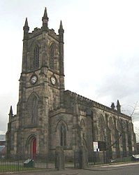
Church of the Ascension, Lower Broughton The Church of the Ascension is a Grade II listed Anglican church in Lower Broughton, Salford, England. In February 2017 a fire destroyed the roof and interior of the building.
HM Prison Manchester HM Prison Manchester is a high-security men’s prison in Manchester, England, operated by Her Majesty’s Prison Service. It is known for its prominent ventilation tower and imposing design. It was designed by Alfred Waterhouse and opened in 1868 alongside the demolished Manchester Assize Courts.
Pendlebury (ward) Pendlebury is an electoral ward of Salford, England. It is represented in Westminster by Rebecca Long-Bailey MP Rebecca Long Bailey. A profile of the ward conducted in 2014 recorded a population of 13,434.
Irwell Riverside (ward) Irwell Riverside (ward) is an electoral ward of Salford, England. The ward is bounded by meanders of the River Irwell and includes the main university campus. It is represented in Westminster by Rebecca Long-Bailey MP for Salfords and Eccles.
St Thomas’ Church, Pendleton St Thomas’ Church is on Broad Street, Pendleton, Salford, Greater Manchester. It was a Commissioners’ church, having received a grant towards its construction from the Church Building Commission. It is designated by English Heritage as a Grade II listed building.
Greater Manchester Built-up Area The Greater Manchester Built-up Area has a population of 2,553,379 according to the United Kingdom Census 2011. It is the second most populous conurbation in the UK after the Greater London built-up area. The area is not conterminous with Greater Manchester, for it excludes settlements such as Wigan and Marple from Greater Manchester.
HM Prison Forest Bank HM Prison Forest Bank is a Category B men’s private prison. It is located in the Agecroft area of Pendlebury in Salford near Manchester. The prison is operated by Sodexo Justice Services.
Irlams o’ th’ Height Irlams o’ th’ Height is a suburb of Salford, Greater Manchester, England. It is located in the centre of the city’s population.
Salford Acoustics Salford Acoustics is based in two locations: (i) 3 km west of Manchester city centre, UK, and (ii) on the banks of the Manchester Ship Canal at MediaCityUK. It undertakes public and industrial research in acoustics and carries out commercial testing.
Visit Kersal plaques
98 plaques hereKersal has 98 physical plaques in tourist plaque schemes for you to explore via Walkfo Kersal plaques audio map when visiting. Plaques like National Heritage’s “Blue Plaques” provide visual geo-markers to highlight points-of-interest at the places where they happened – and Walkfo’s AI has researched additional, deeper content when you visit Kersal using the app. Experience the history of a location when Walkfo local tourist guide app triggers audio close to each Kersal plaque. Explore Plaques & History has a complete list of Hartlepool’s plaques & Hartlepool history plaque map.
Experience Kersal audio walks & tours
Walkfo guides for things to do / places to visit in Kersal allows exploration as you would do an art gallery or museum. Walk close to one of Kersal’s 220 historic places & our digital tour guide will create an audio story for that spot. With headphone connected, you can explore Kersal freely by foot, bike or bus – with your own personal tour guide in your pocket.
Explore Kersal Map App
Our visit Kersal map shows you things-to-do & places you can visit in Kersal & surrounding areas using the Walkfo digital audio tour guide app. Each spot has plaque, building, street or area information on history, culture or tourism.
You can set your Walkfo’s Kersal tourist map to find historic & tourism spots within 1km, 3km & 5km of the Kersal centre, depending on how far you plan to explore whilst you visit Kersal area at LONG:-2.278237, LAT:53.510062.
Walkfo App
Walkfo
Walkfo is free to download & use (for a limited time period), so if you are looking to explore Kersal, go to your App Store to search for “Walkfo” or follow a links below and install on your mobile phone. Walkfo is designed for use with headphones or AirPods, so you can walk & explore whilst learning about the things around you without digital distraction.
Things to do & visit in Kersal / surrounding areas
● Salford Royal NHS Foundation Trust ● Swinton South (ward) ● Salford Royal Hospital ● Blackley ● North Manchester General Hospital ● Crumpsall Park ● Smedley, Manchester ● Abraham Moss tram stop ● Crumpsall tram stop ● Crumpsall ● St Luke’s Church, Manchester ● Museum of Transport, Greater Manchester ● North Manchester Jamia Mosque ● St Mary’s Ukrainian Catholic Church, Manchester ● Church of St John the Evangelist, Cheetham Hill ● Irk Valley Junction rail crash ● Heaton Park Hebrew Congregation ● Blackley Cemetery ● Manchester Fort ● Sandhills tram stop ● Bowker Vale tram stop ● St James’ Church, Broughton ● Manchester Jewish Museum ● Glenbrook, Greater Manchester ● Great Heaton ● Havelock Mills ● Heaton Park Tramway ● St Chad’s, Cheetham Hill ● Greek Orthodox Church of the Annunciation, Manchester ● Strangeways, Manchester
● Heaton Park tram stop ● Heaton Park ● Heaton Park Congregational Church ● Salford City F.C. ● The Cliff (training ground) ● Heaton Park BT Tower ● Prestwich Cricket, Tennis & Bowling Club ● St Margaret’s Church, Prestwich ● Broughton, Salford ● Heaton Park Reservoir ● Prestwich tram stop ● Prestwich ● Church of the Ascension, Lower Broughton ● Wheater’s Field ● HM Prison Manchester ● Prestwich Heys A.F.C. ● Besses o’ th’ Barn ● Besses o’ th’ Barn tram stop ● Prestwich Hospital ● Park Lane (stadium) ● Swinton Lions ● Philips Park, Prestwich ● Clifton Viaduct ● Clifton Aqueduct ● Fletcher’s Canal ● Barton upon Irwell Rural District ● Clifton, Greater Manchester ● Drinkwater Park ● Pendlebury (ward) ● Agecroft Power Station ● The Tree of Knowledge (mural) ● Irwell Riverside (ward) ● Agecroft Colliery ● Agecroft Cemetery ● Manchester Bolton & Bury Canal ● Wat Phra Dhammakaya Manchester ● Pendleton, Greater Manchester ● St Thomas’ Church, Pendleton ● Greater Manchester Built-up Area ● Seedley ● County Borough of Salford ● Salford Shopping Centre ● HM Prison Forest Bank ● Agecroft ● Victoria Theatre, Salford ● Irlams o’ th’ Height ● Salford Acoustics ● Langworthy (ward) ● Peel Building ● Salford Museum and Art Gallery ● Centenary Building ● University of Salford ● Working Class Movement Library ● Manchester Assize Courts ● Langworthy, Salford ● Pendlebury ● St Philip’s Church, Salford ● Claremont (ward) ● Asian Sound ● Buile Hill Park ● Salford Cathedral ● Blackfriars, Greater Manchester ● Manchester City Region ● 100 Greengate ● Weaste ● Salford Town Hall ● Cross Lane drill hall, Salford ● Manchester Tennis and Racquet Club ● Pendlebury Children’s Hospital ● Islington Mill ● Threlfalls Brewery ● Strangeways Brewery ● Windsor Link Line, Salford ● Municipal Borough of Swinton and Pendlebury ● Greengate, Salford ● St Luke’s Church, Pendleton ● Manchester Arena ● River Irk ● The Willows, Salford ● Peninsula Building ● Manchester Arena bombing ● Langworthy tram stop ● Science and Industry Museum ● St John’s Gardens, Manchester ● St John’s Church, Manchester ● The Factory (Manchester) ● River Irwell Railway Bridge ● Skytrak ● Granada Studios Tour ● Ordsall Chord ● County Court, Manchester ● Sunlight House ● Granada Studios ● 1 Spinningfields ● St John’s, Manchester ● Manchester Opera House ● Manchester Victoria Reversing Sidings ● Green Quarter ● Greater Manchester County Record Office ● One Angel Square ● NOMA (Manchester) ● Angel of the Meadow ● Smithfield Market Hall ● New Century House ● Redfern Building ● CIS Tower ● Sadler’s Yard ● Holyoake House ● Hanover Building ● Manchester Castle ● Centre for Chinese Contemporary Art ● Shudehill Interchange ● Statue of Michael Jackson ● National Football Museum ● Harry Langton Collection ● Ye Olde Rovers Return ● Cathedral Gardens ● Palatine Bridge, Salford ● Corn Exchange, Manchester ● Exchange Square, Manchester ● Wheel of Manchester ● The Old Wellington Inn ● Exchange Square tram stop ● Shambles Square, Manchester ● Manchester Arndale ● Victoria Arches ● Victoria Bridge, Manchester ● North Tower (Salford) ● No. 1 Deansgate ● Manchester Stock Exchange ● Royal Exchange, Manchester ● Blackfriars Bridge, Manchester ● Manchester International Festival ● Barton Arcade ● The Moon Under Water, Manchester ● The Circle Club ● Weaste tram stop ● Weaste and Seedley (ward) ● Ordsall (ward) ● Salford Lads’ Club ● Roman Catholic Diocese of Salford ● Mersey and Irwell Navigation ● Manchester Hydraulic Power ● People’s History Museum ● Spinningfields ● Albert Bridge, Manchester ● Heart North West ● Capital Manchester ● Smooth North West ● Capital Manchester and Lancashire ● XS Manchester ● Swinton Square ● City of Salford ● Victoria Park, Swinton ● Pendlebury Colliery ● Clifton Hall Tunnel ● St Augustine’s Church, Pendlebury ● Manchester Civil Justice Centre ● 1 The Avenue ● Trinity Bridge, Greater Manchester ● Manchester Library & Information Service ● Lowry Hotel ● John Rylands Library ● Lincoln House, Manchester ● Arkwright House, Manchester ● Kendals ● St Ann’s Church, Manchester ● The Hidden Gem ● 1984 Eccles rail crash ● Cheetham, Manchester ● Kersal Moor ● Kersal ● Church of St Mary the Virgin, Prestwich ● Broughton Suspension Bridge ● Pilkington’s Lancastrian Pottery & Tiles ● Clifton Hall Colliery ● Pendleton Colliery ● Peel Park, Salford ● Greater Manchester ● Salford ● St Michael’s Flags and Angel Meadow Park ● Shudehill Mill ● Chetham’s Library ● The Printworks (Manchester) ● Manchester Cathedral ● Hanging Bridge ● Moor Lane ● Cheetham Hill
Getting to / around Kersal – transport link, station & street map
Getting around in Kersal using public transportation may include road, street, train, underground, bus or tram transport options. Walkfo has identified the following Kersal places with historic / cultural / factual content when you visit:
Local Kersal Public Transport Stations
Kersal Notable Streets & Road Destinations
Molyneux Brow railway station
Clifton railway station (Greater Manchester)
Pendleton Bridge railway station
Pendleton railway station
Agecroft Bridge railway station
Irlams o’ th’ Height railway station
Salford Crescent railway station
Oldfield Road railway station
Cross Lane railway station
Salford Central railway station
Pendlebury railway station
Manchester Exchange railway station
Seedley railway station
Manchester Liverpool Road railway station
1830 warehouse, Liverpool Road railway station
Ordsall Lane railway station
Manchester Victoria station
Weaste railway station
Swinton railway station (Greater Manchester)
Woodlands Road tram stop
Queens Road tram stop
Cheetham Hill Road
Coronation Street sets
Quay Street
High Street tram stop
Corporation Street Bridge
Market Street, Manchester
New Cathedral Street
Cross Street Chapel
25 St Ann Street
Station Road, Swinton
3 Hardman Street
King Street, Manchester
53 King Street
[transportsummary]
Local Kersal historians & Kersal tour guides
Trying to encourage visitors to Kersal? Walkfo has millions audio places already available but Walkfo Creator gives Kersal’s places, attractions & landmarks ability to create their own unique outdoor audio museums & using our simple & easy to use Walkfo Creator. – Creating a new audio experience for your Kersal place is free* and quick (15+ minutes if you prepare text content) to use, with Walkfo Creator doing the hard work of generating AI audio files for geo-spots from the text you provide with a simply click on a map. – The 100 Amazing Kersal Places is just one example of an outdoor museum created using Walkfo Creator (pictured to the left) for people to safely explore during Covid-19 times whilst visiting a city. Our tool is open to tourism organisations, travel destinations & National Trust locations to create their own audio walks to offer free when people visit Kersal destinations. – Walkfo itself is looking to partner with websites offering things-to-do / what’s on events listings to enhance the content of our ‘visit-Kersal’ web pages (for example: www.visitKersal.com). If you are interested in partnering, please contact us to discuss options.
* Walkfo Creator is free to use for a limited number of audio spots within a map with a license fee applicable when more than 20 audio spots within location walk are created. v1.1336
 Visit Kersal places using Walkfo for free guided tours of the best Kersal places to visit. A unique way to experience Kersal’s places, Walkfo allows you to explore Kersal as you would a museum or art gallery with audio guides.
 You can visit Kersal places with Walkfo Kersal to hear history at Kersal’s places whilst walking around using the free digital tour app. Walkfo Kersal has 220 places to visit in our interactive Kersal map, with amazing history, culture & travel facts you can explore the same way you would at a museum or art gallery with information audio headset. With Walkfo, you can travel by foot, bike or bus throughout Kersal, being in the moment, without digital distraction or limits to a specific walking route. Our historic audio walks, National Trust interactive audio experiences, digital tour guides for English Heritage locations are available at Kersal places, with a AI tour guide to help you get the best from a visit to Kersal & the surrounding areas.


 98
98


 Trying to encourage visitors to Kersal?