Welcome to Visit Greater Manchester Places
The Walkfo guide to things to do & explore in Greater Manchester
 Visit Greater Manchester places using Walkfo for free guided tours of the best Greater Manchester places to visit. A unique way to experience Greater Manchester’s places, Walkfo allows you to explore Greater Manchester as you would a museum or art gallery with audio guides.
Visiting Greater Manchester Walkfo Preview
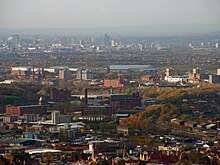
Greater Manchester is a metropolitan county and combined authority area in North West England, with a population of 2.8 million. It comprises ten metropolitan boroughs: Bolton, Bury, Oldham, Rochdale, Stockport, Tameside, Trafford, Wigan, and the cities of Manchester and Salford. Greater Manchester spans 493 square miles (1,277 km), which roughly covers the territory of the Greater Manchester Built-up Area, the second most populous urban area in the UK. It borders the ceremonial counties of Cheshire, Derbyshire, West Yorkshire and Lancashire. When you visit Greater Manchester, Walkfo brings Greater Manchester places to life as you travel by foot, bike, bus or car with a mobile phone & headphones.
Greater Manchester Places Overview: History, Culture & Facts about Greater Manchester
Visit Greater Manchester – Walkfo’s stats for the places to visit
With 131 audio plaques & Greater Manchester places for you to explore in the Greater Manchester area, Walkfo is the world’s largest heritage & history digital plaque provider. The AI continually learns & refines facts about the best Greater Manchester places to visit from travel & tourism authorities (like Wikipedia), converting history into an interactive audio experience.
Greater Manchester history
Origins
Although Greater Manchester was not created until 1974, the history of its constituent settlements goes back centuries. There is evidence of Iron Age habitation, particularly at Mellor, and Celtic activity in a settlement named Chochion, believed to have been an area of Wigan settled by the Brigantes. Stretford was also part of the land believed to have been occupied by the Celtic Brigantes tribe, and lay on their border with the Cornovii on the southern side of the River Mersey. The remains of 1st-century forts at Castlefield in Manchester, and Castleshaw Roman fort in Saddleworth, are evidence of Roman occupation. Much of the region was omitted from the Domesday Book of 1086; Redhead states that this was because only a partial survey was taken, rather than sparsity of population. During the Middle Ages, much of what became Greater Manchester lay within the hundred of Salfordshire – an ancient division of the county of Lancashire. Salfordshire encompassed several parishes and townships, some of which, like Rochdale, were important market towns and centres of England’s woollen trade. The development of what became Greater Manchester is attributed to a shared tradition of domestic flannel and fustian cloth production, which encouraged a system of cross-regional trade. In the late 18th century, the Industrial Revolution transformed the local domestic system; mechanisation enabled the industrialisation of the region’s textile trade, triggering rapid growth in the cotton industry and expansion in ancillary trades. Infrastructure such as rows of terraced housing, factories and roads were constructed to house labour, transport goods, and produce cotton goods on an industrial scale for a global market. The townships in and around Manchester began expanding “at an astonishing rate” around the turn of the 19th century as part of a process of unplanned urbanisation brought on by a boom in industrial textile production and processing. This population increase resulted in the “vigorous concentric growth” of a conurbation between Manchester and an arc of surrounding mill towns, formed from a steady accretion of houses, factories and transport infrastructure. Places such as Bury, Oldham and Bolton played a central economic role nationally, and by the end of the 19th century had become some of the most important and productive cotton-producing towns in the world. However, it was Manchester that was the most populous settlement, a major city, the world’s largest marketplace for cotton goods, and the natural centre of its region. By 1835 “Manchester was without challenge the first and greatest industrial city in the world”; and by 1848 urban sprawl had fused the city to its surrounding towns and hinterland to form a single continuous conurbation. The conurbation was “a Victorian metropolis, achieving its commercial peak during 1890–1915”. In the 1910s, local government reforms to administer this conurbation as a single entity were proposed. In the 18th century, German traders had coined the name Manchesterthum to cover the region in and around Manchester. However, the English term “Greater Manchester” did not appear until the 19th century. One of its first known recorded uses was in planning documents for the Manchester Ship Canal dated 1883, referring to “Manchester, Salford and the Out-Townships”. Use in a municipal context appeared in a 1914 report submitted in response to what was considered to have been the successful creation of the County of London in 1889. The report suggested that a county should be set up to recognise the “Manchester known in commerce”, and referred to the areas that formed “a substantial part of South Lancashire and part of Cheshire, comprising all municipal boroughs and minor authorities within a radius of eight or nine miles of Manchester”. In his 1915 book Cities in Evolution, urban planner Sir Patrick Geddes wrote “far more than Lancashire realises, is growing up another Greater London”. Most of Greater Manchester lies within the ancient county boundaries of Lancashire; those areas south of the Mersey and Tame are historically in Cheshire. The Saddleworth area and a small part of Mossley are historically part of Yorkshire and in the south-east a small part in Derbyshire. The areas that were incorporated into Greater Manchester in 1974 previously formed parts of the administrative counties of Cheshire, Lancashire, the West Riding of Yorkshire and of eight independent county boroughs. By the early 1970s, this system of demarcation was described as “archaic” and “grossly inadequate to keep pace both with the impact of motor travel, and with the huge increases in local government responsibilities”. The Manchester Evening Chronicle brought to the fore the issue of “regional unity” for the area in April 1935 under the headline “Greater Manchester – The Ratepayers’ Salvation”. It reported on the “increasing demands for the exploration of the possibilities of a greater merger of public services throughout Manchester and the surrounding municipalities”. The issue was frequently discussed by civic leaders in the area at that time, particularly those from Manchester and Salford. The Mayor of Salford pledged his support to the idea, stating that he looked forward to the day when “there would be a merging of the essential services of Manchester, Salford, and the surrounding districts constituting Greater Manchester.” Proposals were halted by the Second World War, though in the decade after it, the pace of proposals for local government reform for the area quickened. In 1947, Lancashire County Council proposed a three “ridings” system to meet the changing needs of the county of Lancashire, including those for Manchester and surrounding districts. Other proposals included the creation of a Manchester County Council, a directly elected regional body. In 1951, the census in the UK began reporting on South East Lancashire as a homogeneous conurbation.
Redcliffe-Maud Report
The Local Government Act 1958 designated the south east Lancashire area as a Special Review Area. The review was abolished in favour of the Royal Commission on Local Government before issuing a final report. The Royal Commission’s 1969 report, known as the Redcliffe-Maud Report, proposed the removal of much of the then existing system of local government. The area was to be divided into nine metropolitan districts, based on Wigan, Bolton, Bury/Rochdale, Warrington, Manchester, Oldham, Altrincham, Stockport and Tameside.
1974–1997

The Local Government Act 1972 established Greater Manchester on 1 April 1974. Greater Manchester County Council was abolished on 31 March 1986. The Association of Greater Manchester Authorities (AGMA) was established to continue much of the county-wide services of the council.
Combined Authority
In 1998, the people of Greater London voted in a referendum in favour of establishing a new Greater London Authority, with mayor and an elected chamber for the county. The New Local Government Network proposed the creation of a new Manchester City Region based on Greater Manchester and other metropolitan counties as part of on-going reform efforts. In January 2008, AGMA suggested that a formal government structure be created to cover Greater Manchester. In July 2008 the ten local authorities in Greater Manchester agreed to a strategic and integrated cross-county Multi-Area Agreement; a voluntary initiative aimed at making district councils “work together to challenge the artificial limits of boundaries”
Calls to rejoin historic counties
Residents in Saddleworth in the Borough of Oldham have called for independence from Greater Manchester and Oldham Council. A petition called for Wigan to apply for independence and rejoin Lancashire because of its heritage and location. There was a proposal for Horwich, Atherton, Blackrod and Westhoughton to form either a new part of Greater Manchester or become a separate area.
City status bids
Bolton and Stockport have made bids for city status but were unsuccessful. Stockport and Bolton have also made bids to become a city of city status.
Greater Manchester culture & places
Art, tourism, culture and sport provide 16% of employment in Greater Manchester. Art and sport provides 16% employment, with the proportion highest in Manchester. Will Straw remarked that “Greater Manchester is a creative powerhouse”
Cuisine

There are several delicacies native to Greater Manchester. Savoury dishes include black pudding, a blood sausage typically associated with Bury and Bury Market; pasty barm, a combined pasty-barm cake created in Bolton. Sweet dishes include Eccles cake — native to Eccles — a small round flaky pastry cake filled with currants, sugar and spice.
Galleries, museums and exhibitions
Greater Manchester Museums Group (GMMG) is a partnership of eight of the ten Museum Services in Greater Manchester. Its museums showcase the county’s industrial and social heritage. The Hat Works in Stockport is the UK’s only museum dedicated to the hatting industry. Manchester Art Gallery is a major provincial art gallery noted for its collection of Pre-Raphaelite art.
Media, film and television
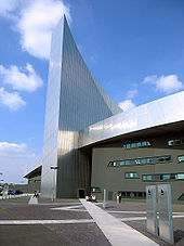
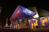
MediaCityUK is a 200-acre (81 ha) mixed-use property development site at Salford Quays. Principal tenants are mass media organisations such as ITV Granada and BBC. The Greater Manchester Film Festival was launched in 2012. The Manchester Evening News is a regional daily newspaper covering Greater Manchester.
Music, theatre and performing arts
Greater Manchester has the highest number of theatre seats per head of population outside London. Most of the larger theatres are subsidised by local authorities or the North West Regional Arts Board. Oldham Playhouse helped launch the careers of Stan Laurel and Charlie Chaplin.
Greater Manchester geography / climate
Greater Manchester is a landlocked county spanning 493 square miles (1,277 km) The Pennines rise to the north and east of the county with the West Pennine Moors in the northwest, the South Pennines in the northeast and the Peak District in the east. The rivers Mersey, Irwell and Tame run through Greater Manchester, all of which rise in the Pennines. The built environment of Greater Manchester utilises red brick and sandstone prominently as a building material.
Climate
Greater Manchester experiences a temperate maritime climate, like most of the British Isles, with relatively cool summers and mild winters. The county’s average annual rainfall is 806.6 millimetres (31.76 in) compared to the UK average of 1,125.0 mm (44.29 in) and its mean rain days are 140.4 mm (5.53 in) per annum.
Flora and fauna
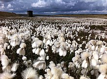
Greater Manchester has a “wide and varied range” of wildlife and natural habitats. The wooded valleys of Bolton, Bury and Stockport, the moorlands north and east of Rochdale, Oldham and Stalybridge, and the reed beds between Wigan and Leigh, harbour flora and fauna of national importance. The 21 Sites of Special Scientific Interest in Greater Manchester are of particular interest to organisations dedicated to wildlife conservation.
Why visit Greater Manchester with Walkfo Travel Guide App?
 You can visit Greater Manchester places with Walkfo Greater Manchester to hear history at Greater Manchester’s places whilst walking around using the free digital tour app. Walkfo Greater Manchester has 131 places to visit in our interactive Greater Manchester map, with amazing history, culture & travel facts you can explore the same way you would at a museum or art gallery with information audio headset. With Walkfo, you can travel by foot, bike or bus throughout Greater Manchester, being in the moment, without digital distraction or limits to a specific walking route. Our historic audio walks, National Trust interactive audio experiences, digital tour guides for English Heritage locations are available at Greater Manchester places, with a AI tour guide to help you get the best from a visit to Greater Manchester & the surrounding areas.
“Curated content for millions of locations across the UK, with 131 audio facts unique to Greater Manchester places in an interactive Greater Manchester map you can explore.”
Walkfo: Visit Greater Manchester Places Map
131 tourist, history, culture & geography spots
Greater Manchester historic spots | Greater Manchester tourist destinations | Greater Manchester plaques | Greater Manchester geographic features |
| Walkfo Greater Manchester tourism map key: places to see & visit like National Trust sites, Blue Plaques, English Heritage locations & top tourist destinations in Greater Manchester | |||
Best Greater Manchester places to visit
Greater Manchester has places to explore by foot, bike or bus. Below are a selection of the varied Greater Manchester’s destinations you can visit with additional content available at the Walkfo Greater Manchester’s information audio spots:

Church of the Ascension, Lower Broughton
The Church of the Ascension is a Grade II listed Anglican church in Lower Broughton, Salford, England. In February 2017 a fire destroyed the roof and interior of the building.

Pendlebury (ward)
Pendlebury is an electoral ward of Salford, England. It is represented in Westminster by Rebecca Long-Bailey MP Rebecca Long Bailey. A profile of the ward conducted in 2014 recorded a population of 13,434.
![]()
Real Radio XS
Real Radio XS was a radio station brand operated by Real and Smooth Ltd (formerly GMG Radio) based in Salford, Greater Manchester, broadcasting a variety of peak-time news, rock music and talk output. The Manchester-based version of the service was broadcast to Greater Manchester on FM, and to a number of areas on DAB.

Irwell Riverside (ward)
Irwell Riverside (ward) is an electoral ward of Salford, England. The ward is bounded by meanders of the River Irwell and includes the main university campus. It is represented in Westminster by Rebecca Long-Bailey MP for Salfords and Eccles.
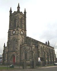
St Thomas’ Church, Pendleton
St Thomas’ Church is on Broad Street, Pendleton, Salford, Greater Manchester. It was a Commissioners’ church, having received a grant towards its construction from the Church Building Commission. It is designated by English Heritage as a Grade II listed building.

Greater Manchester Built-up Area
The Greater Manchester Built-up Area has a population of 2,553,379 according to the United Kingdom Census 2011. It is the second most populous conurbation in the UK after the Greater London built-up area. The area is not conterminous with Greater Manchester, for it excludes settlements such as Wigan and Marple from Greater Manchester.

HM Prison Forest Bank
HM Prison Forest Bank is a Category B men’s private prison. It is located in the Agecroft area of Pendlebury in Salford near Manchester. The prison is operated by Sodexo Justice Services.

Irlams o’ th’ Height
Irlams o’ th’ Height is a suburb of Salford, Greater Manchester, England. It is located in the centre of the city’s population.

Salford Acoustics
Salford Acoustics is based in two locations: (i) 3 km west of Manchester city centre, UK, and (ii) on the banks of the Manchester Ship Canal at MediaCityUK. It undertakes public and industrial research in acoustics and carries out commercial testing.

Langworthy (ward)
Langworthy (ward) is an electoral ward of Salford, England. It is represented in Westminster by Rebecca Long-Bailey MP Rebecca Long Bailey. A profile of the ward recorded a population of 12,980 in 2014.
Visit Greater Manchester plaques
 56
56
plaques
here Greater Manchester has 56 physical plaques in tourist plaque schemes for you to explore via Walkfo Greater Manchester plaques audio map when visiting. Plaques like National Heritage’s “Blue Plaques” provide visual geo-markers to highlight points-of-interest at the places where they happened – and Walkfo’s AI has researched additional, deeper content when you visit Greater Manchester using the app. Experience the history of a location when Walkfo local tourist guide app triggers audio close to each Greater Manchester plaque. Explore Plaques & History has a complete list of Hartlepool’s plaques & Hartlepool history plaque map.


 Trying to encourage visitors to Greater Manchester?