Welcome to Visit County Tipperary Places
The Walkfo guide to things to do & explore in County Tipperary
 Visit County Tipperary places using Walkfo for free guided tours of the best County Tipperary places to visit. A unique way to experience County Tipperary’s places, Walkfo allows you to explore County Tipperary as you would a museum or art gallery with audio guides.
Visiting County Tipperary Walkfo Preview
County Tipperary (Irish: Contae Thiobraid Árann) is a county in Munster. It was established in the early thirteenth century, shortly after the Norman invasion of Ireland. The population of the county was 159,553 at the 2016 census. The largest towns are Clonmel, Nenagh and Thurles. When you visit County Tipperary, Walkfo brings County Tipperary places to life as you travel by foot, bike, bus or car with a mobile phone & headphones.
County Tipperary Places Overview: History, Culture & Facts about County Tipperary
Visit County Tipperary – Walkfo’s stats for the places to visit
With 8 audio plaques & County Tipperary places for you to explore in the County Tipperary area, Walkfo is the world’s largest heritage & history digital plaque provider. The AI continually learns & refines facts about the best County Tipperary places to visit from travel & tourism authorities (like Wikipedia), converting history into an interactive audio experience.
County Tipperary history

In 1328, Tipperary was granted to the Earls of Ormond as a county palatine or liberty. The grant excluded church lands such as the archiepiscopal see of Cashel. The county was divided once again in 1838. The Local Government Reform Act 2014 has amalgamated the two counties.
County Tipperary culture & places

Tipperary is referred to as the “Premier County”, a description attributed to Thomas Davis, Editor of The Nation newspaper in the 1840s. The county was the subject of the famous song “It’s a Long Way to Tipperry” written by Jack Judge. It was popular with regiments of the British Army during World War I.
County Tipperary geography / climate
Tipperary is a part of the Golden Vale in the south-west. The Galty mountains are the highest range, with Galtymore at 917m high. Other mountain ranges include the Silvermine Mountains, the Arra Mountains and the Knockmealdown Mountains.
Why visit County Tipperary with Walkfo Travel Guide App?
 You can visit County Tipperary places with Walkfo County Tipperary to hear history at County Tipperary’s places whilst walking around using the free digital tour app. Walkfo County Tipperary has 8 places to visit in our interactive County Tipperary map, with amazing history, culture & travel facts you can explore the same way you would at a museum or art gallery with information audio headset. With Walkfo, you can travel by foot, bike or bus throughout County Tipperary, being in the moment, without digital distraction or limits to a specific walking route. Our historic audio walks, National Trust interactive audio experiences, digital tour guides for English Heritage locations are available at County Tipperary places, with a AI tour guide to help you get the best from a visit to County Tipperary & the surrounding areas.
“Curated content for millions of locations across the UK, with 8 audio facts unique to County Tipperary places in an interactive County Tipperary map you can explore.”
Walkfo: Visit County Tipperary Places Map
8 tourist, history, culture & geography spots
County Tipperary historic spots | County Tipperary tourist destinations | County Tipperary plaques | County Tipperary geographic features |
| Walkfo County Tipperary tourism map key: places to see & visit like National Trust sites, Blue Plaques, English Heritage locations & top tourist destinations in County Tipperary | |||
Best County Tipperary places to visit
County Tipperary has places to explore by foot, bike or bus. Below are a selection of the varied County Tipperary’s destinations you can visit with additional content available at the Walkfo County Tipperary’s information audio spots:

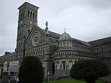
Cathedral of the Assumption, Thurles
The Cathedral of the Assumption is the mother church of the Metropolitan Province of Cashel. It stands on the site of earlier chapels, which were the only Roman Catholic churches in Thurles, County Tipperary. It is the cathedra of the Archbishop of. Cashel and Emly. James Butler II (1774–91), on being appointed by the Holy See, moved his residence and cathedrra from Cashel, favouring Thurles.
Roman Catholic Archdiocese of Cashel and Emly
The Archdiocese of Cashel and Emly is the metropolis of the eponymous ecclesiastical province. The incumbent archbishop of the archdiocese is Kieran O’Reilly. The Cathedral of the Assumption is in Thurles, County Tipperary.

Thurles Sarsfields GAA
Thurles Sarsfields is a GAA club which is located in County Tipperary, Ireland. Both hurling and Gaelic football are played in the “Mid-Tipperary” divisional competitions. The club is centred in the town of Thurles at Semple Stadium.
Visit County Tipperary plaques
 0
0
plaques
here County Tipperary has 0 physical plaques in tourist plaque schemes for you to explore via Walkfo County Tipperary plaques audio map when visiting. Plaques like National Heritage’s “Blue Plaques” provide visual geo-markers to highlight points-of-interest at the places where they happened – and Walkfo’s AI has researched additional, deeper content when you visit County Tipperary using the app. Experience the history of a location when Walkfo local tourist guide app triggers audio close to each County Tipperary plaque. Currently No Physical Plaques.


 Trying to encourage visitors to County Tipperary?