Welcome to Visit Blackburn Places
The Walkfo guide to things to do & explore in Blackburn
 Visit Blackburn places using Walkfo for free guided tours of the best Blackburn places to visit. A unique way to experience Blackburn’s places, Walkfo allows you to explore Blackburn as you would a museum or art gallery with audio guides.
Visiting Blackburn Walkfo Preview
Blackburn is located 8 miles (13 km) east of Preston and 20.9 miles (34 km) north-northwest of Manchester. It is bounded to the south by Darwen, with which it forms the unitary authority of Blackburn with Darwen. When you visit Blackburn, Walkfo brings Blackburn places to life as you travel by foot, bike, bus or car with a mobile phone & headphones.
Blackburn Places Overview: History, Culture & Facts about Blackburn
Visit Blackburn – Walkfo’s stats for the places to visit
With 50 audio plaques & Blackburn places for you to explore in the Blackburn area, Walkfo is the world’s largest heritage & history digital plaque provider. The AI continually learns & refines facts about the best Blackburn places to visit from travel & tourism authorities (like Wikipedia), converting history into an interactive audio experience.
Blackburn history
Toponymy
Blackburn was recorded in the Domesday Book as Blacheborne in 1086. By 1610, the spelling of the town is Blackburn, while the region was Blackburne. Local author William Abram cited the ancient name as Blake Burne in 1877 book.
Prehistory
In 1879, a cinerary urn was discovered at a tumulus at Revidge, north of Blackburn. Another was excavated in 1996 at Pleasington Cemetery, west of the town. There is little evidence of prehistoric settlement in the Blakewater valley.
Roman era
Blackburn is located where a Roman military road crossed the river Blakewater. The road linked Bremetennacum Veteranorum (Ribchester) and Mamucium (a major Roman fort) The route of the road passed east of Blackburn Cathedral. It is not clear whether the road predated the settlement.
Middle Ages

Christianity is believed to have come to Blackburn by the end of the 6th century. The name of the town appears in the Domesday Book as Blachebourne, a royal manor during the days of Edward the Confessor and William the Conqueror. During the 12th century, the town’s importance declined as Clitheroe became the regional centre.
Industrial Revolution and textiles
Textile manufacturing in Blackburn dates from the mid-13th century, when wool produced locally by farmers was woven in their homes. Flemish weavers who settled in the area in the 14th century developed the industry. By 1650 the town was known for the manufacture of blue and white “Blackburn checks”
1800s
In 1807, Daniel Thwaites & Co brewery was established; the company is still in business today. Improvements to the power loom in the early 1840s led to greater investment in power looms in Blackburn. The railway brought opportunities for expansion of the cotton trade, and in subsequent decades many new mills were constructed.
20th-century decline of the cotton industry
In 1890, Blackburn’s Chamber of Commerce warned of the dangers of ‘only having one string to their bow in Blackburn’ In 1904, a slump hit the cotton industry and other industries dependent on it, such as engineering, brewing and building. In 1908, another slump saw 43 mills stop production and a quarter of the town’s looms lay idle. In 1926, the General Strike saw production suspended at half of Blackburn’s mills and 12,000 unemployed. In 1930, 50 mills had shut and 21,000 people were unemployed, with 1,000 houses and 166 shops lying empty in the town.
Blackburn landmarks
Cathedral

Blackburn Cathedral was formerly St Mary’s Parish Church. It was reconsecrated in 1826 on the site of a previous church that had stood for several hundred years. In 1926 the Diocese of Blackburn was created and the church gained cathedral status.
Ewood Park
The ground was opened in AprIl 1882. Work on the redeveloped, all-seater stadium got underway in February 1993 when the old Darwen End stand was demolished. Almost two years later, on 18 November 1995, the new Ewood Park was officially opened.
Queen Victoria’s statue

Blackburn’s statue of Queen Victoria is 11 feet (3.4 m) high and weighs 9 long tons (9.1 t) Victoria’s fourth daughter, Princess Louise, Duchess of Argyll, unveiled the statue on 30 September 1905.
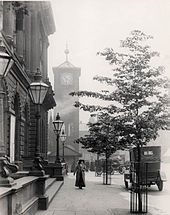
Town Hall

The construction of Blackburn’s original, Italian Renaissance style Town Hall was completed in 1856. It originally housed a police station with 18 cells, a large assembly room, and a council chamber. A tower block extension was constructed in 1969 at a cost of £650,000, equal to about £6.6 million. The two buildings are connected only by an elevated, enclosed footbridge.
Technical School

The Prince and Princess of Wales laid the foundation stone of the Technical School building in 1888. It is built in the Northern Renaissance style and has a slate roof, an attic, a basement and two intermediate storeys. Grade II listed building is now part of Blackburn College.
Other landmarks

Blackburn railway station features a 24-foot (7.3 m) mural by Stephen Charnock. The Wainwright Bridge was opened in June 2008 and forms part of the A6078 Town Centre Orbital Route. BBC Radio Lancashire has studios in Darwen Street in the town centre.
Parks

Corporation Park was built on 20 hectares (50 acres) of land bought from Joseph Feilden, lord of the manor, for £50 per 1 acre (0.40 ha) in 1855. Queen’s Park was laid out at a cost of £10,000 on land acquired by Blackburn Corporation from the Ecclesiastical Commissioners in 1882. Witton Country Park is a 190-hectare (480-acre) space to the west of the town. Roe Lee Park was opened on Wednesday 30 May 1923 to commemorate a visit by George V.
Libraries
Blackburn Central Library is located in the town centre close to the Town Hall. The library has various sections and facilities, including an information and reference section. An ICT training suite at the library has been named the “Bill Gates Room”
Blackburn geography / climate
Blackburn is located at 53°44′41′41″N 2°28′37″W / 53.74472°N 2.47694°W – -2.4769°. The town is located 8.9 miles (14.3 km) east of Preston and 21 miles (34 km) north-northeast of Manchester. The city of Preston is 9.2 miles (15 km) to the west, Blackburn is the largest municipality in East Lancashire.
Geology and terrain

The town centre centres in a plain of 91–110 m above sea level surrounded by hills. The Revidge to the north can be reached via a steep climb up Montague Street and Dukes Brow to reach a peak of 218 metres (715 ft) The River Blakewater flows down from the moors above Guide and then through Whitebirk, Little Harwood, Cob Wall and Brookhouse to the town centre. The geology of the Blackburn area yields numerous resources which underpinned its development as a centre of manufacturing.
Why visit Blackburn with Walkfo Travel Guide App?
 You can visit Blackburn places with Walkfo Blackburn to hear history at Blackburn’s places whilst walking around using the free digital tour app. Walkfo Blackburn has 50 places to visit in our interactive Blackburn map, with amazing history, culture & travel facts you can explore the same way you would at a museum or art gallery with information audio headset. With Walkfo, you can travel by foot, bike or bus throughout Blackburn, being in the moment, without digital distraction or limits to a specific walking route. Our historic audio walks, National Trust interactive audio experiences, digital tour guides for English Heritage locations are available at Blackburn places, with a AI tour guide to help you get the best from a visit to Blackburn & the surrounding areas.
“Curated content for millions of locations across the UK, with 50 audio facts unique to Blackburn places in an interactive Blackburn map you can explore.”
Walkfo: Visit Blackburn Places Map
50 tourist, history, culture & geography spots
Blackburn historic spots | Blackburn tourist destinations | Blackburn plaques | Blackburn geographic features |
| Walkfo Blackburn tourism map key: places to see & visit like National Trust sites, Blue Plaques, English Heritage locations & top tourist destinations in Blackburn | |||
Best Blackburn places to visit
Blackburn has places to explore by foot, bike or bus. Below are a selection of the varied Blackburn’s destinations you can visit with additional content available at the Walkfo Blackburn’s information audio spots:
Visit Blackburn plaques
 16
16
plaques
here Blackburn has 16 physical plaques in tourist plaque schemes for you to explore via Walkfo Blackburn plaques audio map when visiting. Plaques like National Heritage’s “Blue Plaques” provide visual geo-markers to highlight points-of-interest at the places where they happened – and Walkfo’s AI has researched additional, deeper content when you visit Blackburn using the app. Experience the history of a location when Walkfo local tourist guide app triggers audio close to each Blackburn plaque. Explore Plaques & History has a complete list of Hartlepool’s plaques & Hartlepool history plaque map.


 Trying to encourage visitors to Blackburn?