Welcome to Visit Glasgow Places
The Walkfo guide to things to do & explore in Glasgow
 Visit Glasgow places using Walkfo for free guided tours of the best Glasgow places to visit. A unique way to experience Glasgow’s places, Walkfo allows you to explore Glasgow as you would a museum or art gallery with audio guides.
Visiting Glasgow Walkfo Preview
Glasgow is the fourth-most populous city in the United Kingdom and the 27th largest city by population in Europe. Historically part of Lanarkshire, the city now forms the Glasgow City council area, one of the 32 council areas of Scotland, and is governed by Glasgow City Council. It is situated on the River Clyde in the country’s West Central Lowlands. The city was the European Capital of Culture in 1990 and is notable for its architecture, culture, media, music scene, sports clubs and transport connections. When you visit Glasgow, Walkfo brings Glasgow places to life as you travel by foot, bike, bus or car with a mobile phone & headphones.
Glasgow Places Overview: History, Culture & Facts about Glasgow
Visit Glasgow – Walkfo’s stats for the places to visit
With 424 audio plaques & Glasgow places for you to explore in the Glasgow area, Walkfo is the world’s largest heritage & history digital plaque provider. The AI continually learns & refines facts about the best Glasgow places to visit from travel & tourism authorities (like Wikipedia), converting history into an interactive audio experience.
Glasgow history
Origins and development
The area around Glasgow has hosted communities for millennia, with the River Clyde providing a natural location for fishing. The Romans later built outposts in the area and, to protect Roman Britannia from the Brittonic speaking (Celtic) Caledonians, constructed the Antonine Wall. Glasgow itself was reputed to have been founded by the Christian missionary Saint Mungo in the 6th century.
Trading port
In 1668, the city’s Tobacco Lords created a deep water port at Port Glasgow about 20 mi (32 km) down the River Clyde. After the Acts of Union in 1707, Scotland gained further access to the vast markets of the new British Empire. At the time, Glasgow held a commercial importance as the city participated in the trade of sugar, tobacco and later cotton.
Industrialisation

The opening of the Monkland Canal and basin linking to the Forth and Clyde Canal at Port Dundas in 1795, facilitated access to the extensive iron-ore and coal mines in Lanarkshire. After extensive river engineering projects to dredge and deepen the River Clyde as far as Glasgow, shipbuilding became a major industry on the upper stretches of the river, pioneered by industrialists such as Robert Napier, John Elder, George Thomson, Sir William Pearce and Sir Alfred Yarrow. The River Clyde also became an important source of inspiration for artists, such as John Atkinson Grimshaw, John Knox, James Kay, Sir Muirhead Bone, Robert Eadie and L.S. Lowry, willing to depict the new industrial era and the modern world, as did Stanley Spencer downriver at Port Glasgow. Glasgow’s population had surpassed that of Edinburgh by 1821. The development of civic institutions included the City of Glasgow Police in 1800, one of the first municipal police forces in the world. Despite the crisis caused by the City of Glasgow Bank’s collapse in 1878, growth continued and by the end of the 19th century it was one of the cities known as the “Second City of the Empire” and was producing more than half Britain’s tonnage of shipping and a quarter of all locomotives in the world. In addition to its pre-eminence in shipbuilding, engineering, industrial machinery, bridge building, chemicals, explosives, coal and oil industries it developed as a major centre in textiles, garment-making, carpet manufacturing, leather processing, furniture-making, pottery, food, drink and cigarette making; printing and publishing. Shipping, banking, insurance and professional services expanded at the same time. Glasgow became one of the first cities in Europe to reach a population of one million. The city’s new trades and sciences attracted new residents from across the Lowlands and the Highlands of Scotland, from Ireland and other parts of Britain and from Continental Europe. During this period, the construction of many of the city’s greatest architectural masterpieces and most ambitious civil engineering projects, such as the Milngavie water treatment works, Glasgow Subway, Glasgow Corporation Tramways, City Chambers, Mitchell Library and Kelvingrove Art Gallery and Museum were being funded by its wealth. The city also held a series of International Exhibitions at Kelvingrove Park, in 1888, 1901 and 1911, with Britain’s last major International Exhibition, the Empire Exhibition, being subsequently held in 1938 at Bellahouston Park, which drew 13 million visitors. The 20th century witnessed both decline and renewal in the city. After World War I, the city suffered from the impact of the Post–World War I recession and from the later Great Depression, this also led to a rise of radical socialism and the “Red Clydeside” movement. The city had recovered by the outbreak of World War II. The city saw aerial bombardment by the Luftwaffe during the Clydebank Blitz, during the war, then grew through the post-war boom that lasted through the 1950s. By the 1960s, growth of industry in countries like Japan and West Germany, weakened the once pre-eminent position of many of the city’s industries. As a result of this, Glasgow entered a lengthy period of relative economic decline and rapid de-industrialisation, leading to high unemployment, urban decay, population decline, welfare dependency and poor health for the city’s inhabitants. There were active attempts at regeneration of the city, when the Glasgow Corporation published its controversial Bruce Report, which set out a comprehensive series of initiatives aimed at turning round the decline of the city. The report led to a huge and radical programme of rebuilding and regeneration efforts that started in the mid-1950s and lasted into the late 1970s. This involved the mass demolition of the city’s infamous slums and their replacement with large suburban housing estates and tower blocks. The city invested heavily in roads infrastructure, with an extensive system of arterial roads and motorways that bisected the central area. There are also accusations that the Scottish Office had deliberately attempted to undermine Glasgow’s economic and political influence in post-war Scotland by diverting inward investment in new industries to other regions during the Silicon Glen boom and creating the new towns of Cumbernauld, Glenrothes, Irvine, Livingston and East Kilbride, dispersed across the Scottish Lowlands to halve the city’s population base. By the late 1980s, there had been a significant resurgence in Glasgow’s economic fortunes. The “Glasgow’s miles better” campaign, launched in 1983, and opening of the Burrell Collection in 1983 and Scottish Exhibition and Conference Centre in 1985 facilitated Glasgow’s new role as a European centre for business services and finance and promoted an increase in tourism and inward investment. The latter continues to be bolstered by the legacy of the city’s Glasgow Garden Festival in 1988, its status as European Capital of Culture in 1990, and concerted attempts to diversify the city’s economy. However, it is the industrial heritage that serves as key tourism enabler. Wider economic revival has persisted and the ongoing regeneration of inner-city areas, including the large-scale Clyde Waterfront Regeneration, has led to more affluent people moving back to live in the centre of Glasgow, fuelling allegations of gentrification. In 2008, the city was listed by Lonely Planet as one of the world’s top 10 tourist cities. Despite Glasgow’s economic renaissance, the East End of the city remains the focus of social deprivation. A Glasgow Economic Audit report published in 2007 stated that the gap between prosperous and deprived areas of the city is widening. In 2006, 47% of Glasgow’s population lived in the most deprived 15% of areas in Scotland, while the Centre for Social Justice reported 29.4% of the city’s working-age residents to be “economically inactive”. Although marginally behind the UK average, Glasgow still has a higher employment rate than Birmingham, Liverpool and Manchester. In 2008 the city was ranked at 43 for Personal Safety in the Mercer index of top 50 safest cities in the world. The Mercer report was specifically looking at Quality of Living, yet by 2011 within Glasgow, certain areas were (still) “failing to meet the Scottish Air Quality Objective levels for nitrogen dioxide (NO2) and particulate matter (PM10)”.
Sanitation
The first scheme to provide a public water supply was by the Glasgow Company in 1806. A second company was formed in 1812, and the two merged in 1838, but there was some dissatisfaction with the quality of the water supplied. This led to the development of the Glasgow Corporation Water Works, with a project to raise the level of Loch Katrine and convey clean water by gravity along a 26 mi (42 km) aqueduct to a holding reservoir at Milngavie, and then by pipes into the city. The project cost £980,000 and was opened by Queen Victoria in 1859.
Heraldry
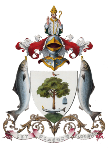
The coat of arms of the City of Glasgow was granted to the royal burgh by the Lord Lyon on 25 October 1866. It incorporates a number of symbols and emblems associated with the life of Glasgow’s patron saint, Mungo, which had been used on official seals prior to that date. The supporters are two salmon bearing rings, and the crest is a half length figure of Saint. The original 1866 grant placed the crest atop a helm but this was removed in subsequent grants.
Glasgow culture & places

Glasgow was designated European Capital of Culture in 1990. Mitchell Library is one of the largest public reference libraries in Europe. Most of Scotland’s national arts organisations are based in Glasgow, including Scottish Opera, Scottish Ballet and Royal Scottish National Orchestra.
Recreation
Glasgow is home to many museums and art galleries, the largest and most famous being the Kelvingrove Art Gallery and Museum, the Hunterian Museum and Art Gallery, the Gallery of Modern Art (GoMA) and the Burrell Collection. Most of the museums and galleries in Glasgow are publicly owned and free to enter. The city has hosted many exhibitions over the years, including The Glasgow Garden Festival in 1988.
Music scene

The city of Glasgow was appointed a UNESCO City of Music on 20 August 2008 as part of the Creative Cities Network. The city is home to numerous orchestras, ensembles and bands including those of Scottish Opera, Scottish Ballet, Royal Scottish National Orchestra, BBC Scottish Symphony Orchestra and related to the Royal Conservatoire of Scotland.
Media

There have been hundreds of films made about Glasgow or in Glasgow. Both BBC Scotland and STV have their headquarters in the city. The Scottish press publishes various newspapers in Glasgow such as the Evening Times, The Herald, The Sunday Herald and the Sunday Mail.
Religion
Glasgow is a city of significant religious diversity. The Church of Scotland and Roman Catholic Church are the two largest Christian denominations in the city. The Protestant churches are the largest in number, including Baptist, Episcopalian, Methodist and Presbyterian. Glasgow Central Mosque in the Gorbals district is the largest mosque in Scotland. The city has four Christian cathedrals: Glasgow Cathedral, St Andrew’s Cathedral; St Mary’s Cathedral, of the Scottish Episcopal Church, and St Luke’s Cathedral.
Language
Glasgow is Scotland’s main locus of Gaelic language use outside the Highlands and Islands. In 2011, 5,878 residents of the city over age 3 spoke Gaelic, amounting to 1.0% of the population. Only Inverness, unofficial capital of the Highlands, has a larger percentage of speakers.
Architecture

Very little of medieval Glasgow remains; the two main landmarks from this period are the 15th century Provand’s Lordship and 13th century St. Mungo’s Cathedral. The vast majority of the central city area as seen today dates from the 19th century. The city is notable for architecture designed by the Glasgow School, most notable exponent of that style being Charles Rennie Mackintosh.
Glasgow etymology
The name Glasgow is Brittonic in origin, with the first element being glas, meaning “grey-green, grey-blue”, and the second *cöü, “hollow”, giving a meaning of “green-hollow” The settlement probably had an earlier Cumbric name, Cathures. The modern name appears for the first time in the Gaelic period (1116), as Glasgu.
Glasgow geography / climate
Glasgow is located on the banks of the River Clyde, in West Central Scotland. Its second most important river is the Kelvin whose name was used in creating the title of Baron Kelvin the renowned physicist.
Location

Glasgow is located in the central belt of Scotland. It is located on the outskirts of Glasgow. Glasgow is the capital of Glasgow, Scotland, and is a city in central Scotland.
Climate

Despite its northerly latitude, similar to that of Moscow, Glasgow’s climate is classified as oceanic (Köppen Cfb) At Paisley, the annual precipitation averages 1,245 mm (49.0 in) Glasgow has been named as the rainiest city of the UK, having an average of 170 days of rain a year.
Why visit Glasgow with Walkfo Travel Guide App?
 You can visit Glasgow places with Walkfo Glasgow to hear history at Glasgow’s places whilst walking around using the free digital tour app. Walkfo Glasgow has 424 places to visit in our interactive Glasgow map, with amazing history, culture & travel facts you can explore the same way you would at a museum or art gallery with information audio headset. With Walkfo, you can travel by foot, bike or bus throughout Glasgow, being in the moment, without digital distraction or limits to a specific walking route. Our historic audio walks, National Trust interactive audio experiences, digital tour guides for English Heritage locations are available at Glasgow places, with a AI tour guide to help you get the best from a visit to Glasgow & the surrounding areas.
“Curated content for millions of locations across the UK, with 424 audio facts unique to Glasgow places in an interactive Glasgow map you can explore.”
Walkfo: Visit Glasgow Places Map
424 tourist, history, culture & geography spots
Glasgow historic spots | Glasgow tourist destinations | Glasgow plaques | Glasgow geographic features |
| Walkfo Glasgow tourism map key: places to see & visit like National Trust sites, Blue Plaques, English Heritage locations & top tourist destinations in Glasgow | |||
Best Glasgow places to visit
Glasgow has places to explore by foot, bike or bus. Below are a selection of the varied Glasgow’s destinations you can visit with additional content available at the Walkfo Glasgow’s information audio spots:

Strathbungo
Strathbungo grew up as a small village built along the Pollokshaws Road, one of the main arteries leading southwards from the centre of Glasgow, adjoined by the Camphill Estate, now part of Queens Park. The feudal superiors, the Maxwells of Pollok, preferred the name Marchtown, and this name is seen on some old maps.

St Andrew’s Cross, Glasgow
St Andrew’s Cross, also known as Eglinton Toll, is a road junction in the south side of Glasgow, Scotland. The junction is known as the St Andrew Cross.

Tradeston
Tradeston (Scots: Tredstoun) is a small district in the Scottish city of Glasgow adjacent to the city centre on the south bank of the River Clyde.
Moorepark, Glasgow
Moorepark is a small area in the Scottish city of Glasgow. Situated south of the River Clyde and part of the former Burgh of Govan. It was colloquially referred to as ‘Wine Alley’ during the 20th century.

Sandyford, Glasgow
Sandyford is north of the River Clyde and forms part of the western periphery of Glasgow. Formerly the name of a ward under Glasgow Town Council in the early 20th century. It is within a continuous area of dense urban development bordering several other neighbourhoods.
Athletes’ Village (Glasgow 2014)
The Athletes Village for the 2014 Commonwealth Games was situated on a 35-hectare (86-acre) site, in the east end of Glasgow. The site was used as accommodation for up to 8,000 athletes and officials from all over the Commonwealth nations. After the games, the site was further developed and has up to 1,400 homes, a portion of which are available for social rental.
Carntyne
Carntyne (Scottish Gaelic: Càrn an Teine) is a suburban district in the Scottish city of Glasgow. It is situated north of the River Clyde, and in the east end of the city. It has formed the core of the East Centre ward under Glasgow City Council since 2007.

1990 Auckland Jewish daycare stabbing
A mentally ill woman attacked the playground of the Jewish Kadimah School’s daycare in Central Auckland, stabbing four children with a knife. The attack continued as other young students looked on “in horror”, while members of staff ran to help the children. The woman, 52-year-old Pauline Janet Williamson, was eventually disarmed by a male teacher. The children, aged 6 to 8, were hospitalised immediately afterwards.

Tradeston Flour Mills explosion
The Tradeston Flour Mills exploded on 9 July 1872. Eighteen people died and at least 16 were injured. The mill was owned by Matthew Muir & Sons and had been in operation for 30 years.

Equestrian statue of William III, Glasgow
The equestrian statue of William III in Cathedral Square, Glasgow, is a 1735 work by an unknown sculptor. It is the work of a sculptor unknown.
Visit Glasgow plaques
 68
68
plaques
here Glasgow has 68 physical plaques in tourist plaque schemes for you to explore via Walkfo Glasgow plaques audio map when visiting. Plaques like National Heritage’s “Blue Plaques” provide visual geo-markers to highlight points-of-interest at the places where they happened – and Walkfo’s AI has researched additional, deeper content when you visit Glasgow using the app. Experience the history of a location when Walkfo local tourist guide app triggers audio close to each Glasgow plaque. Explore Plaques & History has a complete list of Hartlepool’s plaques & Hartlepool history plaque map.


 Trying to encourage visitors to Glasgow?