Welcome to Visit Wythenshawe Places
The Walkfo guide to things to do & explore in Wythenshawe
 Visit Wythenshawe places using Walkfo for free guided tours of the best Wythenshawe places to visit. A unique way to experience Wythenshawe’s places, Walkfo allows you to explore Wythenshawe as you would a museum or art gallery with audio guides.
Visiting Wythenshawe Walkfo Preview
Wythenshawe was transferred to the City of Manchester in 1931. It was, at one time, the largest council estate in Europe. It includes estates of Baguley, Benchill, Brooklands, Peel Hall, Newall Green, Woodhouse Park, Moss Nook, Northern Moor, Northenden and Sharston. When you visit Wythenshawe, Walkfo brings Wythenshawe places to life as you travel by foot, bike, bus or car with a mobile phone & headphones.
Wythenshawe Places Overview: History, Culture & Facts about Wythenshawe
Visit Wythenshawe – Walkfo’s stats for the places to visit
With 87 audio plaques & Wythenshawe places for you to explore in the Wythenshawe area, Walkfo is the world’s largest heritage & history digital plaque provider. The AI continually learns & refines facts about the best Wythenshawe places to visit from travel & tourism authorities (like Wikipedia), converting history into an interactive audio experience.
Wythenshawe history

The name of Wythenshawe seems to come from the Old English wiðign = “withy tree” and sceaga = “wood” The three ancient townships of Northenden, Baguley and Northen Etchells formally became the present-day Wythen Shawe when they were merged with Manchester in 1931. The name refers to the town’s hall and grounds, which was temporarily closed to the public in 2010 due to spending cuts.
Wythenshawe geography / climate
Wythenshawe is 8 miles (13 km) south of the city centre and is the southernmost district of Manchester. It is surrounded by some of the most affluent areas in the UK. Shadow Moss is an area south of Ringway Road in the southeast corner. For many centuries it was a peat bog dug for peat fuel, locally called “turf”
Why visit Wythenshawe with Walkfo Travel Guide App?
 You can visit Wythenshawe places with Walkfo Wythenshawe to hear history at Wythenshawe’s places whilst walking around using the free digital tour app. Walkfo Wythenshawe has 87 places to visit in our interactive Wythenshawe map, with amazing history, culture & travel facts you can explore the same way you would at a museum or art gallery with information audio headset. With Walkfo, you can travel by foot, bike or bus throughout Wythenshawe, being in the moment, without digital distraction or limits to a specific walking route. Our historic audio walks, National Trust interactive audio experiences, digital tour guides for English Heritage locations are available at Wythenshawe places, with a AI tour guide to help you get the best from a visit to Wythenshawe & the surrounding areas.
“Curated content for millions of locations across the UK, with 87 audio facts unique to Wythenshawe places in an interactive Wythenshawe map you can explore.”
Walkfo: Visit Wythenshawe Places Map
87 tourist, history, culture & geography spots
Wythenshawe historic spots | Wythenshawe tourist destinations | Wythenshawe plaques | Wythenshawe geographic features |
| Walkfo Wythenshawe tourism map key: places to see & visit like National Trust sites, Blue Plaques, English Heritage locations & top tourist destinations in Wythenshawe | |||
Best Wythenshawe places to visit
Wythenshawe has places to explore by foot, bike or bus. Below are a selection of the varied Wythenshawe’s destinations you can visit with additional content available at the Walkfo Wythenshawe’s information audio spots:

Parrs Wood
Parrs Wood is an area of East Didsbury, in south Manchester, England. It was formerly the estate surrounding Parrrs Wood House, an 18th-century Georgian villa. Today the area incorporates part of Wilmslow Road and is home to a Tesco supermarket.
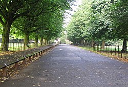
Wythenshawe Park
Wythenshawe Park is a Green Flag awarded park covering 270 acres. The park features woodland, bedding, grassland and meadows, sporting facilities, a community farm and a horticulture centre.

Northern Moor
Northern Moor is west of Northenden and east of Sale, 5 miles south of Manchester city centre. The Tatton family lived at from 1540 to 1926 Wythenshawe Hall, which is in Northern Moor. Until the early 1900s Northern Moor was part of Cheshire, before Manchester expanded south of the River Mersey.

Wythenshawe Town F.C.
Wythenshawe Town Football Club is a football club based in Manchester. They are currently members of the North West Counties League Premier Division and play at Ericstan Stadium.

Brooklands (Manchester ward)
Brooklands is an area and electoral ward of Manchester. It is represented in Westminster by Mike Kane, MP for Wythenshawe and Sale East. The 2011 Census recorded a population of 14,362.
Didsbury East (ward)
Didsbury East is an area and electoral ward of Manchester. It is represented in Westminster by Jeff Smith MP for Manchester Withington. The 2011 Census recorded a population of 14,333.

St Paul’s Methodist Church, Didsbury
St Paul’s Methodist Church is a former Methodist church in Didsbury, Manchester. The building was designed by the architect H.H. Vale as a church for the nearby Wesleyan Theological Institution and opened in 1877. It is recorded in the National Heritage List as a designated Grade II listed building.

Didsbury West (ward)
Didsbury West is a suburb and electoral ward of Manchester. It is represented in Westminster by Jeff Smith MP for Manchester Withington. The 2011 Census recorded a population of 12,455.
![]()
Fletcher Moss Rangers F.C.
Fletcher Moss Rangers Football Club is an amateur junior football club based in Didsbury, Manchester. The club was established in 1986, with Wes Brown, Jesse Lingard, Marcus Rashford, and Danny Welbeck, who previously played for the club, going onto sign professional contracts with Manchester United and also represented the English national team. The boys and girls in the club come from extremely deprived homes.

The Towers (Manchester)
Shirley Institute was established in 1920 at a cost of £10,000 to accommodate the newly formed British Cotton Industry Research Association. It is a Grade II* listed building in the suburb of Didsbury, located 6 miles (10 km) south of the centre of Manchester.
Visit Wythenshawe plaques
 8
8
plaques
here Wythenshawe has 8 physical plaques in tourist plaque schemes for you to explore via Walkfo Wythenshawe plaques audio map when visiting. Plaques like National Heritage’s “Blue Plaques” provide visual geo-markers to highlight points-of-interest at the places where they happened – and Walkfo’s AI has researched additional, deeper content when you visit Wythenshawe using the app. Experience the history of a location when Walkfo local tourist guide app triggers audio close to each Wythenshawe plaque. Explore Plaques & History has a complete list of Hartlepool’s plaques & Hartlepool history plaque map.


 Trying to encourage visitors to Wythenshawe?