Welcome to Visit Wylde Green Places
The Walkfo guide to things to do & explore in Wylde Green
 Visit Wylde Green places using Walkfo for free guided tours of the best Wylde Green places to visit. A unique way to experience Wylde Green’s places, Walkfo allows you to explore Wylde Green as you would a museum or art gallery with audio guides.
Visiting Wylde Green Walkfo Preview
When you visit Wylde Green, Walkfo brings Wylde Green places to life as you travel by foot, bike, bus or car with a mobile phone & headphones.
Wylde Green Places Overview: History, Culture & Facts about Wylde Green
Visit Wylde Green – Walkfo’s stats for the places to visit
With 86 audio plaques & Wylde Green places for you to explore in the Wylde Green area, Walkfo is the world’s largest heritage & history digital plaque provider. The AI continually learns & refines facts about the best Wylde Green places to visit from travel & tourism authorities (like Wikipedia), converting history into an interactive audio experience.
Wylde Green history
In the 16th century, Wylde Green was sparsely populated. After the Enclosure Act of 1825, there was some development and in 1840 the growth of the population to about 60 led to the building of the first school. In the 1850s substantial Victorian mansions began to appear along the Birmingham Road. Highbridge Road and Station Road were laid out in 1858 in anticipation of the coming of the railway.
Wylde Green geography / climate
Wylde Green is situated on the south side of Sutton Coldfield, bordering the Chester Road district of north Erdington, Birmingham and the Pype Hayes district to the southeast. To the north is Beeches Walk (an informal boundary between it and the Maney area that heralds the start of the town centre) To the east across New Hall Valley is Walmley, and on the west is Boldmere.
Why visit Wylde Green with Walkfo Travel Guide App?
 You can visit Wylde Green places with Walkfo Wylde Green to hear history at Wylde Green’s places whilst walking around using the free digital tour app. Walkfo Wylde Green has 86 places to visit in our interactive Wylde Green map, with amazing history, culture & travel facts you can explore the same way you would at a museum or art gallery with information audio headset. With Walkfo, you can travel by foot, bike or bus throughout Wylde Green, being in the moment, without digital distraction or limits to a specific walking route. Our historic audio walks, National Trust interactive audio experiences, digital tour guides for English Heritage locations are available at Wylde Green places, with a AI tour guide to help you get the best from a visit to Wylde Green & the surrounding areas.
“Curated content for millions of locations across the UK, with 86 audio facts unique to Wylde Green places in an interactive Wylde Green map you can explore.”
Walkfo: Visit Wylde Green Places Map
86 tourist, history, culture & geography spots
Wylde Green historic spots | Wylde Green tourist destinations | Wylde Green plaques | Wylde Green geographic features |
| Walkfo Wylde Green tourism map key: places to see & visit like National Trust sites, Blue Plaques, English Heritage locations & top tourist destinations in Wylde Green | |||
Best Wylde Green places to visit
Wylde Green has places to explore by foot, bike or bus. Below are a selection of the varied Wylde Green’s destinations you can visit with additional content available at the Walkfo Wylde Green’s information audio spots:
 | Gravelly Hill Gravelly Hill is an area of Birmingham, United Kingdom . It is a small part of the Birmingham city centre of the city . It was also known as Gravelly Hills in the 1960s . |
 | Short Heath, Birmingham Short Heath is an area of Birmingham, England near to Erdington . The area’s postcode is B23. The area is near Erdington and Short Heath . |
 | Perry Common Perry Common is an area of north Birmingham that includes parts of Stockland Green and Kingstanding . It falls within the Birmingham Erdington parliamentary constituency . |
 | Fort Dunlop Fort Dunlop (grid reference SP129902), is the name of the original tyre factory . It was established in 1917, and by 1954 the entire factory area employed 10,000 workers . At one time it was the world’s largest factory . |
 | Castle Vale Town F.C. Castle Vale Town Football Club is a football club based in the Castle Vale area of Birmingham, England . They are currently members of the Midland League Division Three and play at the Vale Stadium . |
| OpenStreetMap Foundation The OpenStreetMap Foundation (abbreviated OSMF) is a non-profit foundation whose aim is to support and enable the development of freely-reusable geospatial data. Its constitution does not prevent it supporting other projects. |
 | Romulus F.C. Romulus Football Club is a football club based in Castle Vale, Birmingham, England. The club was formed in 1979 by club president Roger Evans, initially the team played Sunday league football. First team play in the Midland League Premier Division. |
 | Sutton Trinity (ward) Sutton Trinity is one of the 40 electoral wards in Birmingham. It is named after Holy Trinity Church, the town’s parish church. It was created on 10 June 2004 following a Boundary Commission review of the city. |
 | Sutton Coldfield power station Sutton Coldfield power station supplied electricity to the town from 1901 to 1959. It was closed in 1959 when it had a generating capacity of 1.0 MW. |
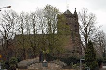 | Holy Trinity Church, Sutton Coldfield Holy Trinity Parish Church is the parish church of Sutton Coldfield, Birmingham. It is Grade I listed and gives its name to the ward in which it stands, Sutton Trinity. |
Visit Wylde Green plaques
 14
14
plaques
here Wylde Green has 14 physical plaques in tourist plaque schemes for you to explore via Walkfo Wylde Green plaques audio map when visiting. Plaques like National Heritage’s “Blue Plaques” provide visual geo-markers to highlight points-of-interest at the places where they happened – and Walkfo’s AI has researched additional, deeper content when you visit Wylde Green using the app. Experience the history of a location when Walkfo local tourist guide app triggers audio close to each Wylde Green plaque. Explore Plaques & History has a complete list of Hartlepool’s plaques & Hartlepool history plaque map.


 Trying to encourage visitors to Wylde Green?