Welcome to Visit Wrington Places
The Walkfo guide to things to do & explore in Wrington
 Visit Wrington places using Walkfo for free guided tours of the best Wrington places to visit. A unique way to experience Wrington’s places, Walkfo allows you to explore Wrington as you would a museum or art gallery with audio guides.
Visiting Wrington Walkfo Preview
Wrington lies in the valley of the Congresbury Yeo river, about 9 miles (14 km) east of Weston-super-Mare. Its population of 2,633 at the 2011 Census was estimated in 2019 to be 2,759. When you visit Wrington, Walkfo brings Wrington places to life as you travel by foot, bike, bus or car with a mobile phone & headphones.
Wrington Places Overview: History, Culture & Facts about Wrington
Visit Wrington – Walkfo’s stats for the places to visit
With 25 audio plaques & Wrington places for you to explore in the Wrington area, Walkfo is the world’s largest heritage & history digital plaque provider. The AI continually learns & refines facts about the best Wrington places to visit from travel & tourism authorities (like Wikipedia), converting history into an interactive audio experience.
Wrington history
Wrington Cottage Hospital opened in 1864, initially for 24 patients. The first surgeon was Horace Swete, author of the Handy Book of Cottage Hospitals. Wrington had a railway station between 1901 and 1963.
Why visit Wrington with Walkfo Travel Guide App?
 You can visit Wrington places with Walkfo Wrington to hear history at Wrington’s places whilst walking around using the free digital tour app. Walkfo Wrington has 25 places to visit in our interactive Wrington map, with amazing history, culture & travel facts you can explore the same way you would at a museum or art gallery with information audio headset. With Walkfo, you can travel by foot, bike or bus throughout Wrington, being in the moment, without digital distraction or limits to a specific walking route. Our historic audio walks, National Trust interactive audio experiences, digital tour guides for English Heritage locations are available at Wrington places, with a AI tour guide to help you get the best from a visit to Wrington & the surrounding areas.
“Curated content for millions of locations across the UK, with 25 audio facts unique to Wrington places in an interactive Wrington map you can explore.”
Walkfo: Visit Wrington Places Map
25 tourist, history, culture & geography spots
Wrington historic spots | Wrington tourist destinations | Wrington plaques | Wrington geographic features |
| Walkfo Wrington tourism map key: places to see & visit like National Trust sites, Blue Plaques, English Heritage locations & top tourist destinations in Wrington | |||
Best Wrington places to visit
Wrington has places to explore by foot, bike or bus. Below are a selection of the varied Wrington’s destinations you can visit with additional content available at the Walkfo Wrington’s information audio spots:
 | Meat Research Institute Meat Research Institute was a research institute in North Somerset. It was founded in 1967 to provide research for the British meat industry. Founded in 1967. |
 | Church of All Saints, Wrington The Church of All Saints is the Church of England parish church for the village of Wrington, Somerset. There has been a church here since the 13th century, though much of the present building dates from the 15th century. Historic England have designated it a Grade I listed building. |
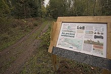 | Cleeve Toot Cleeve Toot is an Iron Age univallate hillfort above Goblin Combe, Cleeve, Somerset. It is a roughly oval settlement which is approximately 125 metres (410 ft) in length by 90 metres (300 ft) to the north. Pits have been found at the site indicating the presence of round houses. |
 | Church of Holy Trinity, Cleeve The Church Of Holy Trinity at Cleeve in Somerset was built in 1840. It is a Grade II* listed building and Grade II listed building. |
 | Urchinwood Manor Urchinwood Manor is a Grade II* listed building at Congresbury within the English county of Somerset. Part of the house was built around 1620 with additions being made in the 17th century. The house and surrounding estate has been bought and sold many times over the centuries. |
 | Goblin Combe Goblin Combe stretches for approximately 3½ km from Redhill, near Bristol International Airport, through to Cleeve on the A370. Above the valley is Cleeve Toot an Iron Age hillfort, a roughly oval settlement which is approximately 125 metres (410 ft) in length by 90 metres (300 ft) to the north. |
Visit Wrington plaques
 0
0
plaques
here Wrington has 0 physical plaques in tourist plaque schemes for you to explore via Walkfo Wrington plaques audio map when visiting. Plaques like National Heritage’s “Blue Plaques” provide visual geo-markers to highlight points-of-interest at the places where they happened – and Walkfo’s AI has researched additional, deeper content when you visit Wrington using the app. Experience the history of a location when Walkfo local tourist guide app triggers audio close to each Wrington plaque. Currently No Physical Plaques.


 Trying to encourage visitors to Wrington?