Welcome to Visit Woldingham Places
The Walkfo guide to things to do & explore in Woldingham
 Visit Woldingham places using Walkfo for free guided tours of the best Woldingham places to visit. A unique way to experience Woldingham’s places, Walkfo allows you to explore Woldingham as you would a museum or art gallery with audio guides.
Visiting Woldingham Walkfo Preview
When you visit Woldingham, Walkfo brings Woldingham places to life as you travel by foot, bike, bus or car with a mobile phone & headphones.
Woldingham Places Overview: History, Culture & Facts about Woldingham
Visit Woldingham – Walkfo’s stats for the places to visit
With 27 audio plaques & Woldingham places for you to explore in the Woldingham area, Walkfo is the world’s largest heritage & history digital plaque provider. The AI continually learns & refines facts about the best Woldingham places to visit from travel & tourism authorities (like Wikipedia), converting history into an interactive audio experience.
Woldingham history
Early history
Two bronze fibulae, some stone arrow-heads and celts were found here about 1800 . The remains are thought to date back to 1800 .
Dark and Middle Ages

The place-name ‘Woldingham’ is first attested in the Domesday Book of 1086 . The name means “the village or homestead of the people of the Weald or wood”
Upper Court Manor
Upper Court Manor was owned by a series of high-profile nobles indicating its wealth . Edward, Duke of Buckingham, who was attainted and beheaded in 1521 left it for Henry VIII to grant .
Nether Court Manor
Less notable nobles followed generally except for Sir Guy Ferre’s wife, Sir Thomas Uvedale and great-grandson of the same name and rank (not inherited) Edward Duke of Buckingham and John Gresham of London .
Marden Park Manor

Marden Park, formerly a manor, owned much of the area, however it was until some point after 1911 part of the parish of Godstone . The inhabitants of Marden and Lagham were nearly exterminated by the Black Death of 1349 .
Post-Industrial Revolution

The railway or Croydon and East Grinstead line was opened in 1884 including a station then named Marden Park . A tunnel was built to take the line under the high wolds that make up most of the village .
Woldingham geography / climate

Woldingham is 17.5 miles (28.2 km) south-by-southeast of London. Situated high on the North Downs in its Area of Outstanding Natural Beauty between Oxted and Warlingham.
Why visit Woldingham with Walkfo Travel Guide App?
 You can visit Woldingham places with Walkfo Woldingham to hear history at Woldingham’s places whilst walking around using the free digital tour app. Walkfo Woldingham has 27 places to visit in our interactive Woldingham map, with amazing history, culture & travel facts you can explore the same way you would at a museum or art gallery with information audio headset. With Walkfo, you can travel by foot, bike or bus throughout Woldingham, being in the moment, without digital distraction or limits to a specific walking route. Our historic audio walks, National Trust interactive audio experiences, digital tour guides for English Heritage locations are available at Woldingham places, with a AI tour guide to help you get the best from a visit to Woldingham & the surrounding areas.
“Curated content for millions of locations across the UK, with 27 audio facts unique to Woldingham places in an interactive Woldingham map you can explore.”
Walkfo: Visit Woldingham Places Map
27 tourist, history, culture & geography spots
Woldingham historic spots | Woldingham tourist destinations | Woldingham plaques | Woldingham geographic features |
| Walkfo Woldingham tourism map key: places to see & visit like National Trust sites, Blue Plaques, English Heritage locations & top tourist destinations in Woldingham | |||
Best Woldingham places to visit
Woldingham has places to explore by foot, bike or bus. Below are a selection of the varied Woldingham’s destinations you can visit with additional content available at the Walkfo Woldingham’s information audio spots:
 | Caterham and Warlingham Urban District Caterham and Warlingham was an Urban District of Surrey in England until 1974 . It was the first Urban District to be named after Caterham in Surrey . |
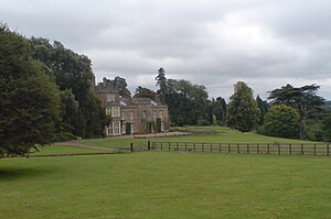 | Titsey Place Titsey Place was built by Sir John Gresham (1495–1556) on the site of a earlier dwelling. The mostly Tudor house was demolished and rebuilt in the 18th century, before being refronted in 1826. Finally a tower was added in 1856. |
 | Tatsfield Receiving Station The Tatsfield Receiving Station was a radio broadcasting signals-receiving and frequency-measuring facility operated by the British Broadcasting Corporation. The station was in operation between 1929 and 1974. |
Visit Woldingham plaques
 3
3
plaques
here Woldingham has 3 physical plaques in tourist plaque schemes for you to explore via Walkfo Woldingham plaques audio map when visiting. Plaques like National Heritage’s “Blue Plaques” provide visual geo-markers to highlight points-of-interest at the places where they happened – and Walkfo’s AI has researched additional, deeper content when you visit Woldingham using the app. Experience the history of a location when Walkfo local tourist guide app triggers audio close to each Woldingham plaque. Explore Plaques & History has a complete list of Hartlepool’s plaques & Hartlepool history plaque map.


 Trying to encourage visitors to Woldingham?