Welcome to Visit Whitehill, Staffordshire Places
The Walkfo guide to things to do & explore in Whitehill, Staffordshire
 Visit Whitehill, Staffordshire places using Walkfo for free guided tours of the best Whitehill, Staffordshire places to visit. A unique way to experience Whitehill, Staffordshire’s places, Walkfo allows you to explore Whitehill, Staffordshire as you would a museum or art gallery with audio guides.
Visiting Whitehill, Staffordshire Walkfo Preview
Whitehill, Staffordshire is a village North-East of Kidsgrove. Often, it is called a part of the town, however the boundaries for the town and the village can be seen upon Atwood Street, near Dove Bank Primary School. When you visit Whitehill, Staffordshire, Walkfo brings Whitehill, Staffordshire places to life as you travel by foot, bike, bus or car with a mobile phone & headphones.
Whitehill, Staffordshire Places Overview: History, Culture & Facts about Whitehill, Staffordshire
Visit Whitehill, Staffordshire – Walkfo’s stats for the places to visit
With 43 audio plaques & Whitehill, Staffordshire places for you to explore in the Whitehill, Staffordshire area, Walkfo is the world’s largest heritage & history digital plaque provider. The AI continually learns & refines facts about the best Whitehill, Staffordshire places to visit from travel & tourism authorities (like Wikipedia), converting history into an interactive audio experience.
Whitehill, Staffordshire landmarks
Whitehill is home to Maryhill High School and Maryhill Primary School, as well as GP Doctor’s Surgery and a Pharmacy, Birchenwood Park, a Co-Operative convenience store, a Hairdresser’s and a portion of the First Potteries Bus Route 7/7C.
Whitehill, Staffordshire geography / climate
Whitehill is just south of The Rookery, a small village south-west of Mow Cop. It is North-East of Kidsgrove, and spans approximately 2500 square feet.
Why visit Whitehill, Staffordshire with Walkfo Travel Guide App?
 You can visit Whitehill, Staffordshire places with Walkfo Whitehill, Staffordshire to hear history at Whitehill, Staffordshire’s places whilst walking around using the free digital tour app. Walkfo Whitehill, Staffordshire has 43 places to visit in our interactive Whitehill, Staffordshire map, with amazing history, culture & travel facts you can explore the same way you would at a museum or art gallery with information audio headset. With Walkfo, you can travel by foot, bike or bus throughout Whitehill, Staffordshire, being in the moment, without digital distraction or limits to a specific walking route. Our historic audio walks, National Trust interactive audio experiences, digital tour guides for English Heritage locations are available at Whitehill, Staffordshire places, with a AI tour guide to help you get the best from a visit to Whitehill, Staffordshire & the surrounding areas.
“Curated content for millions of locations across the UK, with 43 audio facts unique to Whitehill, Staffordshire places in an interactive Whitehill, Staffordshire map you can explore.”
Walkfo: Visit Whitehill, Staffordshire Places Map
43 tourist, history, culture & geography spots
Whitehill, Staffordshire historic spots | Whitehill, Staffordshire tourist destinations | Whitehill, Staffordshire plaques | Whitehill, Staffordshire geographic features |
| Walkfo Whitehill, Staffordshire tourism map key: places to see & visit like National Trust sites, Blue Plaques, English Heritage locations & top tourist destinations in Whitehill, Staffordshire | |||
Best Whitehill, Staffordshire places to visit
Whitehill, Staffordshire has places to explore by foot, bike or bus. Below are a selection of the varied Whitehill, Staffordshire’s destinations you can visit with additional content available at the Walkfo Whitehill, Staffordshire’s information audio spots:
 | Golden Torch The Golden Torch, more commonly known as The Torch, was a nightclub in Tunstall, Stoke-on-Trent, England. Opened as a mod venue, it later became important to fans of Northern soul. Peter Stringfellow was among the many DJs who had a residency there. |
 | Christ Church, Tunstall Christ Church is an Anglican church in Tunstall, Stoke-on-Trent, Staffordshire. It is the parish church of Goldenhill and Tunstall; the combined parish, which is an Anglo-Catholic parish, was created in 2010. The church is a Grade II listed building. |
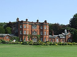
 | Lawton Hall Lawton Hall is a former country house to the east of the village of Church Lawton, Cheshire. The building has since been used as a hotel, then a school, and has been converted into separate residential units. It is recorded in the National Heritage List for England as a Grade II listed building. |
 | Mow Cop Castle Mow Cop Castle is a folly in Odd Rode, Cheshire, England. It is recorded in the National Heritage List for England as a Grade II listed building. The ridge upon which the castle sits forms the boundary between the counties of Cheshire and Staffordshire. |
 | Ramsdell Hall Ramsdell Hall is a country house in the parish of Odd Rode in Cheshire, England, overlooking the Macclesfield Canal. It was built in two phases during the 18th century and is still in private ownership. |
Visit Whitehill, Staffordshire plaques
 2
2
plaques
here Whitehill, Staffordshire has 2 physical plaques in tourist plaque schemes for you to explore via Walkfo Whitehill, Staffordshire plaques audio map when visiting. Plaques like National Heritage’s “Blue Plaques” provide visual geo-markers to highlight points-of-interest at the places where they happened – and Walkfo’s AI has researched additional, deeper content when you visit Whitehill, Staffordshire using the app. Experience the history of a location when Walkfo local tourist guide app triggers audio close to each Whitehill, Staffordshire plaque. Explore Plaques & History has a complete list of Hartlepool’s plaques & Hartlepool history plaque map.


 Trying to encourage visitors to Whitehill, Staffordshire?