Welcome to Visit Whitehill, Midlothian Places
The Walkfo guide to things to do & explore in Whitehill, Midlothian
 Visit Whitehill, Midlothian places using Walkfo for free guided tours of the best Whitehill, Midlothian places to visit. A unique way to experience Whitehill, Midlothian’s places, Walkfo allows you to explore Whitehill, Midlothian as you would a museum or art gallery with audio guides.
Visiting Whitehill, Midlothian Walkfo Preview
Whitehill is situated 1.5 miles (2 km) south-east of Dalkeith. It is situated on the northwest slope of the Mayfield-Tranent ridge which spans the border between Midlothian and East Lothian. Both road entrances to the village offer magnificent panoramic views over Edinburgh and the Pentland Hills. When you visit Whitehill, Midlothian, Walkfo brings Whitehill, Midlothian places to life as you travel by foot, bike, bus or car with a mobile phone & headphones.
Whitehill, Midlothian Places Overview: History, Culture & Facts about Whitehill, Midlothian
Visit Whitehill, Midlothian – Walkfo’s stats for the places to visit
With 28 audio plaques & Whitehill, Midlothian places for you to explore in the Whitehill, Midlothian area, Walkfo is the world’s largest heritage & history digital plaque provider. The AI continually learns & refines facts about the best Whitehill, Midlothian places to visit from travel & tourism authorities (like Wikipedia), converting history into an interactive audio experience.
Whitehill, Midlothian history
Whitehill is located on Dere Street, an ancient Roman road that linked the fort at Cramond to York. Map records from 1821 show that the village grew from individual houses/buildings at Wet Holm and Whitehill. Farming and mining increased the population of the village during the agricultural and industrial revolutions.
Whitehill, Midlothian etymology
The name of the village comes from the name of a farmstead situated near to the entrance/exit of village towards Edgehead. The name may have been derived from the definition of unploughed arable farmland as being ‘white’ The village is at higher elevation than the Esk valley and could also be the origin of the name.
Why visit Whitehill, Midlothian with Walkfo Travel Guide App?
 You can visit Whitehill, Midlothian places with Walkfo Whitehill, Midlothian to hear history at Whitehill, Midlothian’s places whilst walking around using the free digital tour app. Walkfo Whitehill, Midlothian has 28 places to visit in our interactive Whitehill, Midlothian map, with amazing history, culture & travel facts you can explore the same way you would at a museum or art gallery with information audio headset. With Walkfo, you can travel by foot, bike or bus throughout Whitehill, Midlothian, being in the moment, without digital distraction or limits to a specific walking route. Our historic audio walks, National Trust interactive audio experiences, digital tour guides for English Heritage locations are available at Whitehill, Midlothian places, with a AI tour guide to help you get the best from a visit to Whitehill, Midlothian & the surrounding areas.
“Curated content for millions of locations across the UK, with 28 audio facts unique to Whitehill, Midlothian places in an interactive Whitehill, Midlothian map you can explore.”
Walkfo: Visit Whitehill, Midlothian Places Map
28 tourist, history, culture & geography spots
Whitehill, Midlothian historic spots | Whitehill, Midlothian tourist destinations | Whitehill, Midlothian plaques | Whitehill, Midlothian geographic features |
| Walkfo Whitehill, Midlothian tourism map key: places to see & visit like National Trust sites, Blue Plaques, English Heritage locations & top tourist destinations in Whitehill, Midlothian | |||
Best Whitehill, Midlothian places to visit
Whitehill, Midlothian has places to explore by foot, bike or bus. Below are a selection of the varied Whitehill, Midlothian’s destinations you can visit with additional content available at the Walkfo Whitehill, Midlothian’s information audio spots:
 | National Mining Museum Scotland The National Mining Museum Scotland was created in 1984 to preserve the physical surface remains of Lady Victoria Colliery at Newtongrange, Midlothian, Scotland. The colliery, sunk by the Lothian Coal Company in 1890, came into production in 1894. It was nationalised in 1947 and closed in 1981. |
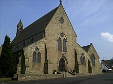 | St David’s Church, Dalkeith St David’s Church was founded in 1854 by Cecil Chetwynd Kerr, Marchioness of Lothian. It was designed by Joseph Hansom and is a category A listed building. |
 | Carberry Tower Carberry Tower is a historic house in East Lothian, Scotland. The house is situated off the A6124 road, 2 miles (3.2 km) south-east of Musselburgh. It is protected as a Category B listed building. |
 | Cousland Cousland is a village in Midlothian, Scotland. It is located 4 kilometres (2.5 mi) east of Dalkeith and 3 kilometres (1.9 mi) west of Ormiston. |
 | Oxenfoord Castle Oxenfoord Castle is a country house in Midlothian, Scotland. Originally a 16th-century tower house, the present castle is largely the result of major rebuilding in 1782. It was the seat of the Earl of Stair from 1840, and remains in private ownership. |
Visit Whitehill, Midlothian plaques
 1
1
plaques
here Whitehill, Midlothian has 1 physical plaques in tourist plaque schemes for you to explore via Walkfo Whitehill, Midlothian plaques audio map when visiting. Plaques like National Heritage’s “Blue Plaques” provide visual geo-markers to highlight points-of-interest at the places where they happened – and Walkfo’s AI has researched additional, deeper content when you visit Whitehill, Midlothian using the app. Experience the history of a location when Walkfo local tourist guide app triggers audio close to each Whitehill, Midlothian plaque. Explore Plaques & History has a complete list of Hartlepool’s plaques & Hartlepool history plaque map.


 Trying to encourage visitors to Whitehill, Midlothian?