Welcome to Visit Whalley, Lancashire Places
The Walkfo guide to things to do & explore in Whalley, Lancashire
![]() Visit Whalley, Lancashire places using Walkfo for free guided tours of the best Whalley, Lancashire places to visit. A unique way to experience Whalley, Lancashire’s places, Walkfo allows you to explore Whalley, Lancashire as you would a museum or art gallery with audio guides.
Visit Whalley, Lancashire places using Walkfo for free guided tours of the best Whalley, Lancashire places to visit. A unique way to experience Whalley, Lancashire’s places, Walkfo allows you to explore Whalley, Lancashire as you would a museum or art gallery with audio guides.
Visiting Whalley, Lancashire Walkfo Preview
Whalley is a large village and civil parish in the Ribble Valley on the banks of the River Calder in Lancashire. The population of the civil parish was 2,645 at the census of 2001, and increased to 3,629 in 2011. When you visit Whalley, Lancashire, Walkfo brings Whalley, Lancashire places to life as you travel by foot, bike, bus or car with a mobile phone & headphones.
Whalley, Lancashire Places Overview: History, Culture & Facts about Whalley, Lancashire
Visit Whalley, Lancashire – Walkfo’s stats for the places to visit
With 35 audio plaques & Whalley, Lancashire places for you to explore in the Whalley, Lancashire area, Walkfo is the world’s largest heritage & history digital plaque provider. The AI continually learns & refines facts about the best Whalley, Lancashire places to visit from travel & tourism authorities (like Wikipedia), converting history into an interactive audio experience.
Whalley, Lancashire history
Portfield Hillfort also known as Planes Wood Camp is thought to date from late Bronze Age or Iron Age. It is located on a slight promontory overlooking the valley of the River Calder southeast of the town.
Flooding

Whalley was severely affected by flooding in December 2015. Hundreds of homes were damaged and many residents required rescue as flood water from the nearby River Calder engulfed their homes. The restoration of many homes damaged by the flood remains in progress.
Whalley, Lancashire culture & places
Whalley Pickwick Night (named after Charles Dickens novel The Pickwick Papers) is an event in December of each year with people in Victorian costume to raise funds for charity. The first event was in the 1980s as a late night (6pm–9 pm) Christmas shopping event, and in more recent years has expanded with stalls, indoor events and a religious service.
Whalley, Lancashire landmarks
Whalley Viaduct
Known locally as “Whalley Arches”, Whalley Viaduct is a 48-span railway bridge crossing the River Calder. It is a red brick arch structure and the longest and largest railway viaduct in Lancashire. It carries the railway, now known as the Ribble Valley Line, 21.3m over the river for 620m.
Whalley Abbey
Whalley Abbey is a 14th-century Cistercian abbey on the banks of the Calder. The monks described the site of their abbey beneath the river as a ‘bless place’
Other places of interest
The parish church of St Mary and All Saints dates to 628 in the period when St. Paulinus was said to have preached at Whalley. A Roman Catholic church, The English Martyrs, lies near the Abbey. Until the 1980s there was a girls’ boarding school called Whiteacre.
Calder’s waterfall and isles
The River Calder has a man made weir section which supposedly allowed the monks of Whalley Abbey to collect water easily. It has been suggested that was one of the main reasons for the abbey being built where it was. The mill has now been transformed into flats, but you can still see the remains of the wheel through an opening at the back of the building.
Why visit Whalley, Lancashire with Walkfo Travel Guide App?
![]() You can visit Whalley, Lancashire places with Walkfo Whalley, Lancashire to hear history at Whalley, Lancashire’s places whilst walking around using the free digital tour app. Walkfo Whalley, Lancashire has 35 places to visit in our interactive Whalley, Lancashire map, with amazing history, culture & travel facts you can explore the same way you would at a museum or art gallery with information audio headset. With Walkfo, you can travel by foot, bike or bus throughout Whalley, Lancashire, being in the moment, without digital distraction or limits to a specific walking route. Our historic audio walks, National Trust interactive audio experiences, digital tour guides for English Heritage locations are available at Whalley, Lancashire places, with a AI tour guide to help you get the best from a visit to Whalley, Lancashire & the surrounding areas.
You can visit Whalley, Lancashire places with Walkfo Whalley, Lancashire to hear history at Whalley, Lancashire’s places whilst walking around using the free digital tour app. Walkfo Whalley, Lancashire has 35 places to visit in our interactive Whalley, Lancashire map, with amazing history, culture & travel facts you can explore the same way you would at a museum or art gallery with information audio headset. With Walkfo, you can travel by foot, bike or bus throughout Whalley, Lancashire, being in the moment, without digital distraction or limits to a specific walking route. Our historic audio walks, National Trust interactive audio experiences, digital tour guides for English Heritage locations are available at Whalley, Lancashire places, with a AI tour guide to help you get the best from a visit to Whalley, Lancashire & the surrounding areas.
“Curated content for millions of locations across the UK, with 35 audio facts unique to Whalley, Lancashire places in an interactive Whalley, Lancashire map you can explore.”
Walkfo: Visit Whalley, Lancashire Places Map
35 tourist, history, culture & geography spots
Whalley, Lancashire historic spots | Whalley, Lancashire tourist destinations | Whalley, Lancashire plaques | Whalley, Lancashire geographic features |
| Walkfo Whalley, Lancashire tourism map key: places to see & visit like National Trust sites, Blue Plaques, English Heritage locations & top tourist destinations in Whalley, Lancashire | |||
Best Whalley, Lancashire places to visit
Whalley, Lancashire has places to explore by foot, bike or bus. Below are a selection of the varied Whalley, Lancashire’s destinations you can visit with additional content available at the Walkfo Whalley, Lancashire’s information audio spots:
 | Pendleton Brook Pendleton Brook is a small brook in Lancashire. The brook rises on Pendleton Moor and flows through the village of Pendleton. It flows south of Clitheroe before meeting the River Ribble near Siddows. |
 | Billington and Langho Billington and Langho is a civil parish in the Ribble Valley district of Lancashire. It covers the villages of Billington, Langha and the hamlets of York and Old Langhe. According to the 2001 census the parish had a population of 4,555. The United Kingdom Census 2011 grouped the parish with Dinckley (2001 pop. 83) giving a total of 5,415. |
 | New St Leonard’s Church, Langho New St Leonard’s Church is in Whalley New Road, between the villages of Langho and Billington in Lancashire, England. It is an active Anglican parish church in the archdeaconry of Blackburn and the diocese of Blackburn. |
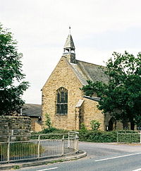
 | Church of St Mary and All Saints, Whalley The Church of St Mary and All Saints is an Anglican church in the village of Whalley, Lancashire. A church probably existed on the site in Anglo-Saxon times and the current building dates from the 13th century. It is recorded in the National Heritage List as a Grade I listed building. |
 | Calderstones Hospital Calderstones Hospital is a mental health facility near to Whalley, Lancashire. It is managed by Mersey Care NHS Foundation Trust. |
 | Old St Leonard’s Church, Langho Old St Leonard’s Church is a redundant Anglican church 1 mile (1.6 km) northwest of the village of Langho, Lancashire. It is recorded in the National Heritage List for England as a designated Grade I listed building. |
 | River Hodder The River Hodder is a County Biological Heritage Site in Lancashire. It rises on White Hill and flows for approximately 23 miles to the River Ribble. The Hodder drains much of the Forest of Bowland Area of Outstanding Natural Beauty. The upper reaches of the river feed the large Stocks Reservoir, which provides much of Lancsire’s water supply. |
 | Time and Tide Bell Time and Tide Bell is an art project made up of bells, designed by UK sculptor Marcus Vergette and Australian bell designer Neil McLachlan. The first one was placed at Appledore, Devon, in 2009 and the seventh at Mablethorpe, Lincolnshire in June 2019. |
 | Read Hall and Park Read Hall and Park is a manor house with ornamental grounds of about 450 acres (180 ha) The current hall dates from the early 19th century and is a grade II* listed building. The landscaped grounds date from around the same time and feature a waterfall, two lakes and woodland. The hall and park are not open to the public. |
Visit Whalley, Lancashire plaques
![]() 0
0
plaques
here Whalley, Lancashire has 0 physical plaques in tourist plaque schemes for you to explore via Walkfo Whalley, Lancashire plaques audio map when visiting. Plaques like National Heritage’s “Blue Plaques” provide visual geo-markers to highlight points-of-interest at the places where they happened – and Walkfo’s AI has researched additional, deeper content when you visit Whalley, Lancashire using the app. Experience the history of a location when Walkfo local tourist guide app triggers audio close to each Whalley, Lancashire plaque. Currently No Physical Plaques.