Welcome to Visit Whaley Places
The Walkfo guide to things to do & explore in Whaley
 Visit Whaley places using Walkfo for free guided tours of the best Whaley places to visit. A unique way to experience Whaley’s places, Walkfo allows you to explore Whaley as you would a museum or art gallery with audio guides.
Visiting Whaley Walkfo Preview
Whaley is a small village in Derbyshire, England, located one mile from Whaley Thorns. The village has a garage and a former watermill, now a home, of which the large mill pond still survives. A school, known as St Mary’s Mission, and school house were built in the 1860s but both these are now residential. When you visit Whaley, Walkfo brings Whaley places to life as you travel by foot, bike, bus or car with a mobile phone & headphones.
Whaley Places Overview: History, Culture & Facts about Whaley
Visit Whaley – Walkfo’s stats for the places to visit
With 28 audio plaques & Whaley places for you to explore in the Whaley area, Walkfo is the world’s largest heritage & history digital plaque provider. The AI continually learns & refines facts about the best Whaley places to visit from travel & tourism authorities (like Wikipedia), converting history into an interactive audio experience.
Whaley etymology
Whaley most likely comes from the Celtic word Whallis, meaning water. A tributary of the River Poulter runs through the village. A well, now capped, was situated near Red Brick Cottage.
Why visit Whaley with Walkfo Travel Guide App?
 You can visit Whaley places with Walkfo Whaley to hear history at Whaley’s places whilst walking around using the free digital tour app. Walkfo Whaley has 28 places to visit in our interactive Whaley map, with amazing history, culture & travel facts you can explore the same way you would at a museum or art gallery with information audio headset. With Walkfo, you can travel by foot, bike or bus throughout Whaley, being in the moment, without digital distraction or limits to a specific walking route. Our historic audio walks, National Trust interactive audio experiences, digital tour guides for English Heritage locations are available at Whaley places, with a AI tour guide to help you get the best from a visit to Whaley & the surrounding areas.
“Curated content for millions of locations across the UK, with 28 audio facts unique to Whaley places in an interactive Whaley map you can explore.”
Walkfo: Visit Whaley Places Map
28 tourist, history, culture & geography spots
Whaley historic spots | Whaley tourist destinations | Whaley plaques | Whaley geographic features |
| Walkfo Whaley tourism map key: places to see & visit like National Trust sites, Blue Plaques, English Heritage locations & top tourist destinations in Whaley | |||
Best Whaley places to visit
Whaley has places to explore by foot, bike or bus. Below are a selection of the varied Whaley’s destinations you can visit with additional content available at the Walkfo Whaley’s information audio spots:
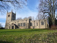
 | St Mary Magdalene’s Church, Creswell St Mary Magdalene’s Church, Creswell is a Grade II listed parish church in Derbyshire. It was built in the 1930s and is now a Grade I listed church. |
 | F.C. Bolsover Football Club Bolsover was a football club. They played at Shirebrook Town’s Langwith Road ground in Derbyshire. They were based in Bolsovers, a suburb of Bolsver, and played in the 1960s and 1970s. |
 | Shirebrook Shirebrook is a town in the Bolsover district in Derbyshire. It had a population of 13,300 in 2001, reducing to 9,760 at the 2011 Census. It is close to the boundaries with the districts of Mansfield and Bassetlaw of Nottinghamshire. |
 | St Leonard’s Church, Scarcliffe St Leonard’s Church, Scarcliffe is a Grade II* listed parish church in Scarcliffe, Derbyshire. It was built in the 1930s and is located in the area of Scarcliffe. |
 | Bolsover Hospital Bolsover Hospital was a community healthcare facility. It was managed by Derbyshire Community Health Services NHS Foundation Trust. It is now owned by a local health trust. |
 | Creswell Crags Creswell Crags is an enclosed limestone gorge on the border between Derbyshire and Nottinghamshire. Its caves contain the northernmost cave art in Europe. The caves were occupied during the last ice age, between 43,000 and 10,000 years ago. |
 | St Winifred’s Church, Holbeck St Winifred’s Chapel, Holbeck is a Grade II listed parish church and former private chapel in Holbeck, Nottinghamshire. It was built for the Dukes of Portland at Welbeck Abbey. |
 | Bolsover District At the 2011 Census, the district had a population of 75,866. It is named after the town of Bolsover, but the council is based in Clowne, Derbyshire. |
Visit Whaley plaques
 0
0
plaques
here Whaley has 0 physical plaques in tourist plaque schemes for you to explore via Walkfo Whaley plaques audio map when visiting. Plaques like National Heritage’s “Blue Plaques” provide visual geo-markers to highlight points-of-interest at the places where they happened – and Walkfo’s AI has researched additional, deeper content when you visit Whaley using the app. Experience the history of a location when Walkfo local tourist guide app triggers audio close to each Whaley plaque. Currently No Physical Plaques.


 Trying to encourage visitors to Whaley?