Welcome to Visit West Sussex Places
The Walkfo guide to things to do & explore in West Sussex
 Visit West Sussex places using Walkfo for free guided tours of the best West Sussex places to visit. A unique way to experience West Sussex’s places, Walkfo allows you to explore West Sussex as you would a museum or art gallery with audio guides.
Visiting West Sussex Walkfo Preview
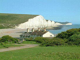
West Sussex is a county in South East England on the English Channel coast . The ceremonial county comprises the shire districts of Adur, Arun, Chichester, Horsham, and Mid Sussex . West Sussex borders Hampshire to the west, Surrey to the north, and East Sussex to the east . The highest point of the county is Blackdown, at 280 metres (919 ft) West Sussex recorded a population of 806,900 in 2011 . When you visit West Sussex, Walkfo brings West Sussex places to life as you travel by foot, bike, bus or car with a mobile phone & headphones.
West Sussex Places Overview: History, Culture & Facts about West Sussex
Visit West Sussex – Walkfo’s stats for the places to visit
With 34 audio plaques & West Sussex places for you to explore in the West Sussex area, Walkfo is the world’s largest heritage & history digital plaque provider. The AI continually learns & refines facts about the best West Sussex places to visit from travel & tourism authorities (like Wikipedia), converting history into an interactive audio experience.
West Sussex history
The oldest hominin remains known in Britain were found at Eartham Pit, Boxgrove. Prehistoric monuments include the Devil’s Jumps, a group of Bronze Age burial mounds, and the Iron Age Cissbury Ring and Chanctonbury Ring hill forts on the South Downs. The name Sussex, derived from the Old English ‘Sūþsēaxe’ (‘South Saxons’) dates from the Saxon period between AD 477 to 1066.
Provision for paupers
Until 1834 provision for the poor and destitute in West Sussex was made at parish level . From 1835 until 1948 eleven Poor Law Unions took on the job .
West Sussex geography / climate
Physical geography

West Sussex is bordered by Hampshire to the west, Surrey to the north and East Sussex to the east . The county makes up 1.52% of the total land of England, making it the 30th largest county in the country .
Climate
West Sussex is the sunniest county in the UK, according to Met Office records . Over the last 29 years it has averaged 1902 hours of sunshine per year . Sunshine totals are highest near the coast with Bognor Regis often having the highest in mainland England .
Why visit West Sussex with Walkfo Travel Guide App?
 You can visit West Sussex places with Walkfo West Sussex to hear history at West Sussex’s places whilst walking around using the free digital tour app. Walkfo West Sussex has 34 places to visit in our interactive West Sussex map, with amazing history, culture & travel facts you can explore the same way you would at a museum or art gallery with information audio headset. With Walkfo, you can travel by foot, bike or bus throughout West Sussex, being in the moment, without digital distraction or limits to a specific walking route. Our historic audio walks, National Trust interactive audio experiences, digital tour guides for English Heritage locations are available at West Sussex places, with a AI tour guide to help you get the best from a visit to West Sussex & the surrounding areas.
“Curated content for millions of locations across the UK, with 34 audio facts unique to West Sussex places in an interactive West Sussex map you can explore.”
Walkfo: Visit West Sussex Places Map
34 tourist, history, culture & geography spots
West Sussex historic spots | West Sussex tourist destinations | West Sussex plaques | West Sussex geographic features |
| Walkfo West Sussex tourism map key: places to see & visit like National Trust sites, Blue Plaques, English Heritage locations & top tourist destinations in West Sussex | |||
Best West Sussex places to visit
West Sussex has places to explore by foot, bike or bus. Below are a selection of the varied West Sussex’s destinations you can visit with additional content available at the Walkfo West Sussex’s information audio spots:
| Storrington F.C. Storrington FC were one of the founder members of the 1st ever Sussex football league. They were formed in 1882 and reformed after the war in 1919. They have been relegated to Division Three on three occasions, but have been promoted back to Division Two after a three-season spell in the lower division. |
 | Parham Park Parham Park is an Elizabethan house and estate in the civil parish of Parham, west of the village of Cootham, and between Storrington and Pulborough, West Sussex, South East England. The estate was originally owned by the Monastery of Westminster and granted to Robert Palmer by King Henry VIII in 1540. |
 | South Downs The South Downs are a range of chalk hills that extends for about 260 square miles (670 km) across the south-eastern coastal counties of England. They are characterised by rolling chalk downland with close-cropped turf and dry valleys. South Downs National Park forms a much larger area than the chalk range of the South Downs and includes large parts of the Weald. |
 | Amberley Museum Railway The Amberley Museum and Heritage Centre Railway is a 2 ft (610 mm) narrow gauge railway. It operates passenger trains at the museum using a mixture of steam, internal combustion and battery-electric locomotives. |
Visit West Sussex plaques
 2
2
plaques
here West Sussex has 2 physical plaques in tourist plaque schemes for you to explore via Walkfo West Sussex plaques audio map when visiting. Plaques like National Heritage’s “Blue Plaques” provide visual geo-markers to highlight points-of-interest at the places where they happened – and Walkfo’s AI has researched additional, deeper content when you visit West Sussex using the app. Experience the history of a location when Walkfo local tourist guide app triggers audio close to each West Sussex plaque. Explore Plaques & History has a complete list of Hartlepool’s plaques & Hartlepool history plaque map.


 Trying to encourage visitors to West Sussex?