Welcome to Visit West Midlands (county) Places
The Walkfo guide to things to do & explore in West Midlands (county)
 Visit West Midlands (county) places using Walkfo for free guided tours of the best West Midlands (county) places to visit. A unique way to experience West Midlands (county)’s places, Walkfo allows you to explore West Midlands (county) as you would a museum or art gallery with audio guides.
Visiting West Midlands (county) Walkfo Preview
When you visit West Midlands (county), Walkfo brings West Midlands (county) places to life as you travel by foot, bike, bus or car with a mobile phone & headphones.
West Midlands (county) Places Overview: History, Culture & Facts about West Midlands (county)
Visit West Midlands (county) – Walkfo’s stats for the places to visit
With 131 audio plaques & West Midlands (county) places for you to explore in the West Midlands (county) area, Walkfo is the world’s largest heritage & history digital plaque provider. The AI continually learns & refines facts about the best West Midlands (county) places to visit from travel & tourism authorities (like Wikipedia), converting history into an interactive audio experience.
West Midlands (county) history
Birmingham and Wolverhampton have a tradition of industry dating back to the 16th century. Coventry was one of England’s most important cities during the Middle Ages, with its prosperity built upon wool and cloth manufacture. Birmingham was known for its manufacture of small arms and brass working. The area grew rapidly during the Industrial Revolution and by the 20th century had grown into one large conurbation.
County creation
In 1974, the Local Government Act 1972 came into effect creating the metropolitan county of West Midlands . The new area consisted of seven new metropolitan boroughs, with Aldridge-Brownhills added to Walsall; Halesowen and Stourbridge to Dudley and Sutton Coldfield to Birmingham . A new borough of Sandwell was formed by the merger of West Bromwich and Warley .
West Midlands County Council

Between 1974 and 1986, the county had a two-tier system of local government . The seven districts shared power with the West Midlands County Council . However, the Local Government Act 1985 abolished the metropolitan county councils . Most of its functions were devolved to the West Midland boroughs .
Boundary changes
In 1994, the western/southern shores of Chasewater, plus the adjacent Jeffreys Swag, were transferred from the Metropolitan Borough of Walsall to the District of Lichfield, Staffordshire . Further boundary changes came into effect in 1995, when part of the Hereford and Worcester parish of Frankley was transferred to Birmingham .
West Midlands Combined Authority
The West Midlands Combined Authority was created under the Local Democracy, Economic Development and Construction Act 2009 . The new body has powers over transport, economic development, skills and planning . A directly elected position of Mayor of the West Midlands was created in 2017 to chair the new body . The first Mayoral election was held in May 2017, and the position was won by Andy Street .
West Midlands (county) geography / climate

The West Midlands is a landlocked county that borders Warwickshire and Worcestershire. It borders the counties of Worcesterhire and Staffordshire to the north and west.
Why visit West Midlands (county) with Walkfo Travel Guide App?
 You can visit West Midlands (county) places with Walkfo West Midlands (county) to hear history at West Midlands (county)’s places whilst walking around using the free digital tour app. Walkfo West Midlands (county) has 131 places to visit in our interactive West Midlands (county) map, with amazing history, culture & travel facts you can explore the same way you would at a museum or art gallery with information audio headset. With Walkfo, you can travel by foot, bike or bus throughout West Midlands (county), being in the moment, without digital distraction or limits to a specific walking route. Our historic audio walks, National Trust interactive audio experiences, digital tour guides for English Heritage locations are available at West Midlands (county) places, with a AI tour guide to help you get the best from a visit to West Midlands (county) & the surrounding areas.
“Curated content for millions of locations across the UK, with 131 audio facts unique to West Midlands (county) places in an interactive West Midlands (county) map you can explore.”
Walkfo: Visit West Midlands (county) Places Map
131 tourist, history, culture & geography spots
West Midlands (county) historic spots | West Midlands (county) tourist destinations | West Midlands (county) plaques | West Midlands (county) geographic features |
| Walkfo West Midlands (county) tourism map key: places to see & visit like National Trust sites, Blue Plaques, English Heritage locations & top tourist destinations in West Midlands (county) | |||
Best West Midlands (county) places to visit
West Midlands (county) has places to explore by foot, bike or bus. Below are a selection of the varied West Midlands (county)’s destinations you can visit with additional content available at the Walkfo West Midlands (county)’s information audio spots:
 | Gosta Green Gosta Green lies at the edge of the city centre, 3/4 mile (1.2 km) northeast of Birmingham New Street station . |
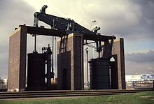 | Grazebrook beam engine The Grazebrook Engine is an 1817 beam engine that was used for blowing air over the hot coals of a blast furnace to increase the heat . It is now found as sentinel sculpture on the Dartmouth Circus roundabout in Birmingham, England . |
 | Gravelly Hill Gravelly Hill is an area of Birmingham, United Kingdom . It is a small part of the Birmingham city centre of the city . It was also known as Gravelly Hills in the 1960s . |
 | Short Heath, Birmingham Short Heath is an area of Birmingham, England near to Erdington . The area’s postcode is B23. The area is near Erdington and Short Heath . |
 | Fort Dunlop Fort Dunlop (grid reference SP129902), is the name of the original tyre factory . It was established in 1917, and by 1954 the entire factory area employed 10,000 workers . At one time it was the world’s largest factory . |
 | Ward End Ward End is an area of Birmingham, England . It covers the area between Saltley, Hodge Hill and Stechford . Includes Ward End Park, a public park that has been open for over 100 years . |
 | The Stechford Club The Stechford Club is a private members club in Birmingham . It was established in 1907 and has been members of the club since 1907 . Past members include world snooker champion Joe Davis . |
 | St Paul’s Church, Bordesley Green St Paul’s Church, Bordesley Green is a Grade A locally listed parish church in Birmingham. The Grade A Church of England parish church is located in the city centre of Birmingham. |
 | Thornton Road poltergeist Thornton Road Poltergeist refers to stone-throwing incidents in a residential area of Birmingham, England, in 1981 and the subsequent police investigation. |
 | St Benedict’s Church, Bordesley St Benedict’s Church, Bordesley is a Church of England parish church in the West Midlands. It is an early 20th-century church in Byzantine Revival style and Grade II listed. The church is about 2+1/2 miles east of Birmingham city centre. |
Visit West Midlands (county) plaques
 9
9
plaques
here West Midlands (county) has 9 physical plaques in tourist plaque schemes for you to explore via Walkfo West Midlands (county) plaques audio map when visiting. Plaques like National Heritage’s “Blue Plaques” provide visual geo-markers to highlight points-of-interest at the places where they happened – and Walkfo’s AI has researched additional, deeper content when you visit West Midlands (county) using the app. Experience the history of a location when Walkfo local tourist guide app triggers audio close to each West Midlands (county) plaque. Explore Plaques & History has a complete list of Hartlepool’s plaques & Hartlepool history plaque map.


 Trying to encourage visitors to West Midlands (county)?