Welcome to Visit West Lothian Places
The Walkfo guide to things to do & explore in West Lothian
 Visit West Lothian places using Walkfo for free guided tours of the best West Lothian places to visit. A unique way to experience West Lothian’s places, Walkfo allows you to explore West Lothian as you would a museum or art gallery with audio guides.
Visiting West Lothian Walkfo Preview
West Lothian (Scots: Wast Lowden; Scottish Gaelic: Lodainn an Iar) is one of Scotland’s 32 council areas . The county was known as Linlithgowshire and was one of its historic counties . The modern council area occupies a larger area than the historic county . When you visit West Lothian, Walkfo brings West Lothian places to life as you travel by foot, bike, bus or car with a mobile phone & headphones.
West Lothian Places Overview: History, Culture & Facts about West Lothian
Visit West Lothian – Walkfo’s stats for the places to visit
With 35 audio plaques & West Lothian places for you to explore in the West Lothian area, Walkfo is the world’s largest heritage & history digital plaque provider. The AI continually learns & refines facts about the best West Lothian places to visit from travel & tourism authorities (like Wikipedia), converting history into an interactive audio experience.
West Lothian history

Westlothiana (“animal from West Lothian”) is a genus of reptile-like tetrapod that lived about 338 million years ago during the latest part of the Visean age of the Carboniferous. Members of the genus bore a superficial resemblance to modern-day lizards. The type specimen was discovered in the East Kirkton Limestone at the East Kirkton Quarry in 1984. West Lothian was extensively settled in prehistoric times, and several ancient burial sites have been uncovered, such as at Cairnpapple Hill, described as one of Scotlands richest archaeological sites and one of the earlier places of organised worship in the country. There are remains of hillforts on Cockleroy, Peace Knowe, Bowden, Cairnpapple, and Binns Hills. The area was anciently inhabited by Britons of the tribe known as the Votadini or Gododdin. By 83 AD, southern Scotland had been conquered by Romans, who built a road from their fort at Cramond to the eastern end of the Antonine Wall, as well as forts in West Lothian (of which Castle Greg is a known example). The Romans withdrew roughly two centuries later, and the area was left to the Britons until the arrival of Anglo-Saxons in the fifth and sixth centuries, who brought Lothian under the rule of the Kingdom of Northumbria. In later centuries the region was regularly overrun by Gaelic-speaking Scots, and it became permanently part of the Kingdom of Scotland in the 11th century. Scotland was split into sheriffdoms, what would later become counties, in the reign of David I. The first known reference to a sheriff of Linlithgow occurs in a charter dating from the reign of his successor Malcolm IV. For a time West Lothian became a constabulary, but it seems to have been made a sheriffdom again during the reign of James III. During the medieval period period, settlements such as Linlithgow, Abercorn, Dalmeny and Torphichen grew in importance. Torphichen church is said to have been founded by St. Ninian in about 400AD, a small wooden structure on the site of the present church (itself rebuilt in 1756) and in 1165, the Knights Hospitaller of St. John made their Scottish headquarters at Torphichen and the Preceptory stands as testament to their presence. In pre-industrial times West Lothian was almost entirely agricultural. In the way of heavy industry there was a silver mine at Hilderston near Cairnpapple, a cotton mill at Blackburn, paper mills at Linlithgow, and shallow coal mines around Bathgate and Whitburn. The county was radically changed by the Industrial Revolution, (from about 1760 to sometime between 1820 and 1840) with the opening of deep-pit iron, coal, and shale oil mines, as well as foundries and brickworks, which dramatically altered the landscape. In Bathgate, the Scottish Chemist James Young’s discovery of cannel coal in the Boghead area of Bathgate, and his subsequent opening of the Bathgate Chemical Works in 1852 transformed the town and the adjacent landscape. The works were the world’s first commercial oil-works, manufacturing paraffin oil and paraffin wax, signalling an end to the rural community of previous centuries. When the cannel coal resources dwindled around 1866, Young and his chemical works started distilling paraffin from much more readily available shale. Shale oil extraction reached its height in the county during the Victorian era. By 1871, there were over 50 oil works producing more than 25 million gallons each year. The five largest oil shale companies (Young’s Paraffin Light & Mineral Oil Company, Broxburn Oil Company, Pumpherston Shale Oil Company, Oakbank Oil Company and James Ross & Company Philpstoun Oil Works) were concentrated in West Lothian and would later merge to become Scottish Oils Ltd. The increased industrialisation led to a growing population and the development of numerous villages, such as Pumpherston and Broxburn. The bings (black and pink hills of shale waste) produced by the mining industry, 19 of which still stand in West Lothian, were at first considered blights, but now are thought of as monuments to Scotland’s industrial past, and a representation of one appears on the council’s coat of arms. The bings are also seen as important for local and national biodiversity. The Local Government (Scotland) Act 1889 established a uniform system of county councils in Scotland and realigned the boundaries of many of Scotland’s counties. Subsequently, West Lothian County Council was created in 1890. The historic county of West Lothian or of Linlithgowshire contained six burghs: Armadale, Bathgate, Bo’ness, Linlithgow, Queensferry, and Whitburn. Areas outside the burghs were administered as districts, of which there were also six: Borrowstounness, Linlithgow, Queensferry, Torphichen & Bathgate, Uphall, and Whitburn & Livingston. The county was also split into twelve parishes; these were not used for administrative purposes after 1929. West Lothian County Council was based at the County Buildings in the High Street, Linlithgow. In 1921, the county changed its name from Linlithgowshire to West Lothian. In the Second World War the county adopted during Warship Week the destroyer HMS Wallace raising over £547,000 in donations. Many of the houses built for the expanding population during the 19th and 20th century were of poor quality, necessitating the building of thousands of council houses in the latter part of the 20th century, especially at Livingston, where several smaller settlements were historically mining villages. Under the New Towns Act of 1946, Livingston was designated as a New Town on 16 April 1962. Heavy industry in the county declined after the Second World War, and the last shale oil mine closed in 1962. In 1975, as a result of the Local Government (Scotland) Act 1973, the boundaries of West Lothian were adjusted, so that some western areas of Midlothian were added to the country, while some West Lothian settlements became part of Falkirkshire and Edinburgh. The 1973 Act abolished the counties, burghs, and districts, instead creating a system of regions and districts. West Lothian was made a district of Lothian region but lost the burgh of Bo’ness and the district of Bo’ness to Falkirk district of Central Region, the burgh of Queensferry and the district of Kirkliston and part of Winchburgh to Edinburgh district of Lothian Region. It gained East Calder and West Calder districts from Midlothian. The two-tier system was abolished by the Local Government etc. (Scotland) Act 1994, and the district of West Lothian was made into a unitary council area named West Lothian Council.
West Lothian geography / climate
The geology of West Lothian is typical for the Midland valley area geological of Scotland. The area rises from lowlands in the north to the Pentland Hills in the southeast. West Cairn Hill is the highest peak and Current County Top (CoU) at 562 m (1,844 ft)
Why visit West Lothian with Walkfo Travel Guide App?
 You can visit West Lothian places with Walkfo West Lothian to hear history at West Lothian’s places whilst walking around using the free digital tour app. Walkfo West Lothian has 35 places to visit in our interactive West Lothian map, with amazing history, culture & travel facts you can explore the same way you would at a museum or art gallery with information audio headset. With Walkfo, you can travel by foot, bike or bus throughout West Lothian, being in the moment, without digital distraction or limits to a specific walking route. Our historic audio walks, National Trust interactive audio experiences, digital tour guides for English Heritage locations are available at West Lothian places, with a AI tour guide to help you get the best from a visit to West Lothian & the surrounding areas.
“Curated content for millions of locations across the UK, with 35 audio facts unique to West Lothian places in an interactive West Lothian map you can explore.”
Walkfo: Visit West Lothian Places Map
35 tourist, history, culture & geography spots
West Lothian historic spots | West Lothian tourist destinations | West Lothian plaques | West Lothian geographic features |
| Walkfo West Lothian tourism map key: places to see & visit like National Trust sites, Blue Plaques, English Heritage locations & top tourist destinations in West Lothian | |||
Best West Lothian places to visit
West Lothian has places to explore by foot, bike or bus. Below are a selection of the varied West Lothian’s destinations you can visit with additional content available at the Walkfo West Lothian’s information audio spots:
 | Knightsridge Knightsridge (Scots: Knichtsrig) is an area of Livingston in West Lothian, Scotland. Knightsridge lies to the north of the town. |
 | Ladywell, Livingston Ladywell (Scots: Leddywall) is an area primarily residential in Livingston, West Lothian, Scotland. It is bordered to the north by Knightsridge, to the south by Howden, Howden and to the west by Eliburn. |
 | Nasmyth Bridge The Nasmyth Bridge is a Category A Listed historic bridge and local landmark in East Calder, Scotland. Located within the Almondell and Calderwood Country Park, it was designed by Scottish painter, architect, and landscape designer Alexander NasMyth. |
 | East Calder East Calder is a village located in West Lothian, Scotland, about a mile east of Mid Calder and a mile west of Wilkieston. It forms part of ‘the Calders’ (together with Mid and West Calder), three small neighbouring communities. The East Calder Gala is a local highlight held every June, dating back to 1919. |
 | River FM River FM was a radio station serving West Lothian, Scotland. It played a range of hit music and older classics. It could sometimes be picked up as far away as Kilmarnock, Dundee and Stirling. |
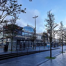 | Livingston Designer Outlet Livingston Designer Outlet is the largest outlet mall in Scotland. The glass roof reminiscent of the Crystal Palace was designed by an architect called Don Hisaka. It is currently undergoing a huge makeover in which the company has invested several million pounds. |
 | Almondell Viaduct The Almondell Viaduct is a single track viaduct spanning the gorge of the River Almond in Scotland. It is located in East Calder, West Lothian. It also spans the main canal feeder taking water from the Almond to the Union Canal. |
 | Kirk of Calder Kirk of Calder is a medieval church in Mid Calder, West Lothian. It is listed as a Category A building by Historic Environment Scotland. |
Visit West Lothian plaques
 0
0
plaques
here West Lothian has 0 physical plaques in tourist plaque schemes for you to explore via Walkfo West Lothian plaques audio map when visiting. Plaques like National Heritage’s “Blue Plaques” provide visual geo-markers to highlight points-of-interest at the places where they happened – and Walkfo’s AI has researched additional, deeper content when you visit West Lothian using the app. Experience the history of a location when Walkfo local tourist guide app triggers audio close to each West Lothian plaque. Currently No Physical Plaques.


 Trying to encourage visitors to West Lothian?