Welcome to Visit West Hackney Places
The Walkfo guide to things to do & explore in West Hackney
 Visit West Hackney places using Walkfo for free guided tours of the best West Hackney places to visit. A unique way to experience West Hackney’s places, Walkfo allows you to explore West Hackney as you would a museum or art gallery with audio guides.
Visiting West Hackney Walkfo Preview
West Hackney is a district in the London Borough of Hackney, situated on the eastern side of Ermine Street, the major Roman Road better known as the A10. Rectory Road, the principal railway station, lies 4.3 miles (6.9 km) northeast of Charing Cross. When you visit West Hackney, Walkfo brings West Hackney places to life as you travel by foot, bike, bus or car with a mobile phone & headphones.
West Hackney Places Overview: History, Culture & Facts about West Hackney
Visit West Hackney – Walkfo’s stats for the places to visit
With 443 audio plaques & West Hackney places for you to explore in the West Hackney area, Walkfo is the world’s largest heritage & history digital plaque provider. The AI continually learns & refines facts about the best West Hackney places to visit from travel & tourism authorities (like Wikipedia), converting history into an interactive audio experience.
West Hackney history
Early history
The part of Hackney included the hamlet of Newington which lay between the Roman Road (now known as the A10) and the Common. The hamlet has now been absorbed into the wider urbanised area.
Chapel of ease

The church of St. James was designed by Robert Smirke in the Greek Doric style. The 1825 creation of the ecclesiastical parish of West Hackney saw St James elevated to the status of parish church.
WWI – London’s first air raid
First bomb of the first air raid on London, a 190lb incendiary, fell on 31 May 1915. The German Army airship LZ 38 had begun the first assault on the capital by a foreign power since 1066. The householder, Albert Lovell, had just returned home from posting a letter, the bomb bounced off his chimney and went through his roof.
WWII – Blitz
West Hackney church was destroyed by enemy action in September 1940. The remains were cleared away and replaced by a modern building, rededicated to St Paul, in 1960.
Post-war
Jack ‘the Hat’ McVitie was killed at Evering Road by gangsters Ronnie and Reggie Kray. The murder was a significant factor in their downfall and imprisonment.
West Hackney geography / climate
Extent
There was formerly a West Hackney electoral ward in the Metropolitan Borough of Hackney. There is an ecclesiastical parish of West West Hackney, a sub-division of the wider Ancient Parish of Hackney. Both the ward and the ecclesiastical parody have used the A10 as the western boundary.
Open Spaces
Stoke Newington Common is the largest open space in the area at 2.15 hectares. West Hackney Recreation Ground is one hectare in extent and was originally the burial ground for St James’s church (replaced, after bombing, by St Paul’s church)
Transport
West Hackney is served by two railway stations; Rectory Road and Stoke Newington. The latter lies on the ill-defined borders of the borough.
Why visit West Hackney with Walkfo Travel Guide App?
 You can visit West Hackney places with Walkfo West Hackney to hear history at West Hackney’s places whilst walking around using the free digital tour app. Walkfo West Hackney has 443 places to visit in our interactive West Hackney map, with amazing history, culture & travel facts you can explore the same way you would at a museum or art gallery with information audio headset. With Walkfo, you can travel by foot, bike or bus throughout West Hackney, being in the moment, without digital distraction or limits to a specific walking route. Our historic audio walks, National Trust interactive audio experiences, digital tour guides for English Heritage locations are available at West Hackney places, with a AI tour guide to help you get the best from a visit to West Hackney & the surrounding areas.
“Curated content for millions of locations across the UK, with 443 audio facts unique to West Hackney places in an interactive West Hackney map you can explore.”
Walkfo: Visit West Hackney Places Map
443 tourist, history, culture & geography spots
West Hackney historic spots | West Hackney tourist destinations | West Hackney plaques | West Hackney geographic features |
| Walkfo West Hackney tourism map key: places to see & visit like National Trust sites, Blue Plaques, English Heritage locations & top tourist destinations in West Hackney | |||
Best West Hackney places to visit
West Hackney has places to explore by foot, bike or bus. Below are a selection of the varied West Hackney’s destinations you can visit with additional content available at the Walkfo West Hackney’s information audio spots:
 | Peacock Inn, Islington The Peacock Inn is a former public house at 11 Islington High Street, London, that dates from 1564 . It is located in the centre of Islington, London . |
 | White Conduit Fields White Conduit Fields in Islington was an early venue for cricket . Several major matches are known to have been played there in the 18th century . It was the original home of the White Conduits Club, forerunner of Marylebone Cricket Club (MCC) |
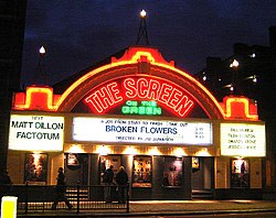 | The Screen On The Green The Screen On The Green is a single screen cinema facing Islington Green in the London Borough of Islington, London . The current building was opened in 1913 and it is one of the oldest continuously running cinemas in the UK . |
 | New North Road, Islington The New North Road is 0.8 miles (1.3 km) in length and is part of the A1200 . It is a link road from the A1 at Highbury into the City of London at Moorgate . |
 | Andover Estate Andover Estate, in Holloway, North London, is a large Islington London Borough Council housing estate . It is flanked by Hornsey Road (west), Seven Sisters Road (south), Durham Road (east) and Durham Road . It falls into the N7 postcode district of London . |
 | Manor House, London Manor House, also known as Woodberry Down, is an area of North London in the northwest corner of the London Borough of Hackney. It lies immediately east of Finsbury Park, north of Stoke Newington, west of Stamford Hill and Seven Sisters, and south of Harringay. The construction of the Seven Sisters Road gave rise to the alternative name Manor House Crossroads. |
 | Highbury New Park Highbury New Park is a street in Highbury in the London Borough of Islington . It runs from Highbury Quadrant in the north to Highbury Grove in the south . |
 | Stoke Newington Stoke Newington is part of the London Borough of Hackney. It is 5 miles (8 km) north-east of Charing Cross. The historic core of the area retains the distinct London village character. |
 | Dalston Synagogue The Dalston Synagogue was a Jewish place of worship in the London Borough of Islington, North London, from about 1885 to 1970 . Jews fleeing the pogroms of the Russian Empire established a congregation in the neighbourhood by 1876 . The Victorian Gothic building was erected in Poets Road in 1885 . |
 | Langham Working Men’s Club Langham Working Men’s Club is a traditional working men’s club in the north London neighbourhood of Harringay. It is located in north London’s north-east London neighbourhood Harringay, north London. |
Visit West Hackney plaques
 124
124
plaques
here West Hackney has 124 physical plaques in tourist plaque schemes for you to explore via Walkfo West Hackney plaques audio map when visiting. Plaques like National Heritage’s “Blue Plaques” provide visual geo-markers to highlight points-of-interest at the places where they happened – and Walkfo’s AI has researched additional, deeper content when you visit West Hackney using the app. Experience the history of a location when Walkfo local tourist guide app triggers audio close to each West Hackney plaque. Explore Plaques & History has a complete list of Hartlepool’s plaques & Hartlepool history plaque map.


 Trying to encourage visitors to West Hackney?