Welcome to Visit West Bromwich Places
The Walkfo guide to things to do & explore in West Bromwich
 Visit West Bromwich places using Walkfo for free guided tours of the best West Bromwich places to visit. A unique way to experience West Bromwich’s places, Walkfo allows you to explore West Bromwich as you would a museum or art gallery with audio guides.
Visiting West Bromwich Walkfo Preview
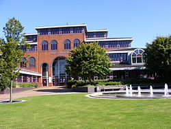
West Bromwich is a market town in the borough of Sandwell, West Midlands. It is 6.4 miles (10.3 km) northwest of Birmingham. Its growth corresponded with that of the Industrial Revolution, owing to its natural richness in ironstone and coal. The town’s primary economy developed into engineering, manufacturing, and the automotive industry through the early 20th century. When you visit West Bromwich, Walkfo brings West Bromwich places to life as you travel by foot, bike, bus or car with a mobile phone & headphones.
West Bromwich Places Overview: History, Culture & Facts about West Bromwich
Visit West Bromwich – Walkfo’s stats for the places to visit
With 91 audio plaques & West Bromwich places for you to explore in the West Bromwich area, Walkfo is the world’s largest heritage & history digital plaque provider. The AI continually learns & refines facts about the best West Bromwich places to visit from travel & tourism authorities (like Wikipedia), converting history into an interactive audio experience.
West Bromwich history
Origin and etymology
West Bromwich was first mentioned as Bromwic in the Domesday Book of 1086. A Benedictine priory existed in the 12th century around which the settlement of Broomwich Heath grew. The town became a stop on the coaching road between London and Shrewsbury in 1727.
20th century
By the outbreak of World War I in 1914, many of the older houses built to house workers during the Industrial Revolution were becoming unfit for human habitation Sanitation was inadequate, decay was rife, and the homes were becoming a danger to the health and safety of their inhabitants. After the end of the war, the local council started building new homes to rehouse people from the rundown town centre. However, there are still many late 19th century and early 20th century buildings around the centre of West Bromwich. The first Council housing in West Bromwich was built in 1920 on the Tantany Estate to the north of the town centre. Within 20 years, several thousand council houses had been built by West Bromwich County Borough Council. The largest developments were mostly in the north of the town, including the Charlemont Farm Estate around Walsall Road, and the Friar Park Estate near the border with Wednesbury. The town suffered significant damage from air raids in World War II, with 58 civilian deaths, most in the raids of 19 November 1940 around Oak Road and Lombard Street to the west of the town centre. There were a few other less severe raids during the war on parts of West Bromwich including Stone Cross and Tantany, with no fatalities. This occurred on the same night as the Birmingham Blitz, which resulted in thousands of casualties, as well as the less severe raids on nearby Dudley and Tipton. The first major postwar council housing development was the Harvills Hawthorn Estate near Hill Top, which was completed in 1948. Mass immigration from the Commonwealth took place in West Bromwich during the 1950s and 1960s, with most of these hailing from the Indian subcontinent, although a significant number of Afro-Caribbean immigrants also settled in West Bromwich. The majority of these immigrants settled in the older parts of the town that were mostly made up of Victorian and Edwardian terraced houses. The local road network was also massively improved during the 1960s and 1970s. West Bromwich is at the extreme northern end of the M5 motorway, with junction 1 serving the town on the A41 road. Traffic passing through West Bromwich on the main route from Wolverhampton to Birmingham was soon diverted along the new dual carriageway, the Northern Loop Road (also known as The Expressway), after its opening in 1972, with another dual carriageway being built to link The Expressway with neighbouring Oldbury. West Bromwich County Borough was expanded in 1966 to include the bulk of Tipton and Wednesbury, while a small part of the south-eastern section of the town was absorbed into the new Warley County Borough which was centred on neighbouring Oldbury, Smethwick and Rowley Regis. The actual town boundaries of West Bromwich were also altered at this time, placing the Friar Park estate in Wednesbury, while the Hateley Heath area of Wednesbury was now within the borders of West Bromwich township. As with many other parts of the Midlands, West Bromwich was hit badly by the recessions of the mid-1970s and early 1980s, resulting in mass unemployment across the town, exceeding 20% in some districts. Queen’s Square shopping centre opened in the town centre in 1971, providing shoppers with a 60-unit indoor shopping centre and an 850-space multi-storey car park. It cost £3million to build. The smaller King’s Square shopping centre also opened in the town in 1971. On 8 December 2011, 40 years after the opening of Queen’s Square, Sandwell Council announced that Queen’s Square would be refurbished at a cost of £5million. By this stage, the centre was falling into disrepair and only 33 of the 61 available units were occupied. Once again, West Bromwich had been hit hard by another recession, with local unemployment running high again, as well as a high vacancy rate for commercial and industrial units. Many local towns, particularly Dudley, lost many of their major stores around the time that the Merry Hill Shopping Centre which was developed at Brierley Hill during the second half of the 1980s as businesses looked to take advantage of the Enterprise Zone incentives that the centre offered. West Bromwich’s fortunes as a retail centre were affected by the Merry Hill development. This contributed to the closure of its Marks and Spencer store on 25 August 1990, along with the Dudley store, to be replaced by a new store at Merry Hill, with most of the staff at the new store being transferred from either West Bromwich or Dudley. British Home Stores also pulled out of the town around the same time, and a new store at Merry Hill which opened in November 1989 and also spelled the end of the Dudley store. The town lost another big retail name in 2005 when the Littlewoods store closed as part of the retailer’s decision to switch wholly to online shopping; the unit has since been taken over by New Look. Retail developments around Oldbury, beginning with the SavaCentre hypermarket in 1980, have also affected trade in West Bromwich. The recession beginning in 2008 has pushed the town centre further into decline, a notable casualty being the Woolworths store which closed on 30 December 2008 as a result of the retailer going into liquidation; the building was not re-occupied until Home Bargains took it over in 2012. Several more factories have closed in more recent years as manufacturers look to countries where the labour is cheaper, but West Bromwich remains a relatively busy industrial area despite the decline of the last 35 years. West Bromwich’s road links were further enhanced in 1995 on the completion of the Black Country Spine Road which also by-passes Wednesbury and the east of Bilston. The completion of this new road opened up several square miles of previously inaccessible land, and has allowed several major businesses to set up along the route. This has helped relieve some of the unemployment problems in West Bromwich, although most parts of the town still have the highest unemployment rates in the West Midlands.
21st century
West Bromwich was among the many towns and cities affected by riots in August 2011. The town has enjoyed something of an economic revival since the New Square shopping and entertainment complex opened in July 2013. The mixed success of the club has also had a significant impact on the town’s economy, particularly during the 1960s and 1970s.
West Bromwich geography / climate
Below is a list of localities: Localities. The list includes localities that have been located in the United States.
Climate
Climate in this area has mild differences between highs and lows, and there is adequate rainfall year-round. The Köppen Climate Classification subtype for this climate is “Cfb” (Marine West Coast Climate/Oceanic climate)
Why visit West Bromwich with Walkfo Travel Guide App?
 You can visit West Bromwich places with Walkfo West Bromwich to hear history at West Bromwich’s places whilst walking around using the free digital tour app. Walkfo West Bromwich has 91 places to visit in our interactive West Bromwich map, with amazing history, culture & travel facts you can explore the same way you would at a museum or art gallery with information audio headset. With Walkfo, you can travel by foot, bike or bus throughout West Bromwich, being in the moment, without digital distraction or limits to a specific walking route. Our historic audio walks, National Trust interactive audio experiences, digital tour guides for English Heritage locations are available at West Bromwich places, with a AI tour guide to help you get the best from a visit to West Bromwich & the surrounding areas.
“Curated content for millions of locations across the UK, with 91 audio facts unique to West Bromwich places in an interactive West Bromwich map you can explore.”
Walkfo: Visit West Bromwich Places Map
91 tourist, history, culture & geography spots
West Bromwich historic spots | West Bromwich tourist destinations | West Bromwich plaques | West Bromwich geographic features |
| Walkfo West Bromwich tourism map key: places to see & visit like National Trust sites, Blue Plaques, English Heritage locations & top tourist destinations in West Bromwich | |||
Best West Bromwich places to visit
West Bromwich has places to explore by foot, bike or bus. Below are a selection of the varied West Bromwich’s destinations you can visit with additional content available at the Walkfo West Bromwich’s information audio spots:
 | Charlemont and Grove Vale Charlemont with Grove Vale is a political ward in the Metropolitan Borough of Sandwell, in the English Midlands constituency of West Bromwich East . The ward population as taken at the 2011 census was 11,964 . |
 | Sandwell Sandwell is a metropolitan borough of the West Midlands county in England . The borough is named after the Sandwell Priory and spans a densely populated part of the Midlands conurbation . At the 2011 census, the borough had a population of 309,000 and an area of 86 square kilometres (33 sq mi) In 2019 Sandwell was ranked 12th most deprived of England’s 317 boroughs . |
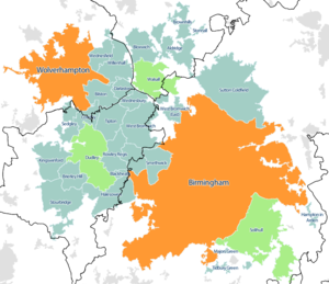 | West Midlands conurbation The West Midlands conurbation includes the cities of Birmingham and Wolverhampton and the towns of Sutton Coldfield, Dudley, Walsall, West Bromwich, Solihull, Stourbridge and Halesowen. According to the 2011 Census the area had a population of 2,440,986, making it the third most populated in the United Kingdom behind the Greater London and Greater Manchester Built Up Areas. Not to be confused with the region or metropolitan county of the same name. |
 | Portway Hill Portway Hill is part of the Rowley Hills, near Rowley Regis in West Midlands. It is the site of a nature reserve of the Wildlife Trust for Birmingham and the Black Country. |
 | Swan Village Gas Works Swan Village Gas Works, is a historical manufacturing plant in the United Kingdom for the production of coal gas. The works are situated in Swan Village, a part of West Bromwich in the metropolitan borough of Sandwell. Parts of the works are still in operation today as part of the National Grid. |
 | Sheepwash Urban Park Sheepwash Urban Park is a Local Nature Reserve (LNR) situated in Sandwell Metropolitan Borough, in the West Midlands conurbation of the United Kingdom. It forms part of the Black Country Urban Forest. |
 | Black Lake Tunnel Black Lake Tunnel is a 412-yard railway tunnel on the West Bromwich and Wednesbury border, in England. The tunnel is located on the west-east border between the West and West-east Bromwich border. It is the longest tunnel in the world. |
 | Horseley Ironworks Horseley Ironworks (sometimes spelled Horsley) was a major ironworks in the Tipton area in Staffordshire, now the West Midlands, England. |
| Oldbury United F.C. Oldbury United Football Club is a football club representing Oldbury, West Midlands, England. They are currently members of the Birmingham & District League Division Four. |
 | Sandwell Valley RSPB reserve Sandwell Valley RSPB reserve (grid reference SP017913) is a nature reserve to the north of West Bromwich, in the Sandwell borough of West Midlands in England. It is adjacent to, and shares its main lake with, Sandwell Valley Country Park and near the settlement of Hamstead. |
Visit West Bromwich plaques
 16
16
plaques
here West Bromwich has 16 physical plaques in tourist plaque schemes for you to explore via Walkfo West Bromwich plaques audio map when visiting. Plaques like National Heritage’s “Blue Plaques” provide visual geo-markers to highlight points-of-interest at the places where they happened – and Walkfo’s AI has researched additional, deeper content when you visit West Bromwich using the app. Experience the history of a location when Walkfo local tourist guide app triggers audio close to each West Bromwich plaque. Explore Plaques & History has a complete list of Hartlepool’s plaques & Hartlepool history plaque map.


 Trying to encourage visitors to West Bromwich?