Welcome to Visit Wembley Places
The Walkfo guide to things to do & explore in Wembley
 Visit Wembley places using Walkfo for free guided tours of the best Wembley places to visit. A unique way to experience Wembley’s places, Walkfo allows you to explore Wembley as you would a museum or art gallery with audio guides.
Visiting Wembley Walkfo Preview
Wembley is a largely suburban town in north-west London, England. It is about 8 miles (13 km) west-northwest of Charing Cross. The population of the seven wards that approximately make it up totalled 102,856 as of 2011. Wembley was for over 800 years part of the parish of Harrow (also known as Harrow on the Hill) in Middlesex. When you visit Wembley, Walkfo brings Wembley places to life as you travel by foot, bike, bus or car with a mobile phone & headphones.
Wembley Places Overview: History, Culture & Facts about Wembley
Visit Wembley – Walkfo’s stats for the places to visit
With 144 audio plaques & Wembley places for you to explore in the Wembley area, Walkfo is the world’s largest heritage & history digital plaque provider. The AI continually learns & refines facts about the best Wembley places to visit from travel & tourism authorities (like Wikipedia), converting history into an interactive audio experience.
Wembley history
Toponomy
Wembley is derived from Old English proper name “Wemba” and the Old English “lea” for meadow or clearing. The name was first mentioned in the charter of 825 of Selvin.
The old manor
The village of Wembley grew up on the hill by the clearing with the Harrow Road south of it. In 1547 there were but six houses in Wembley, one of the wealthiest parts of Harrow. At the dissolution of the monasteries in 1543, the manor of Wembley fell to Richard Andrews and Leonard Chamberlain. There was a mill on Wembley Hill by 1673.
Railways, parish formed and development
In 1837, the London & Birmingham Railway (now part of the West Coast Main Line) was opened from London Euston through Wembley to Hemel Hempstead, and completed to Birmingham Curzon Street the following year. The changing names of the local station demonstrated the increasing importance of the ‘Wembley’ name. Since 1917, there have been six platforms at what is now Wembley Central station. The church of Saint John the Evangelist, Wembley was consecrated in 1846, in which year Wembley became a parish.
Empire Exhibition and the Stadium
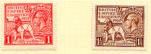
What had been Wembley Park hosted the British Empire Exhibition of 1924–1925. Most of the rest of Wembley’s housing consists of inter-war semi-detached houses and terraces.
Post-war

During the 1960s, rebuilding of Wembley Central station, a block of flats, an open-plan shopping plaza, and a car park were constructed on a concrete raft over the railway. The retail centre of Wembley (the High Road and north end of Ealing Road) has suffered from chronic traffic congestion and from the opening of neighbouring purpose-built shopping centres.
Recent regenerations

The town’s regeneration is one of the major development projects in London in the early 21st century. A shopping plaza along High Road suffered slow decline by the 1980s and was poorly maintained. In a bid to reverse Wembley’s fortunes, in the mid-2000s plans were created and approved to completely regenerate the place, carried out by construction company St. Modwen.
Wembley landmarks
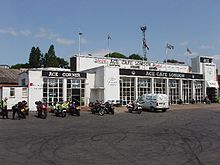
The prime landmark is Wembley Stadium, rebuilt 2003–07 at a cost of £827 million. Wembley Point, formerly Station House, is a 21-storey building next to Stonebridge Park station. The Ace Cafe is unusually a transport café, re-opening in 1997 after decades of closure.
Wembley geography / climate

Wembley is made up of six wards: Wembley Central, Alperton, Tokyngton, Barnhill, Preston and Sudbury. The area is identified in the Mayor of London’s London Plan as one of thirty-five major centres in Greater London. Wembley is part of both HA0 and HA9 post codes, and has its own post town.
Why visit Wembley with Walkfo Travel Guide App?
 You can visit Wembley places with Walkfo Wembley to hear history at Wembley’s places whilst walking around using the free digital tour app. Walkfo Wembley has 144 places to visit in our interactive Wembley map, with amazing history, culture & travel facts you can explore the same way you would at a museum or art gallery with information audio headset. With Walkfo, you can travel by foot, bike or bus throughout Wembley, being in the moment, without digital distraction or limits to a specific walking route. Our historic audio walks, National Trust interactive audio experiences, digital tour guides for English Heritage locations are available at Wembley places, with a AI tour guide to help you get the best from a visit to Wembley & the surrounding areas.
“Curated content for millions of locations across the UK, with 144 audio facts unique to Wembley places in an interactive Wembley map you can explore.”
Walkfo: Visit Wembley Places Map
144 tourist, history, culture & geography spots
Wembley historic spots | Wembley tourist destinations | Wembley plaques | Wembley geographic features |
| Walkfo Wembley tourism map key: places to see & visit like National Trust sites, Blue Plaques, English Heritage locations & top tourist destinations in Wembley | |||
Best Wembley places to visit
Wembley has places to explore by foot, bike or bus. Below are a selection of the varied Wembley’s destinations you can visit with additional content available at the Walkfo Wembley’s information audio spots:
 | Hanger Hill Hanger Hill or Haymills Estate is a local area and ward of the London Borough of Ealing . It was developed in the interwar period when affluent Londoners moved out of Central London for more green spaces . The estate features spacious houses and flats designed by architects Douglas Smith and Barley . |
 | Hanger Hill Wood Hanger Hill Wood is a small remnant of ancient woodland to the east of the Hanger Hill Park and North Circular Road at Hanger Lane in Ealing in the London Borough of Ealing . Named from ‘Hangra’, the Old English word for wooded slope . |
 | St Peter’s Church, Ealing St Peter’s Church is an Anglican parish church in North Ealing, in the Diocese of London . Grade II* Listed building is noted for its combination of Arts & Crafts and late-Victorian Gothic . |
 | Horsenden Hill Horsenden Hill is a hill and open space in West London . It is one of the higher eminences in the local area, rising to 85m (276 ft) above sea level . The summit forms part of an ancient hillfort and is the site of a trig point . |
 | Castlebar Hill Castlebar Hill is 167 feet (51 m) high . In the 18th century, it was the location of Castle Beare, a grand mansion or country seat . |
 | Stonebridge Park power station Stonebridge Park power station was a private supply electricity generating station in Wembley north west London. It supplied direct current electricity to the adjacent Euston to Watford electric railway lines from 1914 to 1967. |
Visit Wembley plaques
 21
21
plaques
here Wembley has 21 physical plaques in tourist plaque schemes for you to explore via Walkfo Wembley plaques audio map when visiting. Plaques like National Heritage’s “Blue Plaques” provide visual geo-markers to highlight points-of-interest at the places where they happened – and Walkfo’s AI has researched additional, deeper content when you visit Wembley using the app. Experience the history of a location when Walkfo local tourist guide app triggers audio close to each Wembley plaque. Explore Plaques & History has a complete list of Hartlepool’s plaques & Hartlepool history plaque map.


 Trying to encourage visitors to Wembley?