Welcome to Visit Warley, West Midlands Places
The Walkfo guide to things to do & explore in Warley, West Midlands
![]() Visit Warley, West Midlands places using Walkfo for free guided tours of the best Warley, West Midlands places to visit. A unique way to experience Warley, West Midlands’s places, Walkfo allows you to explore Warley, West Midlands as you would a museum or art gallery with audio guides.
Visit Warley, West Midlands places using Walkfo for free guided tours of the best Warley, West Midlands places to visit. A unique way to experience Warley, West Midlands’s places, Walkfo allows you to explore Warley, West Midlands as you would a museum or art gallery with audio guides.
Visiting Warley, West Midlands Walkfo Preview
When you visit Warley, West Midlands, Walkfo brings Warley, West Midlands places to life as you travel by foot, bike, bus or car with a mobile phone & headphones.
Warley, West Midlands Places Overview: History, Culture & Facts about Warley, West Midlands
Visit Warley, West Midlands – Walkfo’s stats for the places to visit
With 74 audio plaques & Warley, West Midlands places for you to explore in the Warley, West Midlands area, Walkfo is the world’s largest heritage & history digital plaque provider. The AI continually learns & refines facts about the best Warley, West Midlands places to visit from travel & tourism authorities (like Wikipedia), converting history into an interactive audio experience.
Warley, West Midlands history
A civil parish of Warley was created in 1884 by the merger of the Warley Salop and Ridgacre parishes. In 1908 the parish was abolished, becoming part of the municipal borough of Oldbury. The Warley name was retained as the name of a district which was developed for housing after 1920.
Why visit Warley, West Midlands with Walkfo Travel Guide App?
![]() You can visit Warley, West Midlands places with Walkfo Warley, West Midlands to hear history at Warley, West Midlands’s places whilst walking around using the free digital tour app. Walkfo Warley, West Midlands has 74 places to visit in our interactive Warley, West Midlands map, with amazing history, culture & travel facts you can explore the same way you would at a museum or art gallery with information audio headset. With Walkfo, you can travel by foot, bike or bus throughout Warley, West Midlands, being in the moment, without digital distraction or limits to a specific walking route. Our historic audio walks, National Trust interactive audio experiences, digital tour guides for English Heritage locations are available at Warley, West Midlands places, with a AI tour guide to help you get the best from a visit to Warley, West Midlands & the surrounding areas.
You can visit Warley, West Midlands places with Walkfo Warley, West Midlands to hear history at Warley, West Midlands’s places whilst walking around using the free digital tour app. Walkfo Warley, West Midlands has 74 places to visit in our interactive Warley, West Midlands map, with amazing history, culture & travel facts you can explore the same way you would at a museum or art gallery with information audio headset. With Walkfo, you can travel by foot, bike or bus throughout Warley, West Midlands, being in the moment, without digital distraction or limits to a specific walking route. Our historic audio walks, National Trust interactive audio experiences, digital tour guides for English Heritage locations are available at Warley, West Midlands places, with a AI tour guide to help you get the best from a visit to Warley, West Midlands & the surrounding areas.
“Curated content for millions of locations across the UK, with 74 audio facts unique to Warley, West Midlands places in an interactive Warley, West Midlands map you can explore.”
Walkfo: Visit Warley, West Midlands Places Map
74 tourist, history, culture & geography spots
Warley, West Midlands historic spots | Warley, West Midlands tourist destinations | Warley, West Midlands plaques | Warley, West Midlands geographic features |
| Walkfo Warley, West Midlands tourism map key: places to see & visit like National Trust sites, Blue Plaques, English Heritage locations & top tourist destinations in Warley, West Midlands | |||
Best Warley, West Midlands places to visit
Warley, West Midlands has places to explore by foot, bike or bus. Below are a selection of the varied Warley, West Midlands’s destinations you can visit with additional content available at the Walkfo Warley, West Midlands’s information audio spots:
 | The Leasowes The Leasowes is a 57-hectare (around 141 acre) estate in Halesowen, historically in Shropshire, England . The name means “rough pasture land” The estate is now listed Grade I on English Heritage’s Register of Parks and Gardens . |
 | St Faith and St Laurence’s Church, Harborne St. Faith and St. Laurence’s Church, Harborne is a parish church in Harborne, Birmingham . It is part of the Anglican Diocese of Birmingham, and a member of Inclusive Church . |
 | Sandwell Sandwell is a metropolitan borough of the West Midlands county in England . The borough is named after the Sandwell Priory and spans a densely populated part of the Midlands conurbation . At the 2011 census, the borough had a population of 309,000 and an area of 86 square kilometres (33 sq mi) In 2019 Sandwell was ranked 12th most deprived of England’s 317 boroughs . |
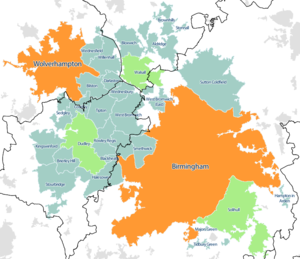
 | West Midlands conurbation The West Midlands conurbation includes the cities of Birmingham and Wolverhampton and the towns of Sutton Coldfield, Dudley, Walsall, West Bromwich, Solihull, Stourbridge and Halesowen. According to the 2011 Census the area had a population of 2,440,986, making it the third most populated in the United Kingdom behind the Greater London and Greater Manchester Built Up Areas. Not to be confused with the region or metropolitan county of the same name. |
 | Portway Hill Portway Hill is part of the Rowley Hills, near Rowley Regis in West Midlands. It is the site of a nature reserve of the Wildlife Trust for Birmingham and the Black Country. |
 | Turners Hill, West Midlands The hill is in the Rowley Hills range, situated in Rowley Regis, near the boundary with Dudley. There are good views of the hill from the M5 Motorway between Junctions 1 and 2. |
 | Rowley Regis Hospital Rowley Regis Community Hospital is a hospital in West Midlands. It is managed by the Sandwell and West Birmingham Hospitals NHS Trust. |
Visit Warley, West Midlands plaques
![]() 25
25
plaques
here Warley, West Midlands has 25 physical plaques in tourist plaque schemes for you to explore via Walkfo Warley, West Midlands plaques audio map when visiting. Plaques like National Heritage’s “Blue Plaques” provide visual geo-markers to highlight points-of-interest at the places where they happened – and Walkfo’s AI has researched additional, deeper content when you visit Warley, West Midlands using the app. Experience the history of a location when Walkfo local tourist guide app triggers audio close to each Warley, West Midlands plaque. Explore Plaques & History has a complete list of Hartlepool’s plaques & Hartlepool history plaque map.