Welcome to Visit Wall, Staffordshire Places
The Walkfo guide to things to do & explore in Wall, Staffordshire
 Visit Wall, Staffordshire places using Walkfo for free guided tours of the best Wall, Staffordshire places to visit. A unique way to experience Wall, Staffordshire’s places, Walkfo allows you to explore Wall, Staffordshire as you would a museum or art gallery with audio guides.
Visiting Wall, Staffordshire Walkfo Preview
Wall is a small village and civil parish in Staffordshire, England. It lies on the site of the Roman settlement of Letocetum. The nearby junction of the A5 and A5127 roads and the M6 Toll motorway is often referred to as ‘Wall Island’ When you visit Wall, Staffordshire, Walkfo brings Wall, Staffordshire places to life as you travel by foot, bike, bus or car with a mobile phone & headphones.
Wall, Staffordshire Places Overview: History, Culture & Facts about Wall, Staffordshire
Visit Wall, Staffordshire – Walkfo’s stats for the places to visit
With 41 audio plaques & Wall, Staffordshire places for you to explore in the Wall, Staffordshire area, Walkfo is the world’s largest heritage & history digital plaque provider. The AI continually learns & refines facts about the best Wall, Staffordshire places to visit from travel & tourism authorities (like Wikipedia), converting history into an interactive audio experience.
Wall, Staffordshire history
Letocetum
First detailed evidence of human settlement comes in the 1st century. Roman fort named Etocetum was established at Wall in or soon after AD 50 to accommodate Legio XIV, then advancing towards Wales. In the 2nd century the settlement covered approximately 30 acres (12 ha) west of Wall Lane.
Modern Wall
Development of Wall since the Romans has been slow, and it has never developed beyond a small village. In 1839 the church was built, and in 1843 was consecrated as the Church of England parish church of St John. The re-routing of the A5 around Wall in 1965 relieved the village of traffic, re-establishing its quiet nature.
Wall, Staffordshire geography / climate
The upper part of Wall village lies at an elevation of 114 m on the edge of a plateau. The lower part to the south of Watling Street lies 16 m lower. The north of the parish including Pipehill, Aldershawe and east parts of Wall are underlain with Bromsgrove Sandstone.
Why visit Wall, Staffordshire with Walkfo Travel Guide App?
 You can visit Wall, Staffordshire places with Walkfo Wall, Staffordshire to hear history at Wall, Staffordshire’s places whilst walking around using the free digital tour app. Walkfo Wall, Staffordshire has 41 places to visit in our interactive Wall, Staffordshire map, with amazing history, culture & travel facts you can explore the same way you would at a museum or art gallery with information audio headset. With Walkfo, you can travel by foot, bike or bus throughout Wall, Staffordshire, being in the moment, without digital distraction or limits to a specific walking route. Our historic audio walks, National Trust interactive audio experiences, digital tour guides for English Heritage locations are available at Wall, Staffordshire places, with a AI tour guide to help you get the best from a visit to Wall, Staffordshire & the surrounding areas.
“Curated content for millions of locations across the UK, with 41 audio facts unique to Wall, Staffordshire places in an interactive Wall, Staffordshire map you can explore.”
Walkfo: Visit Wall, Staffordshire Places Map
41 tourist, history, culture & geography spots
Wall, Staffordshire historic spots | Wall, Staffordshire tourist destinations | Wall, Staffordshire plaques | Wall, Staffordshire geographic features |
| Walkfo Wall, Staffordshire tourism map key: places to see & visit like National Trust sites, Blue Plaques, English Heritage locations & top tourist destinations in Wall, Staffordshire | |||
Best Wall, Staffordshire places to visit
Wall, Staffordshire has places to explore by foot, bike or bus. Below are a selection of the varied Wall, Staffordshire’s destinations you can visit with additional content available at the Walkfo Wall, Staffordshire’s information audio spots:
 | St Matthew’s Hospital St Matthew’s Hospital was a mental health facility in Burntwood, Staffordshire, England. It was located in Nightingale Walk, Burntwal, and was established in the 1960s. The hospital was known for its mental health facilities. |
 | Bishop’s Palace, Lichfield The Bishop’s Palace is a 17th-century building situated in the north east corner of the Cathedral Close in Lichfield, Staffordshire. The first palace was destroyed during the English Civil War and rebuilt in 1687. The palace was residence to the Bishop of Lichfield from the late 1860s until 1954, it is now used by Lichfield Cathedral School. |
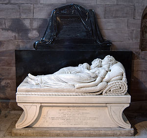 | The Sleeping Children The Sleeping Children is a marble sculpture by Francis Chantrey. It depicts Ellen-Jane and Marianne Robinson asleep in each other’s arms on a bed. The statue was placed in the south east corner of Lichfield Cathedral in 1817. The work is considered to be one of the greatest works of English sculpture during the period. |
 | Siege of Lichfield The Siege of Lichfield occurred on 8–21 April 1643 during the First English Civil War. Royalists under the command of Prince Rupert successfully besieged the Parliamentary garrison. |
 | Cathedral Close, Lichfield The Cathedral Close is a historic set of buildings surrounding Lichfield Cathedral in Lichfield. The Close comprises buildings associated with the cathedral and the clergy which encircle the Cathedral. The majority of buildings date from the 17th, 18th and 19th centuries. |
 | Guildhall, Lichfield The Guildhall is a Grade II listed building in Lichfield, Staffordshire. The guildhall is located in Bore Street, Lichfield in the United Kingdom. |
 | St Michael on Greenhill, Lichfield St Michael on Greenhill is a parish church in Lichfield, Staffordshire. It is located on the high ground of Greenhill in the east of the city. A church has been on the present site since at least 1190 but the current building dates mainly from the restoration of 1842–43. The churchyard is one of five ancient burial grounds in England. |
 | Lichfield District Lichfield (UK: /ˈlɪtʃˌfiːld) is a local government district in Staffordshire. It is administered by Lichfield District Council, based in Lichfield. The district was formed on 1 April 1974, under the Local Government Act 1972, by a merger of the existing City of Lichfield with most of the Lichfield Rural District. |
 | Hospital of St John Baptist without the Barrs The Hospital of St John Baptist without the Barrs is a Grade I listed building in Lichfield, Staffordshire. It once provided accommodation to travellers outside the southern city walls. The distinctive eight chimneys fronting St John’s Street date back to the Tudor period when the hospital served as an almshouse for elderly gentlemen. |
 | Lichfield Clock Tower Lichfield Clock Tower or Friary Clock Tower is a 19th-century Grade II listed clock tower located on ‘The Friary’ south of Festival Gardens in the city of Lichfield, Staffordshire. The tower was erected in 1863 at the junction of Bird Street and Bore Street over the site of the ancient Crucifix Conduit. |
Visit Wall, Staffordshire plaques
 30
30
plaques
here Wall, Staffordshire has 30 physical plaques in tourist plaque schemes for you to explore via Walkfo Wall, Staffordshire plaques audio map when visiting. Plaques like National Heritage’s “Blue Plaques” provide visual geo-markers to highlight points-of-interest at the places where they happened – and Walkfo’s AI has researched additional, deeper content when you visit Wall, Staffordshire using the app. Experience the history of a location when Walkfo local tourist guide app triggers audio close to each Wall, Staffordshire plaque. Explore Plaques & History has a complete list of Hartlepool’s plaques & Hartlepool history plaque map.


 Trying to encourage visitors to Wall, Staffordshire?