Visit Vale of Glamorgan Place – things to do & explore
 Visit Vale of Glamorgan places on a day-trip, weekend away or holiday – and Walkfo becomes your personal digital tour guide to Vale of Glamorgan things to do.
Visiting Vale of Glamorgan Overview
The Vale of Glamorgan is a principal area with county borough status . It borders Cardiff, Cardiff, Rhondda Cynon Taf, Bridgend County Borough to the west, Cardiff to the east and the Bristol Channel to the south . It is the southernmost unitary authority in Wales . The largest town is Barry, with Penarth, Llantwit Major and Cowbridge .
When you visit Vale of Glamorgan, Vale of Glamorgan history becomes available at the places you travel to by foot, bike, bus or car with a mobile phone & headphones.
Vale of Glamorgan places overview by Walkfo
Visit to Vale of Glamorgan stats
 With 213 tourism audio plaques & places for you to explore in Vale of Glamorgan, Walkfo is the world’s largest heritage & history digital plaque provider in the world. Our AI continually learns & refines content about the best Vale of Glamorgan places to visit from online information authorities like Wikipedia for current & history, and converts it into an audio experience.
Vale of Glamorgan history
In medieval times, the village of Cosmeston grew up around a fortified manor house. The De Costentins were among the first Norman invaders of Wales in the early 12th century. Between the 11th-century and 1536 the area was part of the Lordship of Glamorgan. Clemenstone, to the west, was the seat of several high sheriffs, including John Curre. Lady Sale née Wynch, wife of Sir Robert Sale, spent much of her early life on the estate.
Vale of Glamorgan landmarks
See Listed buildings in the Vale of Glamorgan, List of Scheduled Monuments in Vale of Glamorgan. List of listed buildings is also included in List of Sites of National Register of Monuments.
Vale of Glamorgan geography / climate
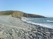
The Vale of Glamorgan covers 33,097 hectares (130 square miles) and has 53 km (33 mi) of coastline. The largest centre of population is Barry (51,502 inhabitants) Other towns include Cowbridge (6,180), Dinas Powys (7,799), Llantwit Major (10,621) and Penarth (22,083) The area is low-lying, with a maximum height of 137.3 metres (450 ft) above sea level.
When you visit Vale of Glamorgan
You can visit Vale of Glamorgan places and use Walkfo Vale of Glamorgan to discover the history & things to do in Vale of Glamorgan whilst walking with our free digital tour app. Walkfo Vale of Glamorgan has 213 places on our Vale of Glamorgan map with history, culture & travel facts that you explore the same way you would at a museum or art gallery with information audio headset. With Walkfo, you can travel by foot, bike or bus throughout Vale of Glamorgan, being in the moment, without digital distraction or limits to a specific walking route – you choose where you want to go, when you want to go and Walkfo Vale of Glamorgan will keep up.
–
With millions of places including tourist walks, Vale of Glamorgan travel destinations, National Trust locations converted to audio experiences, our Vale of Glamorgan places AI guide will help you get the best from your visit to Vale of Glamorgan & the surrounding areas. The Vale of Glamorgan places app for iPhone & Android delivers hidden history, interesting culture and amazing facts in interactive audio stories in response to where you walk at National Heritage sites, tourist attractions, historic locations or city streets, with no predefined walk map requirements.
“The Walkfo AI has curated content for millions of locations across the UK, with 213 audio facts unique to Vale of Glamorgan places forming an interactive Vale of Glamorgan map for you to explore.”
Walkfo’s Visit Vale of Glamorgan Places Map
213 tourist, history, culture & geography spots
Vale of Glamorgan historic spot | Vale of Glamorgan tourist destination | Vale of Glamorgan plaque | Vale of Glamorgan geographic feature |
| Walkfo Vale of Glamorgan tourism map key: places to see & visit like National Trust sites, Blue Plaques, English Heritage locations & top tourist destinations in Vale of Glamorgan | |||
Best Vale of Glamorgan places to visit
Vale of Glamorgan has many places to explore by foot, bike or bus. Below are a selection of the varied Vale of Glamorgan’s destinations you can visit with additional content available at the Walkfo Vale of Glamorgan’s information audio spots:
 | Barry Island Barry Island (Welsh: Ynys y Barri) is a district, peninsula and seaside resort. It is named after the 6th century Saint Baruc. The peninsula was an island until the 1880s when it was linked to the mainland. It was used as a setting of the BBC TV shows Gavin & Stacey and Being Human. |
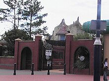 | Barry Island Pleasure Park Barry Island Pleasure Park is situated on the coast at Barry Island in the Vale of Glamorgan, about 10 mi (16 km) south west of the capital city Cardiff, Wales. The park was once famous for its Scenic Railway which dominated half of the site in the mid-20th century, but was partially destroyed in a gale in 1973 before being dismantled. |
 | Colcot Dyfan ward is situated in the north west of Barry and its most northern edge is on the green belt of the town. It also contains the Colcot Arms pub, the St David’s Methodist Church, Coastlands Family Church, a fish and chip shop/Chinese takeaway, Barry Arts Centre and Merthyr Dyfan Cemetery. |
 | Gibbonsdown Gibbonsdown, colloquially known as ‘Gibby’, is a residential area and electoral ward situated in the north east of Barry in the Vale of Glamorgan, Wales. It borders Merthyr Dyfan to the northwest and Cadoxton to the southeast. |
 | Cadoxton Court Dovecote Cadoxton Court Dovecote is a medieval structure dating from the 13th century. It is the largest of the remaining medieval dovecotes in the Vale and a Grade I listed building. |
 | Cadoxton, Vale of Glamorgan Cadoxton is a district of Barry in the Vale of Glamorgan, Wales. It was once originally its own village, separate from Barry. It grew up around Saint Cadoc’s parish church, which survives. |
 | Dinas Powys F.C. Dinas Powys F.C. play in the Ardal Leagues South West, which is tier 3 of the Welsh football pyramid. They have an academy with over 100 players. |
 | St. Andrews Major St. Andrew’s Major (Welsh: Saint Andras) is a village and parish in the community of Dinas Powys in the Vale of Glamorgan, south-eastern Wales. |
 | Michaelston-le-Pit Michaelston-le-Pit (Welsh: Llanfihangel-y-pwll) is a village in the Vale of Glamorgan, just to the west of the city of Cardiff, Wales. The community population taken at the 2011 census was 309. The village is built near the confluence of two small streams which join to form the Cadoxton River. |
 | Wrinstone The Wrinstone estate was variously also known as Wrenston, Wrencheston or Wrenchester. The Barry Railway line ran past the hamlet and entered the Wenvoe Tunnel. It closed after a fire in 1963. |
Visit Vale of Glamorgan plaques
 11
11
plaques
here Vale of Glamorgan has 11 physical plaques within tourist plaque schemes for you to explore via Walkfo Vale of Glamorgan plaques when visiting. Plaque schemes such as National Heritage’s “Blue Plaques” provide visual geo-markers to highlight points-of-interest at the places where they happened. Where a plaque is available, Walkfo AI has done research to provide additional, deeper content when you visit Vale of Glamorgan using the app. Experience hidden history & stories at each location as the Walkfo local tourist guide app uses trigger audio close to each Vale of Glamorgan plaque. Explore Vale of Glamorgan Plaques & History has a complete list of Hartlepool’s plaques & Hartlepool history plaque map.


 Trying to encourage visitors to Vale of Glamorgan?