Welcome to Visit Urmston Places
The Walkfo guide to things to do & explore in Urmston
 Visit Urmston places using Walkfo for free guided tours of the best Urmston places to visit. A unique way to experience Urmston’s places, Walkfo allows you to explore Urmston as you would a museum or art gallery with audio guides.
Visiting Urmston Walkfo Preview
Urmston covers an area of 4,799 acres (19 km) It is 5 miles (8 km) southwest of Manchester city centre. The town has early medieval origins, and until the arrival of the railway in 1873 was a small farming community. When you visit Urmston, Walkfo brings Urmston places to life as you travel by foot, bike, bus or car with a mobile phone & headphones.
Urmston Places Overview: History, Culture & Facts about Urmston
Visit Urmston – Walkfo’s stats for the places to visit
With 44 audio plaques & Urmston places for you to explore in the Urmston area, Walkfo is the world’s largest heritage & history digital plaque provider. The AI continually learns & refines facts about the best Urmston places to visit from travel & tourism authorities (like Wikipedia), converting history into an interactive audio experience.
Urmston history
The name Urmston is likely to be derived from Orme’s Easton, or Ormestun, the “tun” or dwelling of Orme Fitz Seward. In the early 13th century, Lord Greenhalgh and his family lived at Highfield House (under what is now the M60 motorway) The town was home to the first District heating system in England. The opening of the Cheshire Lines Railway in 1873 allowed the town to grow as a commuter town.
Urmston culture & places
Cultural events and venues
Urmston Musical Theatre was formed in 1911 and is president of the current president is actor Matthew Kelly. Canterbury Players is a local amateur dramatic society. The only survivor is the New Curzon, which opened in 1931 as a cinema and bingo club.
The Beatles
In 1963 the council booked the Beatles to play at the Urmston Show at Abbotsfield Park in Chassen Road on Monday 5 August. At the time of the booking, they were not well known, but had risen in popularity by the time they played.
Sport
Urmston Cricket Club was founded in 1846 and has been located on Moorside Road since 1870. The club has two leisure centres owned by Trafford Council: Move Urmst and George H Carnall.
Urmston geography / climate

Urmston occupies an area of 7.5 square miles (19.4 km), at 53°26′55″N 2°22′29″W / 53.44861°N 2.37472°W – -2.3747. The land is relatively flat, sloping gently from north to south. The mean temperature is slightly above average for the United Kingdom.
Why visit Urmston with Walkfo Travel Guide App?
 You can visit Urmston places with Walkfo Urmston to hear history at Urmston’s places whilst walking around using the free digital tour app. Walkfo Urmston has 44 places to visit in our interactive Urmston map, with amazing history, culture & travel facts you can explore the same way you would at a museum or art gallery with information audio headset. With Walkfo, you can travel by foot, bike or bus throughout Urmston, being in the moment, without digital distraction or limits to a specific walking route. Our historic audio walks, National Trust interactive audio experiences, digital tour guides for English Heritage locations are available at Urmston places, with a AI tour guide to help you get the best from a visit to Urmston & the surrounding areas.
“Curated content for millions of locations across the UK, with 44 audio facts unique to Urmston places in an interactive Urmston map you can explore.”
Walkfo: Visit Urmston Places Map
44 tourist, history, culture & geography spots
Urmston historic spots | Urmston tourist destinations | Urmston plaques | Urmston geographic features |
| Walkfo Urmston tourism map key: places to see & visit like National Trust sites, Blue Plaques, English Heritage locations & top tourist destinations in Urmston | |||
Best Urmston places to visit
Urmston has places to explore by foot, bike or bus. Below are a selection of the varied Urmston’s destinations you can visit with additional content available at the Walkfo Urmston’s information audio spots:
 | Chill Factore Chill Factor is the UK’s longest indoor ski slope; a £31M real snow centre . Designed by FaulknerBrowns Architects, the centre opened in November 2007 at which time it was the widest in the world, at 180 metres (590 ft) long . |
 | St George’s Church, Carrington St George’s Church is in the village of Carrington, Trafford, Greater Manchester. It is recorded in the National Heritage List for England as a designated Grade II* listed building. It stands in a relatively isolated position south of the Manchester Ship Canal. |
 | Glazebrook East Junction–Skelton Junction line Glazebrook East Junction–Skelton Junction line was a railway line. It was a line from Glazbrook, Greater Manchester, to Skelton. It ran between Glazabrook and Skelon Junction in Greater Manchester. |
 | St Martin’s Church, Ashton upon Mersey St Martin’s Church is in Church Lane, Ashton upon Mersey, a district of Sale, Greater Manchester. It is recorded in the National Heritage List for England as a designated Grade II* listed building. |
 | Flixton House Flixton House was built in 1806 by the Wright family, who had become wealthy land owners. Ralph Wright in 1826 closed several footpaths across his estate, which the public had until then been allowed access to. In response to the closure, the people of Flixon initiated and funded a court case against Wright, one of the first footpath battles in England. |
 | St Michael’s Church, Flixton St Michael’s Church, Flixton, Greater Manchester, is an Anglican parish church dedicated to Michael the Archangel. It lies in the Diocese of Manchester, in the Anglican Diocese previously in Lichfield. |
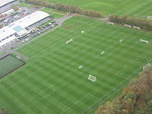 | Trafford Training Centre Trafford Training Centre is the training ground and academy headquarters of English football club Manchester United F.C. It is near the village of Carrington, Greater Manchester, and replaced The Cliff as the club’s training ground in 2000. The main building was opened and the first team moved in in 2000, followed by the Academy facility in 2002. |
 | Irlam (ward) Irlam is an electoral ward of Salford, England. It is represented in Westminster by Barbara Keeley MP for Worsley and Eccles South. |
Visit Urmston plaques
 7
7
plaques
here Urmston has 7 physical plaques in tourist plaque schemes for you to explore via Walkfo Urmston plaques audio map when visiting. Plaques like National Heritage’s “Blue Plaques” provide visual geo-markers to highlight points-of-interest at the places where they happened – and Walkfo’s AI has researched additional, deeper content when you visit Urmston using the app. Experience the history of a location when Walkfo local tourist guide app triggers audio close to each Urmston plaque. Explore Plaques & History has a complete list of Hartlepool’s plaques & Hartlepool history plaque map.


 Trying to encourage visitors to Urmston?