Welcome to Visit Upton St Leonards Places
The Walkfo guide to things to do & explore in Upton St Leonards
![]() Visit Upton St Leonards places using Walkfo for free guided tours of the best Upton St Leonards places to visit. A unique way to experience Upton St Leonards’s places, Walkfo allows you to explore Upton St Leonards as you would a museum or art gallery with audio guides.
Visit Upton St Leonards places using Walkfo for free guided tours of the best Upton St Leonards places to visit. A unique way to experience Upton St Leonards’s places, Walkfo allows you to explore Upton St Leonards as you would a museum or art gallery with audio guides.
Visiting Upton St Leonards Walkfo Preview
Upton St Leonards is a village in the Gloucestershire district of Stroud. It is a mile or so north of the A46 road between Stroud and Cheltenham. When you visit Upton St Leonards, Walkfo brings Upton St Leonards places to life as you travel by foot, bike, bus or car with a mobile phone & headphones.
Upton St Leonards Places Overview: History, Culture & Facts about Upton St Leonards
Visit Upton St Leonards – Walkfo’s stats for the places to visit
With 36 audio plaques & Upton St Leonards places for you to explore in the Upton St Leonards area, Walkfo is the world’s largest heritage & history digital plaque provider. The AI continually learns & refines facts about the best Upton St Leonards places to visit from travel & tourism authorities (like Wikipedia), converting history into an interactive audio experience.
Why visit Upton St Leonards with Walkfo Travel Guide App?
![]() You can visit Upton St Leonards places with Walkfo Upton St Leonards to hear history at Upton St Leonards’s places whilst walking around using the free digital tour app. Walkfo Upton St Leonards has 36 places to visit in our interactive Upton St Leonards map, with amazing history, culture & travel facts you can explore the same way you would at a museum or art gallery with information audio headset. With Walkfo, you can travel by foot, bike or bus throughout Upton St Leonards, being in the moment, without digital distraction or limits to a specific walking route. Our historic audio walks, National Trust interactive audio experiences, digital tour guides for English Heritage locations are available at Upton St Leonards places, with a AI tour guide to help you get the best from a visit to Upton St Leonards & the surrounding areas.
You can visit Upton St Leonards places with Walkfo Upton St Leonards to hear history at Upton St Leonards’s places whilst walking around using the free digital tour app. Walkfo Upton St Leonards has 36 places to visit in our interactive Upton St Leonards map, with amazing history, culture & travel facts you can explore the same way you would at a museum or art gallery with information audio headset. With Walkfo, you can travel by foot, bike or bus throughout Upton St Leonards, being in the moment, without digital distraction or limits to a specific walking route. Our historic audio walks, National Trust interactive audio experiences, digital tour guides for English Heritage locations are available at Upton St Leonards places, with a AI tour guide to help you get the best from a visit to Upton St Leonards & the surrounding areas.
“Curated content for millions of locations across the UK, with 36 audio facts unique to Upton St Leonards places in an interactive Upton St Leonards map you can explore.”
Walkfo: Visit Upton St Leonards Places Map
36 tourist, history, culture & geography spots
Upton St Leonards historic spots | Upton St Leonards tourist destinations | Upton St Leonards plaques | Upton St Leonards geographic features |
| Walkfo Upton St Leonards tourism map key: places to see & visit like National Trust sites, Blue Plaques, English Heritage locations & top tourist destinations in Upton St Leonards | |||
Best Upton St Leonards places to visit
Upton St Leonards has places to explore by foot, bike or bus. Below are a selection of the varied Upton St Leonards’s destinations you can visit with additional content available at the Walkfo Upton St Leonards’s information audio spots:
 | Brockworth Brockworth is a parish, village and district of Gloucester in Gloucestershire . It is located 4 miles southeast of central Gloucester, 6 miles southwest of Cheltenham and 11.5 miles (18.5 km) north of Stroud . During World War II the nearby village of Hucclecote at the Gloster Aircraft Company produced the famous Hawker Hurricane fighter . |
 | Coopers Edge Coopers Edge is a new build suburb situated in Brockworth, Gloucester, between the city of Gloucester and the town of Cheltenham . Building began in 2007 at the foot of Coopers Hill . |
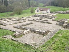
 | Great Witcombe Roman Villa Great Witcombe Roman Villa was a villa built during the Roman occupation of Britain . It is located on a hillside near Gloucester in the English county of Gloucestershire . |
 | Hucclecote Meadows Hucclecote Meadows (grid reference SO872163) is a 5.74-hectare (14.2-acre) biological Site of Special Scientific Interest . The western area is also a Local Nature Reserve . |
 | Matson, Gloucester Matson is a suburb in the City of Gloucester, Gloucestershire, England. It is located on the outskirts of the city centre. |
 | Tredworth Road Cemetery Tredworth Road Cemetery, sometimes known as Gloucester Old Cemetery, is a cemetery in Gloucester, England. It contains over 250 war graves maintained by the Commonwealth War Graves Commission. The cemetery chapel is a grade II listed building. |
 | Coney Hill Hospital Coney Hill Hospital was a mental health facility in Gloucester, England. It was located on the outskirts of Gloucester in the 1960s and 1960s. |
 | St Barnabas Church, Gloucester St Barnabas Church is a Grade II listed building in Gloucester, Gloucestershire. It was built in 1938–40 and obtained its Grade II status on 9 March 1982. The church’s denomination is the Church of England. |
 | Robin’s Wood Hill Quarry Robin’s Wood Hill Quarry (grid reference SO836148) is a 1.67-hectare (4.1-acre) geological Site of Special Scientific Interest in Gloucestershire, on Robinswood Hill. |
 | Range Farm Fields Range Farm Fields (grid reference SO850130) is a 12.8-hectare (32-acre) biological Site of Special Scientific Interest in Gloucestershire, near to Gloucester City, notified in 1996. |
Visit Upton St Leonards plaques
![]() 0
0
plaques
here Upton St Leonards has 0 physical plaques in tourist plaque schemes for you to explore via Walkfo Upton St Leonards plaques audio map when visiting. Plaques like National Heritage’s “Blue Plaques” provide visual geo-markers to highlight points-of-interest at the places where they happened – and Walkfo’s AI has researched additional, deeper content when you visit Upton St Leonards using the app. Experience the history of a location when Walkfo local tourist guide app triggers audio close to each Upton St Leonards plaque. Currently No Physical Plaques.