Welcome to Visit Upper Slaughter Places
The Walkfo guide to things to do & explore in Upper Slaughter
 Visit Upper Slaughter places using Walkfo for free guided tours of the best Upper Slaughter places to visit. A unique way to experience Upper Slaughter’s places, Walkfo allows you to explore Upper Slaughter as you would a museum or art gallery with audio guides.
Visiting Upper Slaughter Walkfo Preview
Upper Slaughter is 4 miles (6.4 km) south west of Stow-on-the-Wold. The village is built on both banks of the River Eye. Upper Slaughter was one of the Thankful Villages in England which lost no men in World War I. When you visit Upper Slaughter, Walkfo brings Upper Slaughter places to life as you travel by foot, bike, bus or car with a mobile phone & headphones.
Upper Slaughter Places Overview: History, Culture & Facts about Upper Slaughter
Visit Upper Slaughter – Walkfo’s stats for the places to visit
With 17 audio plaques & Upper Slaughter places for you to explore in the Upper Slaughter area, Walkfo is the world’s largest heritage & history digital plaque provider. The AI continually learns & refines facts about the best Upper Slaughter places to visit from travel & tourism authorities (like Wikipedia), converting history into an interactive audio experience.
Upper Slaughter history
The name of the village derives from the Old English term “slough” meaning “wet land” The manor of Upper Slaughter is recorded in the Domesday Book of 1086. Upper Slaughter was the site of an adulterine castle, built by supporters of the Empress Matilda during The Anarchy of the 12th century.
Why visit Upper Slaughter with Walkfo Travel Guide App?
 You can visit Upper Slaughter places with Walkfo Upper Slaughter to hear history at Upper Slaughter’s places whilst walking around using the free digital tour app. Walkfo Upper Slaughter has 17 places to visit in our interactive Upper Slaughter map, with amazing history, culture & travel facts you can explore the same way you would at a museum or art gallery with information audio headset. With Walkfo, you can travel by foot, bike or bus throughout Upper Slaughter, being in the moment, without digital distraction or limits to a specific walking route. Our historic audio walks, National Trust interactive audio experiences, digital tour guides for English Heritage locations are available at Upper Slaughter places, with a AI tour guide to help you get the best from a visit to Upper Slaughter & the surrounding areas.
“Curated content for millions of locations across the UK, with 17 audio facts unique to Upper Slaughter places in an interactive Upper Slaughter map you can explore.”
Walkfo: Visit Upper Slaughter Places Map
17 tourist, history, culture & geography spots
Upper Slaughter historic spots | Upper Slaughter tourist destinations | Upper Slaughter plaques | Upper Slaughter geographic features |
| Walkfo Upper Slaughter tourism map key: places to see & visit like National Trust sites, Blue Plaques, English Heritage locations & top tourist destinations in Upper Slaughter | |||
Best Upper Slaughter places to visit
Upper Slaughter has places to explore by foot, bike or bus. Below are a selection of the varied Upper Slaughter’s destinations you can visit with additional content available at the Walkfo Upper Slaughter’s information audio spots:
 | Quarwood Quarwood or Quar Wood is a Victorian Manor near Stow-on-the-Wold, Gloucestershire, England . It was owned for 27 years by The Who’s bassist John Entwistle . |
 | Lower Swell War Memorial The Lower Swell War Memorial was designed by Sir Edwin Lutyens in 1921 . It was unveiled in 1921 and is today a grade II listed building . |
 | Bourton Rovers F.C. Bourton Rovers Football Club is a football club based in Bourton-on-the-Water, Gloucestershire, England. The club are currently members of the Hellenic Football League and play at Rissington Road. |
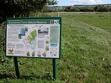 | Salmonsbury Meadows SSSI Salmonsbury Meadows (grid reference SP178213) is an 18-hectare (44-acre) biological and geological Site of Special Scientific Interest in Gloucestershire, notified in 1985. The site is owned and managed by the Gloucesterhire Wildlife Trust, and is part of its Greystones Farm nature reserve. |
 | Brassey SSSI Brassey (grid reference SP139223) is a 2.1-hectare (5.2-acre) biological Site of Special Scientific Interest in Gloucestershire. It is situated on the north side of the Windrush Valley, midway between Naunton and Upper Slaughter. The reserve comprises sloping, unimproved limestone pasture. |
 | Harford Railway Cutting Harford Railway Cutting (SP135218 to SP141215) is a geological Site of Special Scientific Interest in Gloucestershire, notified in 1974. The site is listed in the ‘Cotswold District’ Local Plan 2001-2011 (on line) as a Regionally Important Geological Site (RIGS) |
 | Bourton-on-the-Water model village Bourton-on-the-Water model village is one of the first model villages in the country. It was started in 1936 and completed in 1940. The model village contains around 100 buildings and is open to the public. |
Visit Upper Slaughter plaques
 2
2
plaques
here Upper Slaughter has 2 physical plaques in tourist plaque schemes for you to explore via Walkfo Upper Slaughter plaques audio map when visiting. Plaques like National Heritage’s “Blue Plaques” provide visual geo-markers to highlight points-of-interest at the places where they happened – and Walkfo’s AI has researched additional, deeper content when you visit Upper Slaughter using the app. Experience the history of a location when Walkfo local tourist guide app triggers audio close to each Upper Slaughter plaque. Explore Plaques & History has a complete list of Hartlepool’s plaques & Hartlepool history plaque map.


 Trying to encourage visitors to Upper Slaughter?