Welcome to Visit Trefeurig Places
The Walkfo guide to things to do & explore in Trefeurig
 Visit Trefeurig places using Walkfo for free guided tours of the best Trefeurig places to visit. A unique way to experience Trefeurig’s places, Walkfo allows you to explore Trefeurig as you would a museum or art gallery with audio guides.
Visiting Trefeurig Walkfo Preview
Trefeurig is situated 4 miles (6.4 km) north-east of Aberystwyth. It is a site of particular prehistoric, Roman, and Iron Age interest. In 2011 the local population was estimated at around 1,771 people. When you visit Trefeurig, Walkfo brings Trefeurig places to life as you travel by foot, bike, bus or car with a mobile phone & headphones.
Trefeurig Places Overview: History, Culture & Facts about Trefeurig
Visit Trefeurig – Walkfo’s stats for the places to visit
With 29 audio plaques & Trefeurig places for you to explore in the Trefeurig area, Walkfo is the world’s largest heritage & history digital plaque provider. The AI continually learns & refines facts about the best Trefeurig places to visit from travel & tourism authorities (like Wikipedia), converting history into an interactive audio experience.
Trefeurig history
The prehistoric period
There are traces of people living near Trefeurig since the New Stone Age. In 1986, archaeologists excavated a site on Gogerddan land in the triangular field between the A4159 and IBERS. There were also standing stones, round barrows, post-holes, Iron Age cremation remains, Early Medieval graves and cellular remains.
Contemporary
During the Norman invasion of northern Ceredigion in the early 12th century, Ystrad Peithyll Castle (Grid Ref SN623824) was built, and a wooden tower was placed on top of a mound surrounded with a ditch. During the Middle Ages, Trefeurig belonged to the Hundred of Penweddig.
Trefeurig geography / climate
Trefeurig is mostly open ground except for pine forests planted by Forestry Commission in 1930s. Three reservoirs and Pen-Cefn reservoir were built to supply water to the mines. There are five Sites of Special Scientific Interest (SSSI) at the community, including Cwmsymlog, Mwyngloddfa Cwmystwyth, and Llechweddhelyg.
Climate
The Gogerddan Weather Monitoring Station opened in 1953, near to the present day site of IBERS. It is located in Gogurddan, Wales, near the present-day site IBERS.
Why visit Trefeurig with Walkfo Travel Guide App?
 You can visit Trefeurig places with Walkfo Trefeurig to hear history at Trefeurig’s places whilst walking around using the free digital tour app. Walkfo Trefeurig has 29 places to visit in our interactive Trefeurig map, with amazing history, culture & travel facts you can explore the same way you would at a museum or art gallery with information audio headset. With Walkfo, you can travel by foot, bike or bus throughout Trefeurig, being in the moment, without digital distraction or limits to a specific walking route. Our historic audio walks, National Trust interactive audio experiences, digital tour guides for English Heritage locations are available at Trefeurig places, with a AI tour guide to help you get the best from a visit to Trefeurig & the surrounding areas.
“Curated content for millions of locations across the UK, with 29 audio facts unique to Trefeurig places in an interactive Trefeurig map you can explore.”
Walkfo: Visit Trefeurig Places Map
29 tourist, history, culture & geography spots
Trefeurig historic spots | Trefeurig tourist destinations | Trefeurig plaques | Trefeurig geographic features |
| Walkfo Trefeurig tourism map key: places to see & visit like National Trust sites, Blue Plaques, English Heritage locations & top tourist destinations in Trefeurig | |||
Best Trefeurig places to visit
Trefeurig has places to explore by foot, bike or bus. Below are a selection of the varied Trefeurig’s destinations you can visit with additional content available at the Walkfo Trefeurig’s information audio spots:
Hen Gaer
Hen Gaer is an Iron Age hillfort on a hill adjacent to Bow Street, Ceredigion, Wales. Other names of the hillfort are Broncastellan and Caer Shon.

Bow Street F.C.
Bow Street F.C. are based at Rhydypennau near Bow Street in Ceredigion, Wales, about 4+1/2 miles (7.2 km) north-east of Aberystwyth. The team are nicknamed the Magpies from the time when their strip was black and white stripes.
![]()
Penrhyncoch F.C.
Penrhyncoch Football Club is a semi-professional football club. The club was founded in 1965 and currently play in the Cymru North the second tier of Welsh football. They have played at their current home ground, Cae Baker.

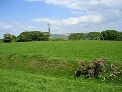
Ystrad Peithyll
Ystrad Peithyll is the remains of a small 12th-century motte-and-bailey castle. The castle was attacked and destroyed by followers of Gruffydd ap Rhys in the early 12th century.
Visit Trefeurig plaques
 0
0
plaques
here Trefeurig has 0 physical plaques in tourist plaque schemes for you to explore via Walkfo Trefeurig plaques audio map when visiting. Plaques like National Heritage’s “Blue Plaques” provide visual geo-markers to highlight points-of-interest at the places where they happened – and Walkfo’s AI has researched additional, deeper content when you visit Trefeurig using the app. Experience the history of a location when Walkfo local tourist guide app triggers audio close to each Trefeurig plaque. Currently No Physical Plaques.


 Trying to encourage visitors to Trefeurig?