Visit Torfaen Place – things to do & explore
 Visit Torfaen places on a day-trip, weekend away or holiday – and Walkfo becomes your personal digital tour guide to Torfaen things to do.
Visiting Torfaen Overview
Torfaen is a principal area with county borough status in the preserved county of Gwent, Wales . It is bordered by the county of Monmouthshire to the east, the city of Newport to the south, and the county boroughs of Caerphilly and Blaenau Gwent .
When you visit Torfaen, Torfaen history becomes available at the places you travel to by foot, bike, bus or car with a mobile phone & headphones.
Torfaen places overview by Walkfo
Visit to Torfaen stats
With 70 tourism audio plaques & places for you to explore in Torfaen, Walkfo is the world’s largest heritage & history digital plaque provider in the world. Our AI continually learns & refines content about the best Torfaen places to visit from online information authorities like Wikipedia for current & history, and converts it into an audio experience.
Torfaen etymology
Torfaen (meaning “breaker of stones”) is an old name for the river – today called Afon Lwyd (“grey river”) – which flows through Abersychan, Pontypool, and Cwmbran. The last three towns mentioned are a contiguous urban area.
When you visit Torfaen
You can visit Torfaen places and use Walkfo Torfaen to discover the history & things to do in Torfaen whilst walking with our free digital tour app. Walkfo Torfaen has 70 places on our Torfaen map with history, culture & travel facts that you explore the same way you would at a museum or art gallery with information audio headset. With Walkfo, you can travel by foot, bike or bus throughout Torfaen, being in the moment, without digital distraction or limits to a specific walking route – you choose where you want to go, when you want to go and Walkfo Torfaen will keep up.
–
With millions of places including tourist walks, Torfaen travel destinations, National Trust locations converted to audio experiences, our Torfaen places AI guide will help you get the best from your visit to Torfaen & the surrounding areas. The Torfaen places app for iPhone & Android delivers hidden history, interesting culture and amazing facts in interactive audio stories in response to where you walk at National Heritage sites, tourist attractions, historic locations or city streets, with no predefined walk map requirements.
“The Walkfo AI has curated content for millions of locations across the UK, with 70 audio facts unique to Torfaen places forming an interactive Torfaen map for you to explore.”
Walkfo’s Visit Torfaen Places Map
70 tourist, history, culture & geography spots
Torfaen historic spot | Torfaen tourist destination | Torfaen plaque | Torfaen geographic feature |
| Walkfo Torfaen tourism map key: places to see & visit like National Trust sites, Blue Plaques, English Heritage locations & top tourist destinations in Torfaen | |||
Best Torfaen places to visit
Torfaen has many places to explore by foot, bike or bus. Below are a selection of the varied Torfaen’s destinations you can visit with additional content available at the Walkfo Torfaen’s information audio spots:
 | Pontnewydd Pontnewydd is a community and an electoral ward of Torfaen County Borough Council. The community had a population of 4,954 in 2011. It should not be confused with Pontnewynydd in nearby Pontypool. |
 | Croesyceiliog A.F.C. The club was formed in 1964 as a youth team for pupils of Croesyceiliog School. It later entered a senior team in the Newport and District Football League. It reached the Welsh Football League for the first time in 2004. |
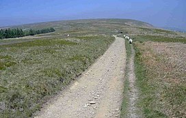 | Mynydd Twyn-glas Mynydd Twyn-glas is a sprawling 472-metre-high mountain in South Wales. It lies southwest of Pontypool, west of Cwmbran and east of Newbridge. The thickly afforested northern slopes of the hill drop down steeply into Cwm y Glyn. |
| Blaenavon Blaenavon is both a town and a community in Torfaen county borough, Wales. It is within the boundaries of the historic county of Monmouthshire and the preserved county of Gwent. Parts of the town and surrounding country are inscribed as a World Heritage Site by UNESCO. |
 | County Hall, Cwmbran County Hall was a municipal facility on Turnpike Road in Croesyceiliog in Cwmbran in Wales. It was the headquarters of Gwent County Council from 1978 to 1996. |
 | St Michael’s Church, Llantarnam The Parish Church of St Michael’s & All Angels is a Grade II* listed parish church in Llantarnam, near Cwmbran, Torfaen, Wales. |
 | Talywain Talywain is situated in Garndiffaith, Abersychan and Pentwyn in Torfaen in south east Wales. It is within the historic boundaries of Monmouthshire. |
| Pentrepiod Halt railway station (Monmouthshire) Pentrepiod Halt, Monmouthshire is a former railway station that was located 2 miles north of Pontypool. It was located approximately 2 miles. north of. Pontypools in the area. |
 | Shell Grotto, Pontypool Shell Grotto – (Welsh: Groto Cregyn) – (sometimes called the Shell Hermitage) – is a Grade II* listed, cylindrical, slate roofed shell grotto decorated with shells and animal bones on the interior. It stands on a prominent ridge 700 ft (213 m) above sea level in Pontypool Park, Torfaen in south Wales. |
| Cwmynyscoy Cwmynyscoy is a suburb of Pontypool town in the district of the County Borough of Torfaen, south east Wales. |
Visit Torfaen plaques
 2
2
plaques
here Torfaen has 2 physical plaques within tourist plaque schemes for you to explore via Walkfo Torfaen plaques when visiting. Plaque schemes such as National Heritage’s “Blue Plaques” provide visual geo-markers to highlight points-of-interest at the places where they happened. Where a plaque is available, Walkfo AI has done research to provide additional, deeper content when you visit Torfaen using the app. Experience hidden history & stories at each location as the Walkfo local tourist guide app uses trigger audio close to each Torfaen plaque. Explore Torfaen Plaques & History has a complete list of Hartlepool’s plaques & Hartlepool history plaque map.


 Trying to encourage visitors to Torfaen?