Welcome to Visit Thormanby Places
The Walkfo guide to things to do & explore in Thormanby
 Visit Thormanby places using Walkfo for free guided tours of the best Thormanby places to visit. A unique way to experience Thormanby’s places, Walkfo allows you to explore Thormanby as you would a museum or art gallery with audio guides.
Visiting Thormanby Walkfo Preview
Thormanby is a village and civil parish in Hambleton District of North Yorkshire. It lies on the A19 between Easingwold and Thirsk and about 14 miles (23 km) south east of Northallerton. When you visit Thormanby, Walkfo brings Thormanby places to life as you travel by foot, bike, bus or car with a mobile phone & headphones.
Thormanby Places Overview: History, Culture & Facts about Thormanby
Visit Thormanby – Walkfo’s stats for the places to visit
With 9 audio plaques & Thormanby places for you to explore in the Thormanby area, Walkfo is the world’s largest heritage & history digital plaque provider. The AI continually learns & refines facts about the best Thormanby places to visit from travel & tourism authorities (like Wikipedia), converting history into an interactive audio experience.
Thormanby history
Thormanby is derived from the Old Norse personal name of Thormothr / Þórmóðr (Tormod in modern Norwegian) The name means “Thor’s gift” (i.e. “mind” and “courage”) The village is mentioned twice in the Domesday Book of 1086 as “Tormozbi” in the Yarlestre wapentake.
Thormanby landmarks
The village church is dedicated to St Mary Magdalene and is a Grade II* listed building. It was built in the 12th century and has been subject to frequent changes up to 1955. Near the Rectory is a small redundant Wesleyan chapel, built in 1875, which is now a private house.
Thormanby geography / climate
The village lies at and elevation between 148 feet (45 m) and 180 feet (55 m) The nearest settlements are the hamlet of Birdforth 0.7 miles (1.1 km) to the north. The Thirsk and Malton branch of the North Eastern Railway passes through the parish.
Topography
The surface elevation is relatively consistent, varying in height from 103 feet (31.4 m) to 175 feet (53.3 m) above Ordnance Survey data. In the south there is an area of low-lying carr (landform) – Sun Beck, Birdforth Beck and Ings Beck, which are part of the tributary system of the River Swale, drain the land.
Why visit Thormanby with Walkfo Travel Guide App?
 You can visit Thormanby places with Walkfo Thormanby to hear history at Thormanby’s places whilst walking around using the free digital tour app. Walkfo Thormanby has 9 places to visit in our interactive Thormanby map, with amazing history, culture & travel facts you can explore the same way you would at a museum or art gallery with information audio headset. With Walkfo, you can travel by foot, bike or bus throughout Thormanby, being in the moment, without digital distraction or limits to a specific walking route. Our historic audio walks, National Trust interactive audio experiences, digital tour guides for English Heritage locations are available at Thormanby places, with a AI tour guide to help you get the best from a visit to Thormanby & the surrounding areas.
“Curated content for millions of locations across the UK, with 9 audio facts unique to Thormanby places in an interactive Thormanby map you can explore.”
Walkfo: Visit Thormanby Places Map
9 tourist, history, culture & geography spots
Thormanby historic spots | Thormanby tourist destinations | Thormanby plaques | Thormanby geographic features |
| Walkfo Thormanby tourism map key: places to see & visit like National Trust sites, Blue Plaques, English Heritage locations & top tourist destinations in Thormanby | |||
Best Thormanby places to visit
Thormanby has places to explore by foot, bike or bus. Below are a selection of the varied Thormanby’s destinations you can visit with additional content available at the Walkfo Thormanby’s information audio spots:

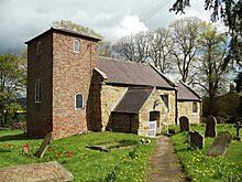
St Mary’s Church, Birdforth
St Mary’s Church, or Birdforth Old Chapel, is a former Anglican church in the village of Birdforth, North Yorkshire. It is recorded in the National Heritage List for England as a designated Grade II listed building.
Visit Thormanby plaques
 0
0
plaques
here Thormanby has 0 physical plaques in tourist plaque schemes for you to explore via Walkfo Thormanby plaques audio map when visiting. Plaques like National Heritage’s “Blue Plaques” provide visual geo-markers to highlight points-of-interest at the places where they happened – and Walkfo’s AI has researched additional, deeper content when you visit Thormanby using the app. Experience the history of a location when Walkfo local tourist guide app triggers audio close to each Thormanby plaque. Currently No Physical Plaques.


 Trying to encourage visitors to Thormanby?