Welcome to Visit Tanygrisiau Places
The Walkfo guide to things to do & explore in Tanygrisiau
 Visit Tanygrisiau places using Walkfo for free guided tours of the best Tanygrisiau places to visit. A unique way to experience Tanygrisiau’s places, Walkfo allows you to explore Tanygrisiau as you would a museum or art gallery with audio guides.
Visiting Tanygrisiau Walkfo Preview
Tanygrisiau is found along the southern side of the Moelwyn mountain range and dates to around 1750. It is located between 650 feet (200 m) and 750 feet (230 m) above sea level. The village itself has a population of around 350. When you visit Tanygrisiau, Walkfo brings Tanygrisiau places to life as you travel by foot, bike, bus or car with a mobile phone & headphones.
Tanygrisiau Places Overview: History, Culture & Facts about Tanygrisiau
Visit Tanygrisiau – Walkfo’s stats for the places to visit
With 40 audio plaques & Tanygrisiau places for you to explore in the Tanygrisiau area, Walkfo is the world’s largest heritage & history digital plaque provider. The AI continually learns & refines facts about the best Tanygrisiau places to visit from travel & tourism authorities (like Wikipedia), converting history into an interactive audio experience.
Tanygrisiau geography / climate
The Moelwyns protect the village from much of the wind from northerly gales in the winter. However rainfall in the upper end of the Ffestiniog valley can be very high all year around.
Why visit Tanygrisiau with Walkfo Travel Guide App?
 You can visit Tanygrisiau places with Walkfo Tanygrisiau to hear history at Tanygrisiau’s places whilst walking around using the free digital tour app. Walkfo Tanygrisiau has 40 places to visit in our interactive Tanygrisiau map, with amazing history, culture & travel facts you can explore the same way you would at a museum or art gallery with information audio headset. With Walkfo, you can travel by foot, bike or bus throughout Tanygrisiau, being in the moment, without digital distraction or limits to a specific walking route. Our historic audio walks, National Trust interactive audio experiences, digital tour guides for English Heritage locations are available at Tanygrisiau places, with a AI tour guide to help you get the best from a visit to Tanygrisiau & the surrounding areas.
“Curated content for millions of locations across the UK, with 40 audio facts unique to Tanygrisiau places in an interactive Tanygrisiau map you can explore.”
Walkfo: Visit Tanygrisiau Places Map
40 tourist, history, culture & geography spots
Tanygrisiau historic spots | Tanygrisiau tourist destinations | Tanygrisiau plaques | Tanygrisiau geographic features |
| Walkfo Tanygrisiau tourism map key: places to see & visit like National Trust sites, Blue Plaques, English Heritage locations & top tourist destinations in Tanygrisiau | |||
Best Tanygrisiau places to visit
Tanygrisiau has places to explore by foot, bike or bus. Below are a selection of the varied Tanygrisiau’s destinations you can visit with additional content available at the Walkfo Tanygrisiau’s information audio spots:
 | Moelwyn Mawr Moelwyn Mawr is a mountain in Snowdonia, North Wales. Its summit overlooks the Vale of Ffestiniog and has views in all directions. |
 | Glynllifon Street railway station Glynllifon Street railway station was a temporary northern terminus station of the Festiniog and Blaenau Railway (F&BR) sited between the street of the same name and Cwmbowydd Road. It was never named. |
 | Ffestiniog Memorial Hospital Ffestiniog Memorial Hospital is a health facility in Blaenau, Gwynedd, Wales. It is managed by the Betsi Cadwaladr University Health Board. |
 | Car gwyllt The car gwyllt is a Welsh invention used by quarrymen to ride downhill on the steep inclined planes of a slate quarry. The invention was invented by Welsh quarrymen in the 1930s. |
 | Blaenau Ffestiniog Amateur F.C. Blaenau Ffestiniog Amateur Football Club are a Welsh football club. Founded in 1883, they are given the nickname “The Quarrymen” due to the quarry history around the town. The Quarry Men play their home games at Cae Clyd. |
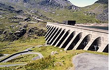 | Ffestiniog Power Station The Ffestiniog Power Station is a 360-megawatt (480,000 hp) pumped-storage hydroelectricity scheme. The station, commissioned in 1963, was the first major pumped storage system in the UK. The scheme has the capacity to power the whole of North Wales for several hours. |
 | Conglog quarry Conglog quarry was a small enterprise situated to the north-west of Tanygrisiau, near Blaenau Ffestiniog in Wales. It was overshadowed by the much bigger Rhosydd quarry a little further to the west. |
Visit Tanygrisiau plaques
 0
0
plaques
here Tanygrisiau has 0 physical plaques in tourist plaque schemes for you to explore via Walkfo Tanygrisiau plaques audio map when visiting. Plaques like National Heritage’s “Blue Plaques” provide visual geo-markers to highlight points-of-interest at the places where they happened – and Walkfo’s AI has researched additional, deeper content when you visit Tanygrisiau using the app. Experience the history of a location when Walkfo local tourist guide app triggers audio close to each Tanygrisiau plaque. Currently No Physical Plaques.


 Trying to encourage visitors to Tanygrisiau?