Welcome to Visit Swindon Places
The Walkfo guide to things to do & explore in Swindon
 Visit Swindon places using Walkfo for free guided tours of the best Swindon places to visit. A unique way to experience Swindon’s places, Walkfo allows you to explore Swindon as you would a museum or art gallery with audio guides.
Visiting Swindon Walkfo Preview
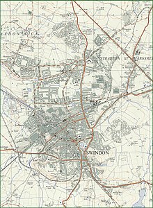
Swindon is a large town in Wiltshire, South West England . It is 71 miles (114 km) west of London . The town is home to the English Heritage National Monument Record Centre and the headquarters of the National Trust . When you visit Swindon, Walkfo brings Swindon places to life as you travel by foot, bike, bus or car with a mobile phone & headphones.
Swindon Places Overview: History, Culture & Facts about Swindon
Visit Swindon – Walkfo’s stats for the places to visit
With 51 audio plaques & Swindon places for you to explore in the Swindon area, Walkfo is the world’s largest heritage & history digital plaque provider. The AI continually learns & refines facts about the best Swindon places to visit from travel & tourism authorities (like Wikipedia), converting history into an interactive audio experience.
Swindon history
Early history
Swindon is recorded in the 1086 Domesday Book as a manor in the hundred of Blagrove, Wiltshire . It was one of the larger manors, recorded as having 27 households and a rent value of £10 14s . The Goddard family were lord of the manor from the 16th century for many generations, living at The Lawn .
Railway town

Isambard Kingdom Brunel’s Swindon Works was built for the repair and maintenance of locomotives on the Great Western Railway . The GWR built a small railway village to house some of its workers . During the first half of the 20th century, the railway works was the town’s largest employer and one of the biggest in the country . The Steam Railway Museum and English Heritage occupy part of the old works .
Modern period
David Murray John, Swindon’s town clerk from 1938 to 1974, is seen as a pioneering figure in the post-war regeneration . The town now has all the features of a successful urban/rural council in the Outer southeast zone . The average household income is among the highest in the country .
Swindon geography / climate
Swindon is 35 miles (56 km) west-northwest of Reading and the same distance east-northeast of Bristol ‘as the crow flies’ The Old Town stands on a hill of Purbeck and Portland stone; this was quarried from Roman times until the 1950s. The landscape is dominated by the chalk hills of the Wiltshire Downs to the south and east. The River Ray rises at Wroughton and forms much of the borough’s western boundary.
Climate
Swindon has an oceanic climate (Cfb in the Köppen climate classification) with cool winters and warm summers . The nearest official weather station is RAF Lyneham, about 10 miles (16 km) west southwest of town centre . Annual rainfall averages slightly under 720 mm (28 in) per year, with 123 days reporting over 1 mm of rain .
Why visit Swindon with Walkfo Travel Guide App?
 You can visit Swindon places with Walkfo Swindon to hear history at Swindon’s places whilst walking around using the free digital tour app. Walkfo Swindon has 51 places to visit in our interactive Swindon map, with amazing history, culture & travel facts you can explore the same way you would at a museum or art gallery with information audio headset. With Walkfo, you can travel by foot, bike or bus throughout Swindon, being in the moment, without digital distraction or limits to a specific walking route. Our historic audio walks, National Trust interactive audio experiences, digital tour guides for English Heritage locations are available at Swindon places, with a AI tour guide to help you get the best from a visit to Swindon & the surrounding areas.
“Curated content for millions of locations across the UK, with 51 audio facts unique to Swindon places in an interactive Swindon map you can explore.”
Walkfo: Visit Swindon Places Map
51 tourist, history, culture & geography spots
Swindon historic spots | Swindon tourist destinations | Swindon plaques | Swindon geographic features |
| Walkfo Swindon tourism map key: places to see & visit like National Trust sites, Blue Plaques, English Heritage locations & top tourist destinations in Swindon | |||
Best Swindon places to visit
Swindon has places to explore by foot, bike or bus. Below are a selection of the varied Swindon’s destinations you can visit with additional content available at the Walkfo Swindon’s information audio spots:

Holy Rood Church, Swindon
Holy Rood Church is a Roman Catholic parish church in Swindon, Wiltshire. It was founded in 1851 as a chapel and was rebuilt in 1905. It is situated on the corner of Groundwell Road and Lincoln Street in the centre of the town.

Swindon Town Hall
Swindon Town Hall is a Grade II listed building. It was built in to be a centrepiece of New Swindonia. It is currently used by Swindons Dance, a National Dance Agency.
![]()
Link Centre
The Link Centre is owned by Swindon Borough Council and operated by Greenwich Leisure under the brand “Better” It is best known for its national-sized ice rink which houses an English Premier Ice Hockey League team.

Renault Centre
The Renault Centre (or the Renault Distribution Centre) is a high tech building in Swindon commissioned by the French car company Renault for their UK operations. Designed by the British architect Norman Foster of Foster Associates, it opened in 1982 and Renault moved out in 2001.

Rodbourne
Rodbourne is a suburb of Swindon in Wiltshire. It is north of the town centre and about 0.9 miles (1.4 km) northwest of railway station.

St Augustine’s Church, Even Swindon
The Church of St. Augustine is an Anglican parish church in Even Swindon (also known locally as Rodbourne) The church was built to serve the spiritual needs of people moving to the town because of the Great Western Railway Works. The church is in the Diocese of Bristol and the province of Canterbury.

Old Town Hall, Swindon
The Old Town Hall is a former municipal building of 1854 in the High Street, Swindon, Wiltshire, England. It is a Grade II listed building.

Swindon Arts Centre
Swindon Arts Centre is a 212-seat entertainment venue. It opened in 1956 and is situated in the heart of the Old Town area. The venue hosts a varied programme of entertainment all year round.

Fir Clump Stone Circle
Fir Clump Stone Circle was a double concentric circle consisting of sarsen megaliths. The outer ring measured 107 metres (351 ft) by 86.5 metres (284 ft) in diameter. It was one of at least seven stone circles that are known to have been erected in the area south of Swindon.

Coate Water Country Park
Coate Water is a country park situated 5 km (3.1 mi) to the southeast of central Swindon, England. It takes its name from a reservoir originally built to provide water for the Wilts & Berks Canal. The reservoir formed a 70-acre (280,000 m) lake, built in 1822 by diverting the River Cole. Swimming in the lake has been prohibited since 1958.
Visit Swindon plaques
 5
5
plaques
here Swindon has 5 physical plaques in tourist plaque schemes for you to explore via Walkfo Swindon plaques audio map when visiting. Plaques like National Heritage’s “Blue Plaques” provide visual geo-markers to highlight points-of-interest at the places where they happened – and Walkfo’s AI has researched additional, deeper content when you visit Swindon using the app. Experience the history of a location when Walkfo local tourist guide app triggers audio close to each Swindon plaque. Explore Plaques & History has a complete list of Hartlepool’s plaques & Hartlepool history plaque map.


 Trying to encourage visitors to Swindon?