Welcome to Visit Sutherland Places
The Walkfo guide to things to do & explore in Sutherland
 Visit Sutherland places using Walkfo for free guided tours of the best Sutherland places to visit. A unique way to experience Sutherland’s places, Walkfo allows you to explore Sutherland as you would a museum or art gallery with audio guides.
Visiting Sutherland Walkfo Preview
Sutherland (Scottish Gaelic: Cataibh) is a historic county, registration county and lieutenancy area in the Highlands of Scotland. It borders Caithness and Moray Firth to the east, Ross-shire to the south and the Atlantic to the north and west. The name Sutherland dates from the era of Norwegian Viking rule and settlement over much of the Highlands and Islands. When you visit Sutherland, Walkfo brings Sutherland places to life as you travel by foot, bike, bus or car with a mobile phone & headphones.
Sutherland Places Overview: History, Culture & Facts about Sutherland
Visit Sutherland – Walkfo’s stats for the places to visit
With 1 audio plaques & Sutherland places for you to explore in the Sutherland area, Walkfo is the world’s largest heritage & history digital plaque provider. The AI continually learns & refines facts about the best Sutherland places to visit from travel & tourism authorities (like Wikipedia), converting history into an interactive audio experience.
Sutherland geography / climate
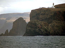
The inland landscape is rugged and very sparsely populated. Despite being Scotland’s fifth-largest county in terms of area, it has a smaller population than a medium-size Lowland Scottish town. It stretches from the Atlantic in the west, up to the Pentland Firth and across to the North Sea in the east. The sea-coasts boast very high cliffs and deep fjords in the east and north, ragged inlets on the west and sandy beaches in the north. The east coast contains the sea lochs of Loch Fleet and Dornoch Firth. The remote far northwest point of Sutherland, Cape Wrath, is also the most northwesterly point in Scotland. Several peninsulas can be found along the north and west coasts, most notably Strathy Point, A’ Mhòine, Durness/Faraid Head (the latter two formed by the Kyle of Durness, Loch Eriboll and the Kyle of Tongue), Ceathramh Garbh (formed by Loch Laxford and Loch Inchard), and Stoer Head. The county has many fine beaches, a remote example being Sandwood Bay, which can only be reached by foot along a rough track. The number of visiting tourists is, naturally, minimal. Sutherland has many rugged mountains such as Ben Hope, the most northerly Munro, and Ben More Assynt, the tallest peak in the county at 998 m (3,274 ft). The western part comprises Torridonian sandstone underlain by Lewisian gneiss. The spectacular scenery has been created by denudation to form isolated sandstone peaks such as Foinaven, Arkle, Cùl Mòr and Suilven. Such mountains are attractive for hill walking and scrambling, despite their remote location. Together with similar peaks to the south in Wester Ross, such as Stac Pollaidh, they have a unique structure with great scope for exploration. On the other hand, care is needed when bad weather occurs owing to their isolation and the risks of injury. There are a large number of inland lochs in the county. The most prominent being: Loch Veyatie Loch Urigill Loch Dionard Fionn Loch Càm Loch Loch Assynt Loch an Gainimh Loch Poll Loch Beannach Loch an Leothaid Loch an Leothaid Bhuain Loch Stack Loch na Tuadh Loch na Claise Càrnaich Sandwood Loch Loch Ailsh Loch na Claise Mòire Loch Fiag Loch Merkland Loch Shin Glas-loch Mòr Loch Meadie Loch an Deerie Loch a’ Ghorm-choire Loch Coire-na Saidhe Duibhe Loch Airigh na Beinne Loch Meadaidh Loch na Seilg Loch Hope Loch Loyal Loch Craggie Loch Syre Loch Truderscaig Loch Strathy Loch Cròcach Loch Druim à Chliabhain Loch Arichlinie Loch an Ruathair Loch nan Clach Loch Mòr na Caorach Loch Horn Loch Brora Loch Buidhe Loch Migdale Gorm-loch Mòr Loch Ascaig Loch Naver Loch a’ Bhealaich Loch Choire Loch Rimsdale Loch Truderscaig Loch Nan Clar Loch Badanloch Loch an Altan Fheàrna Loch na Seilge Loch Borralan Loch Urigill Loch Dionard Fionn Loch Càm Loch Loch Assynt Loch an Gainimh Loch Poll Loch Beannach Loch an Leothaid Loch an Leothaid Bhuain Loch Stack Loch na Tuadh Loch na Claise Càrnaich Sandwood Loch Loch Ailsh Loch na Claise Mòire Loch Fiag Loch Merkland Loch Shin Glas-loch Mòr Loch Meadie Loch an Deerie Loch a’ Ghorm-choire Loch Coire-na Saidhe Duibhe Loch Airigh na Beinne Loch Meadaidh Loch na Seilg Loch Hope Loch Loyal Loch Craggie Loch Syre Loch Truderscaig Loch Strathy Loch Cròcach Loch Druim à Chliabhain Loch Arichlinie Loch an Ruathair Loch nan Clach Loch Mòr na Caorach Loch Horn Loch Brora Loch Buidhe Loch Migdale Gorm-loch Mòr Loch Ascaig Loch Naver Loch a’ Bhealaich Loch Choire Loch Rimsdale Loch Truderscaig Loch Nan Clar Loch Badanloch Loch an Altan Fheàrna Loch na Seilge Loch Borralan Owing to its isolation from the rest of the country, Sutherland was reputedly the last haunt of the native wolf, the last survivor being shot in the 18th century. However, other wildlife has survived, including the golden eagle, sea eagle and pine marten amongst other species which are very rare in the rest of the country. There are pockets of the native Scots Pine, remnants of the original Caledonian Forest. The importance of the county’s scenery is recognised by the fact that four of Scotland’s forty national scenic areas (NSAs) are located here. The purpose of the NSA designation is to identify areas of exceptional scenery and to ensure its protection from inappropriate development. The areas protected by the designation are considered to represent the type of scenic beauty “popularly associated with Scotland and for which it is renowned”. The four NSAs within Sutherland are: The Assynt-Coigach NSA has many distinctively shaped mountains, including Quinag, Canisp, Suilven, Cùl Mòr, Stac Pollaidh and Ben More Assynt, that rise steeply from the surrounding “cnoc and lochan” scenery. These can often appear higher than their actual height would indicate due to their steep sides and the contrast with the moorland from which they rise. Assynt lies within Sutherland, whilst Coigach lies within Ross and Cromarty. The Dornoch Firth NSA also straddles the boundary between Sutherland and Ross and Cromarty, and covers a variety of landscapes surrounding the narrow and sinuous firth. The Kyle of Tongue NSA covers the mountains of Ben Hope and Ben Loyal, as well as woodlands and crofting settlements on the shoreline of the kyle itself. The North West Sutherland NSA covers the mountains of Foinaven, Arkle and Ben Stack as well as the coastal scenery surrounding Loch Laxford and Handa Island.
Why visit Sutherland with Walkfo Travel Guide App?
 You can visit Sutherland places with Walkfo Sutherland to hear history at Sutherland’s places whilst walking around using the free digital tour app. Walkfo Sutherland has 1 places to visit in our interactive Sutherland map, with amazing history, culture & travel facts you can explore the same way you would at a museum or art gallery with information audio headset. With Walkfo, you can travel by foot, bike or bus throughout Sutherland, being in the moment, without digital distraction or limits to a specific walking route. Our historic audio walks, National Trust interactive audio experiences, digital tour guides for English Heritage locations are available at Sutherland places, with a AI tour guide to help you get the best from a visit to Sutherland & the surrounding areas.
“Curated content for millions of locations across the UK, with 1 audio facts unique to Sutherland places in an interactive Sutherland map you can explore.”
Walkfo: Visit Sutherland Places Map
1 tourist, history, culture & geography spots
Sutherland historic spots | Sutherland tourist destinations | Sutherland plaques | Sutherland geographic features |
| Walkfo Sutherland tourism map key: places to see & visit like National Trust sites, Blue Plaques, English Heritage locations & top tourist destinations in Sutherland | |||
Best Sutherland places to visit
Sutherland has places to explore by foot, bike or bus. Below are a selection of the varied Sutherland’s destinations you can visit with additional content available at the Walkfo Sutherland’s information audio spots:
Visit Sutherland plaques
 0
0
plaques
here Sutherland has 0 physical plaques in tourist plaque schemes for you to explore via Walkfo Sutherland plaques audio map when visiting. Plaques like National Heritage’s “Blue Plaques” provide visual geo-markers to highlight points-of-interest at the places where they happened – and Walkfo’s AI has researched additional, deeper content when you visit Sutherland using the app. Experience the history of a location when Walkfo local tourist guide app triggers audio close to each Sutherland plaque. Currently No Physical Plaques.


 Trying to encourage visitors to Sutherland?