Welcome to Visit Stretham Places
The Walkfo guide to things to do & explore in Stretham
 Visit Stretham places using Walkfo for free guided tours of the best Stretham places to visit. A unique way to experience Stretham’s places, Walkfo allows you to explore Stretham as you would a museum or art gallery with audio guides.
Visiting Stretham Walkfo Preview
Stretham is 4 miles (6 km) south-south-west of Ely in Cambridgeshire. Main attraction is steam-powered pump used to drain the fens. The pump is still in use today although converted to electric power. When you visit Stretham, Walkfo brings Stretham places to life as you travel by foot, bike, bus or car with a mobile phone & headphones.
Stretham Places Overview: History, Culture & Facts about Stretham
Visit Stretham – Walkfo’s stats for the places to visit
With 19 audio plaques & Stretham places for you to explore in the Stretham area, Walkfo is the world’s largest heritage & history digital plaque provider. The AI continually learns & refines facts about the best Stretham places to visit from travel & tourism authorities (like Wikipedia), converting history into an interactive audio experience.
Stretham history

Stretham means homestead or village on the road (possibly Roman); Latin strata for paved road or old English ystrad for road plus old English ham for village. Bronze Age hoard consisting of gold jewellery including a torque, bracelet, six ribbed-rings as well as a bronze rapier was discovered in Granta Fen near Strethams in 1850.
Stretham geography / climate
Geology
The village is on an east–west running boulder clay (middle-Pleistocene till) ridge. It sits on a belt of mainly Jurassic Kimmerigian clays running south-west from The Wash. The highest point in the village is 53 feet (16 m) above sea-level. Highest point in Cambridgeshire is at Ely, three-mile (6 km) north-north-east.
Boundaries
The River Great Ouse forms the south-west border of the village. The eastern border is formed by the River Cam. The A10 road cuts the village in half running north-east on towards Little Thetford then Ely.
Climate
Cambridgeshire is one of the driest counties in the British Isles. The average annual rainfall of 24 inches (600 mm) makes it driest in the UK.
Why visit Stretham with Walkfo Travel Guide App?
 You can visit Stretham places with Walkfo Stretham to hear history at Stretham’s places whilst walking around using the free digital tour app. Walkfo Stretham has 19 places to visit in our interactive Stretham map, with amazing history, culture & travel facts you can explore the same way you would at a museum or art gallery with information audio headset. With Walkfo, you can travel by foot, bike or bus throughout Stretham, being in the moment, without digital distraction or limits to a specific walking route. Our historic audio walks, National Trust interactive audio experiences, digital tour guides for English Heritage locations are available at Stretham places, with a AI tour guide to help you get the best from a visit to Stretham & the surrounding areas.
“Curated content for millions of locations across the UK, with 19 audio facts unique to Stretham places in an interactive Stretham map you can explore.”
Walkfo: Visit Stretham Places Map
19 tourist, history, culture & geography spots
Stretham historic spots | Stretham tourist destinations | Stretham plaques | Stretham geographic features |
| Walkfo Stretham tourism map key: places to see & visit like National Trust sites, Blue Plaques, English Heritage locations & top tourist destinations in Stretham | |||
Best Stretham places to visit
Stretham has places to explore by foot, bike or bus. Below are a selection of the varied Stretham’s destinations you can visit with additional content available at the Walkfo Stretham’s information audio spots:
 | Mereham East Cambridgeshire District Council turned down initial planning application, though the developers subsequently appealed. Planning Inspector, Richard Ogier, made his report in April 2008, and in August 2008 the Secretary of State for Communities announced that permission for the development had been refused. |
 | Cantabrigian Rowing Club Cantabrigian Rowing Club, known as Cantabs, is a rowing and sculling club in Cambridge, UK. The club is a ‘town’ (or CRA) rowing club in the city of Cambridge. |
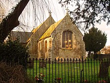 | St George’s Church, Little Thetford St George’s Church, Little Thetford, Cambridgeshire, is an Anglican church. It was built in the 18th century. |
Visit Stretham plaques
 0
0
plaques
here Stretham has 0 physical plaques in tourist plaque schemes for you to explore via Walkfo Stretham plaques audio map when visiting. Plaques like National Heritage’s “Blue Plaques” provide visual geo-markers to highlight points-of-interest at the places where they happened – and Walkfo’s AI has researched additional, deeper content when you visit Stretham using the app. Experience the history of a location when Walkfo local tourist guide app triggers audio close to each Stretham plaque. Currently No Physical Plaques.


 Trying to encourage visitors to Stretham?