Welcome to Visit Streat Places
The Walkfo guide to things to do & explore in Streat
 Visit Streat places using Walkfo for free guided tours of the best Streat places to visit. A unique way to experience Streat’s places, Walkfo allows you to explore Streat as you would a museum or art gallery with audio guides.
Visiting Streat Walkfo Preview
Streat is 3 miles (4.8 km) south-east of Burgess Hill and 5 miles (8.0 km) west of Lewes, within the South Downs National Park. The 11th-century parish church has no dedication; the ecclesiastical parish is joined with Westmeston. When you visit Streat, Walkfo brings Streat places to life as you travel by foot, bike, bus or car with a mobile phone & headphones.
Streat Places Overview: History, Culture & Facts about Streat
Visit Streat – Walkfo’s stats for the places to visit
With 17 audio plaques & Streat places for you to explore in the Streat area, Walkfo is the world’s largest heritage & history digital plaque provider. The AI continually learns & refines facts about the best Streat places to visit from travel & tourism authorities (like Wikipedia), converting history into an interactive audio experience.
Streat history
Archaeologists have suggested that forest clearances may have started earlier on the thinner soils of the Lower Greensand in places such as Streat, where flint tools from the period can be found in abundance. Medieval Streat had much common land for people to graze their animals, make hay and garner other resources. A quarter of the common was ploughed up in 1258 and the rest of the main commons of Streat were enclosed.
Streat landmarks
Clayton to Offham Escarpment is a Site of Special Scientific Interest. It stretches from Hassocks in the west and passes through many parishes including Streat, to Lewes in the east. The site is of biological importance due to its rare chalk grassland habitat.
Why visit Streat with Walkfo Travel Guide App?
 You can visit Streat places with Walkfo Streat to hear history at Streat’s places whilst walking around using the free digital tour app. Walkfo Streat has 17 places to visit in our interactive Streat map, with amazing history, culture & travel facts you can explore the same way you would at a museum or art gallery with information audio headset. With Walkfo, you can travel by foot, bike or bus throughout Streat, being in the moment, without digital distraction or limits to a specific walking route. Our historic audio walks, National Trust interactive audio experiences, digital tour guides for English Heritage locations are available at Streat places, with a AI tour guide to help you get the best from a visit to Streat & the surrounding areas.
“Curated content for millions of locations across the UK, with 17 audio facts unique to Streat places in an interactive Streat map you can explore.”
Walkfo: Visit Streat Places Map
17 tourist, history, culture & geography spots
Streat historic spots | Streat tourist destinations | Streat plaques | Streat geographic features |
| Walkfo Streat tourism map key: places to see & visit like National Trust sites, Blue Plaques, English Heritage locations & top tourist destinations in Streat | |||
Best Streat places to visit
Streat has places to explore by foot, bike or bus. Below are a selection of the varied Streat’s destinations you can visit with additional content available at the Walkfo Streat’s information audio spots:
 | Ditchling Common Ditchling Common is a 66.5-hectare (164-acre) biological Site of Special Scientific Interest in East Sussex. It is a country park owned and managed by East Sussex County Council. |
 | St Cosmas and St Damian Church, Keymer St Cosmas and St Damian Church is an Anglican church in Keymer, in the Mid Sussex district of West Sussex. Rebuilt in 1866 in a style similar to the Saxon building it replaced, it is the parish church of Keymer and now lies within a combined parish serving three villages in Mid Sussex. |
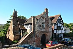 | Wings Place Wings Place, formerly Ditchling Garden Manor, also known as Anne of Cleves House, is a Grade I country house in East Sussex. It is a Tudor house said to be one of the best examples in the country. |
 | Clayton to Offham Escarpment Clayton to Offham Escarpment is a 422.5-hectare (1,044-acre) linear biological Site of Special Scientific Interest. It runs from Clayton in West Sussex to Lewes in East Sussex. Ownership and management is divided between over fifteen landowners and farmers. |
 | Oldland Mill, Keymer Oldland Windmill is an 18th-century post mill situated in Keymer, West Sussex, England. It is situated in the village of Keymer in the West Sussex. |
 | Ditchling Unitarian Chapel Ditchling Unitarian Chapel is a Unitarian chapel. It was built in 1740 after a congregation of General Baptists began to meet in the village. The congregation moved towards Unitarian views in the mid-18th century. People associated with the chapel include William Hale White (the author “Mark Rutherford”) |
Visit Streat plaques
 2
2
plaques
here Streat has 2 physical plaques in tourist plaque schemes for you to explore via Walkfo Streat plaques audio map when visiting. Plaques like National Heritage’s “Blue Plaques” provide visual geo-markers to highlight points-of-interest at the places where they happened – and Walkfo’s AI has researched additional, deeper content when you visit Streat using the app. Experience the history of a location when Walkfo local tourist guide app triggers audio close to each Streat plaque. Explore Plaques & History has a complete list of Hartlepool’s plaques & Hartlepool history plaque map.


 Trying to encourage visitors to Streat?