Welcome to Visit Storrington Places
The Walkfo guide to things to do & explore in Storrington
 Visit Storrington places using Walkfo for free guided tours of the best Storrington places to visit. A unique way to experience Storrington’s places, Walkfo allows you to explore Storrington as you would a museum or art gallery with audio guides.
Visiting Storrington Walkfo Preview
Storrington lies at the foot of the north side of the South Downs. As of 2006 it has a population of around 4,600. It has one main shopping street (High Street) The A283 road runs directly through the village. When you visit Storrington, Walkfo brings Storrington places to life as you travel by foot, bike, bus or car with a mobile phone & headphones.
Storrington Places Overview: History, Culture & Facts about Storrington
Visit Storrington – Walkfo’s stats for the places to visit
With 29 audio plaques & Storrington places for you to explore in the Storrington area, Walkfo is the world’s largest heritage & history digital plaque provider. The AI continually learns & refines facts about the best Storrington places to visit from travel & tourism authorities (like Wikipedia), converting history into an interactive audio experience.
Storrington history
Storrington is listed in the Domesday Book as ‘Estorchestone’, meaning a place well known for storks. A charter to hold a regular market on Wednesdays was granted by Henry IV in 1400. Tanning and blacksmithing were also important industries and only in the 20th century did these roles fade away. Rabbit breeding was another significant industry reflected in a number of local place names.
Storrington landmarks
St Joseph’s Hall in Greyfriars Lane is a Grade II listed former residence of the Bishop of Arundel and Brighton. Parham Park, towards Pulborough, is a country house with rolling parkland with a large herd of maintained deer.
Why visit Storrington with Walkfo Travel Guide App?
 You can visit Storrington places with Walkfo Storrington to hear history at Storrington’s places whilst walking around using the free digital tour app. Walkfo Storrington has 29 places to visit in our interactive Storrington map, with amazing history, culture & travel facts you can explore the same way you would at a museum or art gallery with information audio headset. With Walkfo, you can travel by foot, bike or bus throughout Storrington, being in the moment, without digital distraction or limits to a specific walking route. Our historic audio walks, National Trust interactive audio experiences, digital tour guides for English Heritage locations are available at Storrington places, with a AI tour guide to help you get the best from a visit to Storrington & the surrounding areas.
“Curated content for millions of locations across the UK, with 29 audio facts unique to Storrington places in an interactive Storrington map you can explore.”
Walkfo: Visit Storrington Places Map
29 tourist, history, culture & geography spots
Storrington historic spots | Storrington tourist destinations | Storrington plaques | Storrington geographic features |
| Walkfo Storrington tourism map key: places to see & visit like National Trust sites, Blue Plaques, English Heritage locations & top tourist destinations in Storrington | |||
Best Storrington places to visit
Storrington has places to explore by foot, bike or bus. Below are a selection of the varied Storrington’s destinations you can visit with additional content available at the Walkfo Storrington’s information audio spots:
![]()
Storrington F.C.
Storrington FC were one of the founder members of the 1st ever Sussex football league. They were formed in 1882 and reformed after the war in 1919. They have been relegated to Division Three on three occasions, but have been promoted back to Division Two after a three-season spell in the lower division.

Parham Park
Parham Park is an Elizabethan house and estate in the civil parish of Parham, west of the village of Cootham, and between Storrington and Pulborough, West Sussex, South East England. The estate was originally owned by the Monastery of Westminster and granted to Robert Palmer by King Henry VIII in 1540.
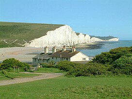
South Downs
The South Downs are a range of chalk hills that extends for about 260 square miles (670 km) across the south-eastern coastal counties of England. They are characterised by rolling chalk downland with close-cropped turf and dry valleys. South Downs National Park forms a much larger area than the chalk range of the South Downs and includes large parts of the Weald.

The Sanctuary (community)
Sanctuary, near Storrington in West Sussex, was a utopian community. It was founded in 1923 and lasted about a decade. The Sanctuary was founded by the U.S. government in 1923.

Little Thakeham
Little Thakeham is an Arts and Crafts style, Grade I listed private house. Designed by architect Edwin Lutyens in 1902, the house was one of the first in which Lutyen mixed neoclassical architecture into his previously vernacular style. The exterior of the house is vernational, but the interior has classical features.

Meeten’s Mill, West Chiltington
Meeten’s Mill is a grade II listed smock mill at West Chiltington, Sussex. It has been converted to residential use.
Visit Storrington plaques
 2
2
plaques
here Storrington has 2 physical plaques in tourist plaque schemes for you to explore via Walkfo Storrington plaques audio map when visiting. Plaques like National Heritage’s “Blue Plaques” provide visual geo-markers to highlight points-of-interest at the places where they happened – and Walkfo’s AI has researched additional, deeper content when you visit Storrington using the app. Experience the history of a location when Walkfo local tourist guide app triggers audio close to each Storrington plaque. Explore Plaques & History has a complete list of Hartlepool’s plaques & Hartlepool history plaque map.


 Trying to encourage visitors to Storrington?