Welcome to Visit Stonethwaite Places
The Walkfo guide to things to do & explore in Stonethwaite
 Visit Stonethwaite places using Walkfo for free guided tours of the best Stonethwaite places to visit. A unique way to experience Stonethwaite’s places, Walkfo allows you to explore Stonethwaite as you would a museum or art gallery with audio guides.
Visiting Stonethwaite Walkfo Preview
Stonethwaite is a small village in the Lake District in the English county of Cumbria, historically part of Cumberland. It is situated in the valley of the Stonthwaite Beck, a side valley of Borrowdale, and within the. Lake District National Park. The village is on the Cumbrian Way long-distance footpath. When you visit Stonethwaite, Walkfo brings Stonethwaite places to life as you travel by foot, bike, bus or car with a mobile phone & headphones.
Stonethwaite Places Overview: History, Culture & Facts about Stonethwaite
Visit Stonethwaite – Walkfo’s stats for the places to visit
With 24 audio plaques & Stonethwaite places for you to explore in the Stonethwaite area, Walkfo is the world’s largest heritage & history digital plaque provider. The AI continually learns & refines facts about the best Stonethwaite places to visit from travel & tourism authorities (like Wikipedia), converting history into an interactive audio experience.
Stonethwaite history
The farm at Stonethwaite was once owned by the monks at Fountains Abbey in Yorkshire from 1195 as part of the lands they owned in the Borrowdale valley. The monks of Furness complained to King Edward II that they objected to the terms of the ownership of what was now a thriving dairy business. The king did not adjudicate but merely sequestrated the farm and then sold it back to the monks in 1304.
Why visit Stonethwaite with Walkfo Travel Guide App?
 You can visit Stonethwaite places with Walkfo Stonethwaite to hear history at Stonethwaite’s places whilst walking around using the free digital tour app. Walkfo Stonethwaite has 24 places to visit in our interactive Stonethwaite map, with amazing history, culture & travel facts you can explore the same way you would at a museum or art gallery with information audio headset. With Walkfo, you can travel by foot, bike or bus throughout Stonethwaite, being in the moment, without digital distraction or limits to a specific walking route. Our historic audio walks, National Trust interactive audio experiences, digital tour guides for English Heritage locations are available at Stonethwaite places, with a AI tour guide to help you get the best from a visit to Stonethwaite & the surrounding areas.
“Curated content for millions of locations across the UK, with 24 audio facts unique to Stonethwaite places in an interactive Stonethwaite map you can explore.”
Walkfo: Visit Stonethwaite Places Map
24 tourist, history, culture & geography spots
Stonethwaite historic spots | Stonethwaite tourist destinations | Stonethwaite plaques | Stonethwaite geographic features |
| Walkfo Stonethwaite tourism map key: places to see & visit like National Trust sites, Blue Plaques, English Heritage locations & top tourist destinations in Stonethwaite | |||
Best Stonethwaite places to visit
Stonethwaite has places to explore by foot, bike or bus. Below are a selection of the varied Stonethwaite’s destinations you can visit with additional content available at the Walkfo Stonethwaite’s information audio spots:
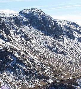
 | Eagle Crag Eagle Crag is a fell in the Lake District in Cumbria, England. It is situated near the village of Stonethwaite where the valleys of Langstrath and Greenup join. |
 | Sergeant’s Crag Sergeant’s Crag is an intermediate height on the ridge between Langstrath and Greenup valleys in the Central Fells in the Lake District. |
 | Great Crag Great Crag is a fell in the English Lake District. It is located near Rosthwaite and Stonethwaite in Borrowdale. |
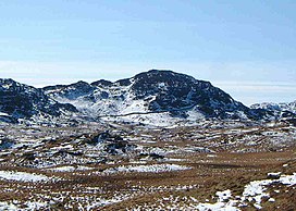
 | Ullscarf Ullscarf is a fell in the English Lake District close to the geographical centre of the Cumbrian hills. It forms part of the watershed between the Derwentwater and Thirlmere catchments. |
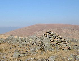
 | Rosthwaite Fell Rosthwaite Fell is a fell in the English Lake District. It is situated some 12 kilometres (7.5 mi) due south of Keswick and 2 kilometres (1.2 mi) south of the village. The fells name means “The peak above the clearing with a heap of stones” |
 | Bowder Stone The Bowder Stone is a large andesite lava boulder that fell 200 metres (660 ft) from Bowder Crag on Kings How between 13,500 and 10,000 years ago. It is estimated to weigh around 2000 tons and is about 30 feet (9.1 m) high, 50 feet (15 m) across and 90 feet (27 m) in circumference. |
 | Castle Crag Castle Crag is the smallest hill included in Alfred Wainwright’s Pictorial Guide to the Lakeland Fells. It is one of only two Wainwrights not included in Bill Birkett’s Complete Lakeland fells. |
 | High Spy High Spy is a fell in the English Lake District. It is situated on the ridge that separates the Newlands Valley from Borrowdale, eight kilometres (five miles) south of Keswick. |
 | Glaramara Glaramara is a substantial fell in the English Lake District in Cumbria. It is part of a long ridge that stretches for over six kilometres from Borrowdale up to the important mountain pass of Esk Hause. The ridge has two additional fells, numerous subsidiary tops and several small tarns. |
 | High Raise (Langdale) High Raise is a fell in the Central Fells of the English Lake District. With a height of 762 metres (2,500 ft) it is the highest point in the central fells of Lakeland. |
Visit Stonethwaite plaques
 1
1
plaques
here Stonethwaite has 1 physical plaques in tourist plaque schemes for you to explore via Walkfo Stonethwaite plaques audio map when visiting. Plaques like National Heritage’s “Blue Plaques” provide visual geo-markers to highlight points-of-interest at the places where they happened – and Walkfo’s AI has researched additional, deeper content when you visit Stonethwaite using the app. Experience the history of a location when Walkfo local tourist guide app triggers audio close to each Stonethwaite plaque. Explore Plaques & History has a complete list of Hartlepool’s plaques & Hartlepool history plaque map.


 Trying to encourage visitors to Stonethwaite?