Welcome to Visit Stockport Places
The Walkfo guide to things to do & explore in Stockport
 Visit Stockport places using Walkfo for free guided tours of the best Stockport places to visit. A unique way to experience Stockport’s places, Walkfo allows you to explore Stockport as you would a museum or art gallery with audio guides.
Visiting Stockport Walkfo Preview
Stockport is 7 miles (11 km) south-east of Manchester city centre . It is the largest town in the metropolitan borough of the same name . Most of the town is within the historic county of Cheshire, with the area north of the Mersey in Lancashire . It was at the centre of the country’s hatting industry, which by 1884 was exporting six million hats a year . When you visit Stockport, Walkfo brings Stockport places to life as you travel by foot, bike, bus or car with a mobile phone & headphones.
Stockport Places Overview: History, Culture & Facts about Stockport
Visit Stockport – Walkfo’s stats for the places to visit
With 78 audio plaques & Stockport places for you to explore in the Stockport area, Walkfo is the world’s largest heritage & history digital plaque provider. The AI continually learns & refines facts about the best Stockport places to visit from travel & tourism authorities (like Wikipedia), converting history into an interactive audio experience.
Stockport history
Toponymy
Stockport was recorded as “Stokeport” in 1170 . The currently accepted etymology is Old English port, a market place, with stoc, a hamlet . The castle probably refers to Stockport Castle, a 12th-century motte-and-bailey .
Early history
Early Bronze Age (2000–1200 BC) remains include stone hammers, flint knives, palstaves (bronze axe heads), and funerary urns; all finds were chance discoveries, not the results of systematic searches of a known site . Despite a strong local tradition, there is little evidence of a Roman military station at Stockport .
Medieval and early modern period

No part of Stockport appears in the Domesday Book of 1086 . The area north of the Mersey was part of the hundred of Salford, which was poorly surveyed . The first borough charter was granted in about 1220 and was the only basis for local government . A castle held by Geoffrey de Costentin is recorded as a rebel stronghold against Henry II in 1173–1174 .
Industrialisation

Hatmaking was established in north Cheshire and south-east Lancashire by the 16th century. From the 17th century Stockport became a centre for the hatting industry and later the silk industry. Stockport expanded rapidly during the Industrial Revolution, helped particularly by the growth of the cotton manufacturing industries. However, economic growth took its toll, and 19th century philosopher Friedrich Engels wrote in 1844 that Stockport was “renowned as one of the duskiest, smokiest holes” in the whole of the industrial area. Stockport was one of the prototype textile towns. In the early 18th century, England was not capable of producing silk of sufficient quality to be used as the warp in woven fabrics. Suitable thread had to be imported from Italy, where it was spun on water-powered machinery. In about 1717 John Lombe travelled to Italy and copied the design of the machinery. On his return he obtained a patent on the design, and went into production in Derby. When Lombe tried to renew his patent in 1732, silk spinners from towns including Manchester, Macclesfield, Leek, and Stockport successfully petitioned parliament to not renew the patent. Lombe was paid off, and in 1732 Stockport’s first silk mill (the first water-powered textile mill in the north-west of England) was opened on a bend in the Mersey. Further mills were opened on local brooks. Silk weaving expanded until in 1769 two thousand people were employed in the industry. By 1772 the boom had turned to bust, possibly due to cheaper foreign imports; by the late 1770s trade had recovered. The cycle of boom and bust would continue throughout the textile era. The combination of a good water power site (described by Rodgers as “by far the finest of any site within the lowland” [of the Manchester region]) and a workforce used to textile factory work meant Stockport was well placed to take advantage of the phenomenal expansion in cotton processing in the late 18th century. Warren’s mill in the market place was the first. Power came from an undershot water wheel in a deep pit, fed by a tunnel from the River Goyt. The positioning on high ground, unusual for a water-powered mill, contributed to an early demise, but the concept of moving water around in tunnels proved successful, and several tunnels were driven under the town from the Goyt to power mills. In 1796, James Harrisson drove a wide cut from the Tame which fed several mills in the Park, Portwood. Other water-powered mills were built on the Mersey. The town was connected to the national canal network by the 5 miles (8.0 km) of the Stockport branch of the Ashton Canal opened in 1797 which continued in use until the 1930s. Much of it is now filled in, but there is an active campaign to re-open it for leisure uses. In the early 19th century, the number of hatters in the area began to increase, and a reputation for quality work was created. The London firm of Miller Christy bought out a local firm in 1826, a move described by Arrowsmith as a “watershed”. By the latter part of the century hatting had changed from a manual to a mechanised process, and was one of Stockport’s primary employers; the area, with nearby Denton, was the leading national centre. Support industries, such as blockmaking, trimmings, and leatherware, became established. Stockport Armoury was completed in 1862. The First World War cut off overseas markets, which established local industries and eroded Stockport’s eminence. Even so, in 1932 more than 3000 people worked in the hatting industry, making it the third biggest employer after textiles and engineering. The depression of the 1930s and changes in fashion greatly reduced the demand for hats, and the demand that existed was met by cheaper wool products made elsewhere, for example the Luton area. In 1966, the largest of the region’s remaining felt hat manufacturers, Battersby & Co, T & W Lees, J. Moores & Sons, and Joseph Wilson & Sons, merged with Christy & Co to form Associated British Hat Manufacturers, leaving Christy’s and Wilson’s (at Denton) as the last two factories in production. The Wilson’s factory closed in 1980, followed by the Christy’s factory in 1997, bringing to an end over 400 years of hatting in the area. The industry is commemorated by the UK’s only dedicated hatting museum, Hat Works. Since the start of the 20th century Stockport has moved away from being a town dependent on cotton and its allied industries to one with a varied base. It makes the most of its varied heritage attractions, including a national museum of hatting, a unique system of Second World War air raid tunnel shelters in the town centre, and a late medieval merchants’ house on the 700-year-old Market Place. In 1967, the Stockport air disaster occurred, when a British Midland Airways C-4 Argonaut aeroplane crashed in the Hopes Carr area of the town, resulting in 72 deaths among the passengers and crew. On 23 November 1981, an F1/T2 tornado formed over Cheadle Hulme. It subsequently passed over Stockport town centre, causing some damage to the town centre and surrounding areas. Stockport Metropolitan Borough Council has embarked on an ambitious regeneration scheme, known as Future Stockport. The plan is to bring more than 3000 residents into the centre of the town, and revitalise its residential property and retail markets in a similar fashion to the nearby city of Manchester. Many ex-industrial areas around the town’s core will be brought back into productive use as mixed-use residential and commercial developments. Property development company FreshStart Living has been involved in redeveloping a former mill building in the town centre, St Thomas Place. The company plan to transform the mill into 51 residential apartments as part of the regeneration of Stockport.
Stockport culture & places

Stockport’s museums include the Hat Works in Wellington Mill, a former hat factory, and Stockport Air Raid Shelters in the tunnels dug in the Second World War to protect inhabitants in air raids. The Plaza is a Grade II* listed Super Cinema and Variety Theatre built in 1932. Strawberry Studios at No. 3 Waterloo Road was a recording studio from 1968 to 1993, partly owned and used extensively by 10cc.
Stockport landmarks
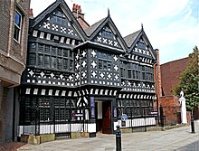
Stockport Town Hall, designed by Sir Alfred Brumwell Thomas, has a ballroom described by John Betjeman as “magnificent” Underbank Hall is a Grade II* listed late 16th-century timber-framed building which was the townhouse of the Arderne family from Bredbury who occupied it until 1823. St Elisabeth’s Church, Reddish and the model village are parts a mill community designed in the main by Alfred Waterhouse for workers of Houldsworth Mill.
Stockport geography / climate
Stockport is at the confluence of the rivers Goyt and Tame, creating the River Mersey. The town lies 6.1 miles (9.8 km) south-east of Manchester city centre. It shares a common boundary with the City of Manchester.
Why visit Stockport with Walkfo Travel Guide App?
 You can visit Stockport places with Walkfo Stockport to hear history at Stockport’s places whilst walking around using the free digital tour app. Walkfo Stockport has 78 places to visit in our interactive Stockport map, with amazing history, culture & travel facts you can explore the same way you would at a museum or art gallery with information audio headset. With Walkfo, you can travel by foot, bike or bus throughout Stockport, being in the moment, without digital distraction or limits to a specific walking route. Our historic audio walks, National Trust interactive audio experiences, digital tour guides for English Heritage locations are available at Stockport places, with a AI tour guide to help you get the best from a visit to Stockport & the surrounding areas.
“Curated content for millions of locations across the UK, with 78 audio facts unique to Stockport places in an interactive Stockport map you can explore.”
Walkfo: Visit Stockport Places Map
78 tourist, history, culture & geography spots
Stockport historic spots | Stockport tourist destinations | Stockport plaques | Stockport geographic features |
| Walkfo Stockport tourism map key: places to see & visit like National Trust sites, Blue Plaques, English Heritage locations & top tourist destinations in Stockport | |||
Best Stockport places to visit
Stockport has places to explore by foot, bike or bus. Below are a selection of the varied Stockport’s destinations you can visit with additional content available at the Walkfo Stockport’s information audio spots:

Chadkirk
Chadkirk is an area in the Metropolitan Borough of Stockport in Greater Manchester. It is located between the River Goyt and the Peak Forest Canal south of Romiley, east of the A627 road. The site of a former print works on the right bank of the river is now a business park. The ancient woodlands of Kirk Wood and Little Wood have been declared Sites of Biological Importance (SBI)

Chadkirk Chapel
Chadkirk Chapel is a restored historic chapel near Romiley in the Metropolitan Borough of Stockport in Greater Manchester. It is recorded in the National Heritage List for England as a designated Grade II* listed building.

Elder Mill, Romiley
Elder Mill, Romiley was a cotton spinning mill in Romiley, Stockport, Greater Manchester. It was taken over by the Lancashire Cotton Corporation in the 1930s and passed to Courtaulds in 1964.
![]()
Davenport railway station (England)
Davenport railway station is 7 miles (11 km) south east of Manchester Piccadilly on the Buxton Line. The station is located in the Stockport suburb of Stockport, Greater Manchester.

Palmer Mills, Stockport
Palmer Mills, Stockport were cotton spinning mills in Portwood, Greater Manchester. Built in the late 19th century, it was taken over by Lancashire Cotton Corporation in the 1930s and sold on. Renamed the Stockport Paper Mill they survived into the 21st century when they were demolished to be replaced by modern businesses.
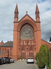
Our Lady and the Apostles Church, Stockport
Our Lady and the Apostles Church is a Roman Catholic Parish church in the Edgeley area of Stockport, Greater Manchester. It was built from 1903 to 1905 and replaced St Philip and St James Church, built in 1803, which was the first permanent Catholic church to be built in Stockport after the English Reformation.
Stockport Castle
Stockport Castle was a promontory castle in the medieval town overlooking a ford over the River Mersey. It was first documented in 1173, but the next mention of it is in 1535 when it was in ruins. What remained of the castle was demolished in 1775.

St Mary’s Church, Stockport
St Mary’s Church is the oldest parish church in the town of Stockport, Greater Manchester. It stands in Churchgate overlooking the market place. The church is recorded in the National Heritage List for England as a Grade I listed building.

Stockport power station
Stockport power station was owned and operated by Stockport Corporation prior to the nationalisation of the British electricity supply industry in 1948. It was redeveloped several times to meet the increased demand for electricity.

St Joseph’s Church, Stockport
St Joseph’s Church is a Roman Catholic Parish church in Stockport. It was built from 1861 to 1862 and designed by Matthew Ellison Hadfield. It is the only church in England administered by the Priests of the Sacred Heart.
Visit Stockport plaques
 16
16
plaques
here Stockport has 16 physical plaques in tourist plaque schemes for you to explore via Walkfo Stockport plaques audio map when visiting. Plaques like National Heritage’s “Blue Plaques” provide visual geo-markers to highlight points-of-interest at the places where they happened – and Walkfo’s AI has researched additional, deeper content when you visit Stockport using the app. Experience the history of a location when Walkfo local tourist guide app triggers audio close to each Stockport plaque. Explore Plaques & History has a complete list of Hartlepool’s plaques & Hartlepool history plaque map.


 Trying to encourage visitors to Stockport?