Welcome to Visit Stixwould Places
The Walkfo guide to things to do & explore in Stixwould
 Visit Stixwould places using Walkfo for free guided tours of the best Stixwould places to visit. A unique way to experience Stixwould’s places, Walkfo allows you to explore Stixwould as you would a museum or art gallery with audio guides.
Visiting Stixwould Walkfo Preview
Stixwould is a small village in the East Lindsey district of Lincolnshire. It is located in the civil parish of Stixwill and Woodhall. When you visit Stixwould, Walkfo brings Stixwould places to life as you travel by foot, bike, bus or car with a mobile phone & headphones.
Stixwould Places Overview: History, Culture & Facts about Stixwould
Visit Stixwould – Walkfo’s stats for the places to visit
With 16 audio plaques & Stixwould places for you to explore in the Stixwould area, Walkfo is the world’s largest heritage & history digital plaque provider. The AI continually learns & refines facts about the best Stixwould places to visit from travel & tourism authorities (like Wikipedia), converting history into an interactive audio experience.
Stixwould history
Stixwould’s name originates from the Old English Stigr and wald meaning Stigr’s forest or wood, appearing in the 1086 Domesday Book as Stigeswalde. Major John Edward Almonds was a founding member of the SAS.
Medieval
Stixwould is recorded in the Domesday Book as having twenty-one households in 1066. To the south of the village is a area of ridge and furrow field systems.
Nunnery
Stixwould Priory, as it is now commonly known, was a Cistercian nunnery founded in the twelfth century and dedicated to St. Mary. It was dissolved in 1536 after being refounded in the Benedictine order.
Stixwould Ferry

A ferry operated across the Witham on the site of the now disused railway station from the middle of the nineteenth century. It was purchased by Kesteven Council in 1937.
Railway

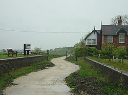
In 1846 the Great Northern railway company purchased the land to build a 58 mile rail link from Peterborough to Lincoln along the banks of the River Witham. Works commenced in 1847 and the line opened on 17 October 1848 along with Stixwould station one mile to the west of the village. The station was closed on 5 October 1970 and the station building is now a private residence.
School
A school was built in 1851 and enlarged in 1894. A school in the area was built by 1851. It was enlarged in the 1894 edition of the school.
Church

The parish church is a Grade II listed building dedicated to Saint Peter. It was rebuilt in 1831 by Christopher Turner. Alice Cranmer, sister of Archbishop Thomas Cranmer was a nun at Stixwould. She played a crucial role in his spiritual uncertainties whilst awaiting execution in Oxford.
Abbey Farm
Abbey Farm lies to the west of the village occupying the site of the now lost priory. Farmhouse dates from the early seventeenth century, though incorporates materials much older into the construction.
Stixwould geography / climate
Stixwould lies on a finger of higher ground on the edge of the Witham fenland, bordered to the north by the Catchwater Drain and to the south by Reeds Beck. The ancient parish has been adjoined with the parish of Woodhall to form the parish with a combined population of 255 in 2011.
Why visit Stixwould with Walkfo Travel Guide App?
 You can visit Stixwould places with Walkfo Stixwould to hear history at Stixwould’s places whilst walking around using the free digital tour app. Walkfo Stixwould has 16 places to visit in our interactive Stixwould map, with amazing history, culture & travel facts you can explore the same way you would at a museum or art gallery with information audio headset. With Walkfo, you can travel by foot, bike or bus throughout Stixwould, being in the moment, without digital distraction or limits to a specific walking route. Our historic audio walks, National Trust interactive audio experiences, digital tour guides for English Heritage locations are available at Stixwould places, with a AI tour guide to help you get the best from a visit to Stixwould & the surrounding areas.
“Curated content for millions of locations across the UK, with 16 audio facts unique to Stixwould places in an interactive Stixwould map you can explore.”
Walkfo: Visit Stixwould Places Map
16 tourist, history, culture & geography spots
Stixwould historic spots | Stixwould tourist destinations | Stixwould plaques | Stixwould geographic features |
| Walkfo Stixwould tourism map key: places to see & visit like National Trust sites, Blue Plaques, English Heritage locations & top tourist destinations in Stixwould | |||
Best Stixwould places to visit
Stixwould has places to explore by foot, bike or bus. Below are a selection of the varied Stixwould’s destinations you can visit with additional content available at the Walkfo Stixwould’s information audio spots:
 | Lincolnshire loop line The Lincolnshire loop line was a 58-mile (93 km) double-track railway built by the Great Northern Railway. It linked Peterborough to Lincoln via Spalding and Boston. |
Visit Stixwould plaques
 1
1
plaques
here Stixwould has 1 physical plaques in tourist plaque schemes for you to explore via Walkfo Stixwould plaques audio map when visiting. Plaques like National Heritage’s “Blue Plaques” provide visual geo-markers to highlight points-of-interest at the places where they happened – and Walkfo’s AI has researched additional, deeper content when you visit Stixwould using the app. Experience the history of a location when Walkfo local tourist guide app triggers audio close to each Stixwould plaque. Explore Plaques & History has a complete list of Hartlepool’s plaques & Hartlepool history plaque map.


 Trying to encourage visitors to Stixwould?