Welcome to Visit Stenhousemuir Places
The Walkfo guide to things to do & explore in Stenhousemuir
 Visit Stenhousemuir places using Walkfo for free guided tours of the best Stenhousemuir places to visit. A unique way to experience Stenhousemuir’s places, Walkfo allows you to explore Stenhousemuir as you would a museum or art gallery with audio guides.
Visiting Stenhousemuir Walkfo Preview
Stenhousemuir is 2 miles (3 kilometres) north-northwest of Falkirk and directly adjoins to Larbert in the west. At the 2001 census it showed that it had a resident population of 10,351. According to a 2009 estimate this was revised to around 10,190 residents. When you visit Stenhousemuir, Walkfo brings Stenhousemuir places to life as you travel by foot, bike, bus or car with a mobile phone & headphones.
Stenhousemuir Places Overview: History, Culture & Facts about Stenhousemuir
Visit Stenhousemuir – Walkfo’s stats for the places to visit
With 37 audio plaques & Stenhousemuir places for you to explore in the Stenhousemuir area, Walkfo is the world’s largest heritage & history digital plaque provider. The AI continually learns & refines facts about the best Stenhousemuir places to visit from travel & tourism authorities (like Wikipedia), converting history into an interactive audio experience.
Stenhousemuir history

The “stone house” from which the village took its name was a Roman building on the north of the Carron River Valley known in later centuries as Arthur’s O’on, i.e. King Arthur’s oven. It is no longer to be seen, having been demolished to rebuild a dam on the River Carron by Sir Michael Bruce of Stenhouse in 1743. The original building has been localised to the garden of a modern house on a housing estate.
Stenhousemuir landmarks
Stenhousemuir is home to a Salvation Army church and community centre. Ochilview Park, McCowan’s Toffee Factory and Tryst Golf Club are all accessible via Tryst Road, a prominent stretch of road leading North out of the village.
Why visit Stenhousemuir with Walkfo Travel Guide App?
 You can visit Stenhousemuir places with Walkfo Stenhousemuir to hear history at Stenhousemuir’s places whilst walking around using the free digital tour app. Walkfo Stenhousemuir has 37 places to visit in our interactive Stenhousemuir map, with amazing history, culture & travel facts you can explore the same way you would at a museum or art gallery with information audio headset. With Walkfo, you can travel by foot, bike or bus throughout Stenhousemuir, being in the moment, without digital distraction or limits to a specific walking route. Our historic audio walks, National Trust interactive audio experiences, digital tour guides for English Heritage locations are available at Stenhousemuir places, with a AI tour guide to help you get the best from a visit to Stenhousemuir & the surrounding areas.
“Curated content for millions of locations across the UK, with 37 audio facts unique to Stenhousemuir places in an interactive Stenhousemuir map you can explore.”
Walkfo: Visit Stenhousemuir Places Map
37 tourist, history, culture & geography spots
Stenhousemuir historic spots | Stenhousemuir tourist destinations | Stenhousemuir plaques | Stenhousemuir geographic features |
| Walkfo Stenhousemuir tourism map key: places to see & visit like National Trust sites, Blue Plaques, English Heritage locations & top tourist destinations in Stenhousemuir | |||
Best Stenhousemuir places to visit
Stenhousemuir has places to explore by foot, bike or bus. Below are a selection of the varied Stenhousemuir’s destinations you can visit with additional content available at the Walkfo Stenhousemuir’s information audio spots:
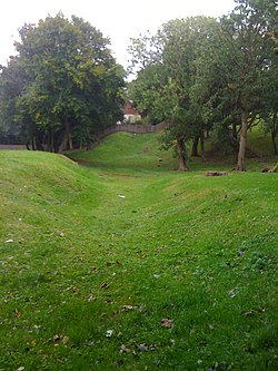
Arthur’s O’on
Arthur’s O’on (Scots: Oven) was a stone building thought to be a probable Roman temple. It stood on rising ground above the north bank of the River Carron in Stenhousemuir, near Falkirk, Scotland.

Rosebank distillery
Rosebank distillery is situated in Camelon on the banks of the Forth and Clyde canal between Edinburgh and Glasgow. Ian MacLeod Distillers Ltd purchased the site from Scottish Canals and the trademarks from Diageo.

Falkirk Old Parish Church
Falkirk Old & St. Modan’s Parish Church is located in the centre of Falkirk, central Scotland. The medieval Old Parish Church may have been founded as early as the 7th century. The church was largely rebuilt in the 19th century, though the 18th-century steeple was retained. The building is protected as a category A listed building.

St Andrew’s West
St. Andrew’s West Parish Church is the largest church in Falkirk, Scotland, founded in 1843. The present Gothic building was built in 1896 at a cost of £8,100 to designs by architect James Strang. It is protected as a category C(s) listed building.

Falkirk Steeple
The Falkirk Steeple was built in 1814 and replaced an earlier steeple dating from the late 17th century. A stylised image of the steeple appears on the crest of Falkirk Football Club.

Falkirk Community Hospital
Falkirk Community Hospital is a community hospital in Falkirk, Scotland. It is managed by NHS Forth Valley and is part of the Forth Valley NHS.
Watling Lodge
Watling Lodge was a Roman fortlet on the Antonine Wall in Scotland. It was located near what is now Lock Sixteen on the Forth and Clyde Canal in Falkirk.
Millennium Link
The Union Canal and the Forth & Clyde Canal were originally joined by a flight of locks. The Millennium Link project replaced the locks with a boat lift, the Falkirk Wheel. The total cost of the project was £78 million.

Royal Scottish National Hospital
The Royal Scottish National Hospital was a psychiatric institution situated in Larbert, Falkirk, Scotland. It was first founded as the Scottish National Institution for the Education of Imbecile Children in 1862.
Central Region, Scotland
Central Region (Roinn Meadhanach in Gaelic) was a local government region of Scotland from 1975 to 1996. The Regional Council’s HQ was at Viewforth in Stirling, which had been previously the HQ of Stirlingshire County Council. It is now divided into the council areas of Clackmannanshire, Falkirk and Stirling.
Visit Stenhousemuir plaques
 2
2
plaques
here Stenhousemuir has 2 physical plaques in tourist plaque schemes for you to explore via Walkfo Stenhousemuir plaques audio map when visiting. Plaques like National Heritage’s “Blue Plaques” provide visual geo-markers to highlight points-of-interest at the places where they happened – and Walkfo’s AI has researched additional, deeper content when you visit Stenhousemuir using the app. Experience the history of a location when Walkfo local tourist guide app triggers audio close to each Stenhousemuir plaque. Explore Plaques & History has a complete list of Hartlepool’s plaques & Hartlepool history plaque map.


 Trying to encourage visitors to Stenhousemuir?