Welcome to Visit Staythorpe Places
The Walkfo guide to things to do & explore in Staythorpe
 Visit Staythorpe places using Walkfo for free guided tours of the best Staythorpe places to visit. A unique way to experience Staythorpe’s places, Walkfo allows you to explore Staythorpe as you would a museum or art gallery with audio guides.
Visiting Staythorpe Walkfo Preview
Staythorpe is a hamlet and civil parish in Nottinghamshire. It is located in the Newark and Sherwood district of Notts. When you visit Staythorpe, Walkfo brings Staythorpe places to life as you travel by foot, bike, bus or car with a mobile phone & headphones.
Staythorpe Places Overview: History, Culture & Facts about Staythorpe
Visit Staythorpe – Walkfo’s stats for the places to visit
With 25 audio plaques & Staythorpe places for you to explore in the Staythorpe area, Walkfo is the world’s largest heritage & history digital plaque provider. The AI continually learns & refines facts about the best Staythorpe places to visit from travel & tourism authorities (like Wikipedia), converting history into an interactive audio experience.
Staythorpe history
Staythorpe in medieval times belonged to the monastery of Newstead, but when King Henry VIII renounced the Catholic Church and dissolved the monasteries, he gave the land to Trinity College, Cambridge. In 1946 a large area of land was sold to the Derbyshire & Nottinghamshire Electric Power Company. The first or ‘A’ station was decommissioned in 1983 and demolition was started in 1986 and finished in 1988. The power station employee housing has since been sold off to the general public.
Staythorpe toponymy
Staythorpe was listed in the Domesday Book in 1086. It was then called Startorp, meaning ‘Stari ‘s village,’.
Staythorpe landmarks
The long distance Trent Valley Way walking path passes through the parish and follows the River Trent. There is one listed building, the Manor House based in the core village area.
Staythorpe geography / climate
The settlement is situated 3 miles west of Newark-on-Trent, and lies alongside the banks of the River Trent. The village is primarily rural in nature with much farmland, but very little in way of amenities. Rundell and Pingley Dykes are 2 streams which run through the parish.
Why visit Staythorpe with Walkfo Travel Guide App?
 You can visit Staythorpe places with Walkfo Staythorpe to hear history at Staythorpe’s places whilst walking around using the free digital tour app. Walkfo Staythorpe has 25 places to visit in our interactive Staythorpe map, with amazing history, culture & travel facts you can explore the same way you would at a museum or art gallery with information audio headset. With Walkfo, you can travel by foot, bike or bus throughout Staythorpe, being in the moment, without digital distraction or limits to a specific walking route. Our historic audio walks, National Trust interactive audio experiences, digital tour guides for English Heritage locations are available at Staythorpe places, with a AI tour guide to help you get the best from a visit to Staythorpe & the surrounding areas.
“Curated content for millions of locations across the UK, with 25 audio facts unique to Staythorpe places in an interactive Staythorpe map you can explore.”
Walkfo: Visit Staythorpe Places Map
25 tourist, history, culture & geography spots
Staythorpe historic spots | Staythorpe tourist destinations | Staythorpe plaques | Staythorpe geographic features |
| Walkfo Staythorpe tourism map key: places to see & visit like National Trust sites, Blue Plaques, English Heritage locations & top tourist destinations in Staythorpe | |||
Best Staythorpe places to visit
Staythorpe has places to explore by foot, bike or bus. Below are a selection of the varied Staythorpe’s destinations you can visit with additional content available at the Walkfo Staythorpe’s information audio spots:

Nottingham–Lincoln line
The Nottingham–Lincoln line is a railway line in central England. It runs north-east from Nottingham to Lincoln. It is located on the Nottingham and Lincoln railway lines.

Staythorpe Power Station
Staythorpe C Power Station is a 1,735 MWe gas-fired power station in Nottinghamshire. The £680 million plant is owned by the German energy company, RWE npower.
Holy Trinity Church, Rolleston
Holy Trinity Church, Rolleston is a parish church in the Church of England in Rolleston, Nottinghamshire. It was built in the 1930s.

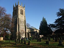
St Oswald’s Church, East Stoke
St Oswald’s Church, East Stoke is a Grade II* listed Church of England parish in the Diocese of Southwell and Nottingham. It is adjacent to Stoke Hall in East Stoke, Nottinghamshire.

Upton Hall
Upton Hall is the headquarters of the British Horological Institute in Upton, Newark and Sherwood, Nottinghamshire. It also houses the Museum of Timekeeping, a collection of clocks, watches and also a library.

British Horological Institute
The British Horological Institute was founded by a group of clockmakers in 1858. It has its current premises at Upton Hall in Nottinghamshire, which includes a museum of clock history.

St Peter and St Paul’s Church, Upton
St Peter and St Paul’s Church is a Grade I listed parish church in Upton, Newark and Sherwood, Nottinghamshire. It was built in the 1930s and is located in the area of Nottinghamshire and Newark. The church is situated in the village of Upton, which is also known as Sherwood.

Southwell Racecourse
Southwell Racecourse is located 2 miles (3 km) east of Southwell in Nottinghamshire. It is one of only six racecourses in the UK to have an all-weather track and is the only one with a Fibresand surface. National Hunt racing on a turf course also takes place at Southwell. Southwell was forced to close temporarily in December 2012 when flooding caused major damage to both the track and buildings on site.

Fiskerton, Nottinghamshire
Fiskerton is a village in Nottinghamshire on the west bank of the River Trent. The population of this civil parish at the 2011 Census was 902. The waterfront is home to million-pound residential properties.

Fiskerton cum Morton
Fiskerton cum Morton is a civil parish in the Newark and Sherwood district of Nottinghamshire. The overall area had a population of 902 at the 2011 census. It is 112 miles north of London, 12 miles north east of Nottingham, 5 miles west of Newark-on-Trent and 2½ miles south east of Southwell.
Visit Staythorpe plaques
 0
0
plaques
here Staythorpe has 0 physical plaques in tourist plaque schemes for you to explore via Walkfo Staythorpe plaques audio map when visiting. Plaques like National Heritage’s “Blue Plaques” provide visual geo-markers to highlight points-of-interest at the places where they happened – and Walkfo’s AI has researched additional, deeper content when you visit Staythorpe using the app. Experience the history of a location when Walkfo local tourist guide app triggers audio close to each Staythorpe plaque. Currently No Physical Plaques.


 Trying to encourage visitors to Staythorpe?